Skip to search
Skip to main content
Digital Commonwealth
Folders
Sign Up / Log In
Search for
Search
Search
Search
Basic
Advanced
Explore
Map
Collections
Institutions
Formats
For Educators
Primary Source Sets
Lesson Plans
Using Primary Sources
Searching Digital Commonwealth
For Institutions
Join Digital Commonwealth
Conferences, Trainings, & Events
How to Contribute Collections
Digitization Services
Board & Committees
Frequently Asked Questions
About
About Digital Commonwealth
News & Announcements
Copyright & Terms of Use
Harmful Content Statement
Partners
API
Contact Us
Historic New England
Nina Heald Webber Cape Cod Canal collection (MS028)
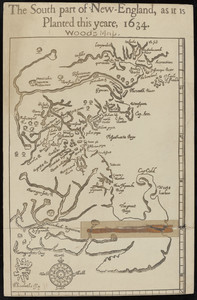
The South part of New England, as it is Planted this yeare, 1634
View this item online at Historic New England
Item Information
Title:
The South part of New England, as it is Planted this yeare, 1634
Description:
A modern reproduction of a 1634 map of the Massachusetts coast, including Cape Cod.
Format:
Maps/Atlases
Manuscripts
Genre:
historical maps
Location:
Historic New England
Collection (local):
MS028: Nina Heald Webber Cape Cod Canal collection
Subjects:
historic sites
Places:
Massachusetts
>
Barnstable (county)
>
Cape Cod
(area)
Extent:
1 map
Link to Item:
http://gusn.us/289286
Terms of Use:
Rights status not evaluated.
Contact host institution for more information.
Identifier:
289286
Call #:
MS028.01.010.013
show more...
View MODS XML
More Like This
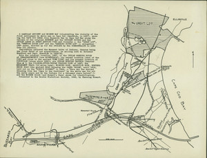
Ancient and modern map of the first settlement on Cape Cod
Cape Cod postcard
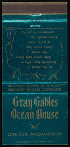
Gray Gables Ocean House matchbook cover
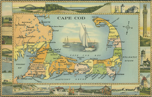
Historical Cape Cod map
Find More Like This >>
Tools
Share
Facebook
Pinterest
X
Reddit
Tumblr
Email
Copy link
Add to Folder
Questions/Comments
Cite This Item