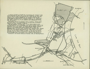
Ancient and modern map of the first settlement on Cape Cod
Description:
A map of Cape Cod showing ancient and modern details, by Channing Howard, presented to the Bourne Historical Society in 1942. The map provides details of old Cape Cod landmarks and settlements. The map includes three paragraphs of text. The first beigns: "A combined ANCIENT and MODERN MAP illustrating the vicinity of the first settlement by white men on Cape Cod (Sandwich, in 1637), showing the CAPE COD CANAL from Buzzards Bay to Cape Cod Bay along the valleys of the original MONUMENT and the SCUSSET RIVERS and the INDIAN LANDS at GREAT HERRING POND and vicinity..."