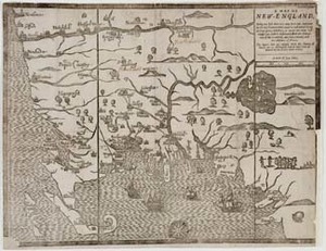
This early map of New England, probably by John Foster, was published in The Present State of New-England by William Hubbard (London, 1677), the London edition of Hubbard’s Narrative of the Troubles with the Indians (Boston, 1677). There are two versions of this map. This version is known as the "Wine Hills" version because the White Hills of New Hampshire are identified as the "Wine Hills." The other version is known as the "White Hills" map. [Boston: printed by John Foster, 1677] Originally published in William Hubbard's The Present State of New-England. "Wine Hills" version.
Item from the collections of the Massachusetts Historical Society. Image use and licensing information: www.masshist.org/library/permissions
Contact host institution for more information.