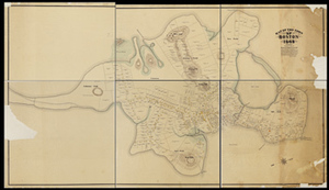
Map of the Town of Boston 1648; Drawn by Samuel C. Clough, in Accordance with Information Compiled from the Records of the Colony ...
Description:
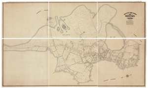
This map by Samuel Chester Clough depicts Boston in 1648 and conveys information about property owners compiled from the records of the colony, town, registry of deeds, Suffolk probate, and Supreme Judicial Court, Book of Possessions, Winthrop Journal, Lechford's notebook, and Aspinwall's notes and city surveys. This map has been divided into six sections. The map shows a densely populated Shawmut peninsula, especially the area around present-day State Street, Government Center, and Faneuil Hall. The hills, fields, and marshland all but disappear over the next century as the land was divided, sold, made, and developed. The map hints that the North End was practically an island, with a tidal creek connecting the Mill Cove to the Great Cove. One map cut into six sheets. From the Samuel Chester Clough research materials toward a topographical history of Boston.
Item from the collections of the Massachusetts Historical Society. Image use and licensing information: www.masshist.org/library/permissions
Contact host institution for more information.