Massachusetts Archives
Massachusetts Metropolitan District Water Supply Commission, Quabbin Reservoir, Photographs of Real Estate in the Swift River Valley, and of General Engineering of Quabbin Reservoir, 1927-1950
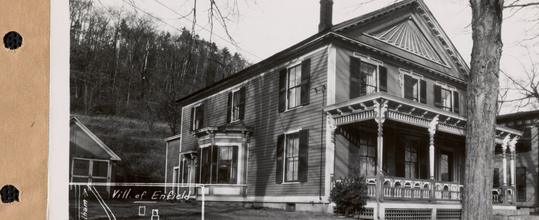
In order to improve the water supply to the greater Boston metropolitan area, the Metropolitan District Water Supply Commission was authorized to take property in the watersheds of the Swift and Ware rivers to develop what became the Quabbin Reservoir. These photographs, largely taken between 1927 and the early 1940s, depict area houses, barns, stores, mills, schools, churches, and other real estate in order to plan their removal, and the reimbursement of the property owners.
After years of engineering study and debate, the Commonwealth created the Metropolitan District Water Supply Commission (MDWSC) to build an improved water supply reservoir and system to serve metropolitan Boston, in the valley of the Swift River, a tributary of the Connecticut River. The Ware River Act (St. 1926, c. 375) and the later Swift River Act (St. 1927, c. 321) directed the flood waters of the Ware River to be diverted, and the Swift River Valley dammed and flooded for a new water supply reservoir. Known as the Swift River Reservoir from 1926-1932, the MDWSC officially renamed it the Quabbin Reservoir on October 25, 1932. The word “Quabbin” is from the Nipmuck, the Native American tribe that historically inhabited the valley, which roughly translates to “the place or the meeting of many waters.”
The Quabbin Reservoir project required the taking of 117 square miles, with the finished reservoir having a water surface of 38.6 square miles, and a 186 square mile watershed. Watershed protection was a major component to the Quabbin Reservoir project. Construction required the relocation of the boundaries of six towns and three counties. Four towns; Dana (est. 1800), Enfield (est. 1815), Greenwich (est. 1754), and Prescott (est. 1821), were deconstructed and then officially disincorporated on April 28, 1938. Other villages and towns impacted included Barre, Belchertown, Hardwick, New Salem, Orange, Pelham, Petersham, Shutesbury, Ware, and Wendell. About 2,500 people living in 650 houses were dislocated; as were schools, churches, cemeteries, farms, businesses, mills and factories, town offices and libraries, railroad lines and stations, town commons, roadways and highways, summer camps and cottages along ponds and lakes, and a golf course.
Per the Acts of 1947, chapter 583, the MDWSC was abolished, and the operation of the Quabbin Reservoir and its associated aqueduct and facilities was transferred to the Metropolitan District Commission (MDC), Water Division (1919-1985), Quabbin Section. In 1985, the operations of the MDC Water Division were divided between two new entities: the MDC, Division of Watershed Management (1985-2003), and the Massachusetts Water Resources Authority. Since 2003, Quabbin Reservoir is managed by the Department of Conservation and Recreation, Division of Water Supply Protection, Office of Watershed Management, Quabbin Region.
This collection consists of more than 2,900 photographic prints (5”x7”). MDWSC employed engineering photographers to document each structure as part of its real estate purchase and removal process. There were also photographs taken of preliminary engineering work, nursery and tree planting work, gypsy moth defoliation, the 1936 floods, houses converted for MDWSC use, milestone events with MDWSC officials, as well as landscape views of the Swift River valley.
The photographic prints were backed with linen cloth (and sometimes stamped in red with the MDWSC name and Boston mailing address on back) and were bound in 59 numbered volumes, 50 prints per volume (2-hole punched, bound with brass fasteners), numbered from 1 to 2931 (more than 100 photographs are currently missing from all surviving sets). Multiple official and reference sets were created (a “Secretary” set, a “Chief Engineer” set, etc.) with many set volumes now lost. In the frame of each real estate photograph is a chalk board, indicating various real estate information, and the date. The photos have a caption along the bottom (called ‘titling’ by the photographers) with changing formats, with the photographer’s last name is nearly always stated. The photographic prints were annotated by the MDWSC with property sale information.
The digital access project was lead jointly by the Massachusetts Department of Conservation and Recreation (Archives) and the Massachusetts Water Resources Authority (Library), co-operators of the water supply system for greater Boston, and in cooperation with the Massachusetts Archives, and the Department of Conservation and Recreation, Division of Water Supply Protection, Office of Watershed Management.