Skip to search
Skip to main content
Skip to first result
Digital Commonwealth
Folders
Sign Up / Log In
Search for
Search
Search
Search
Basic
Advanced
Explore
Map
Collections
Institutions
Formats
For Educators
Primary Source Sets
Lesson Plans
Using Primary Sources
Searching Digital Commonwealth
For Institutions
Join Digital Commonwealth
Conferences, Trainings, & Events
How to Contribute Collections
Digitization Services
Board & Committees
Frequently Asked Questions
About
About Digital Commonwealth
News & Announcements
Copyright & Terms of Use
Harmful Content Statement
Partners
API
Contact Us
Search
Search Constraints
Start Over
Save Search
Your search:
More Like
commonwealth-oai:ww72bj185
✖
Remove constraint More Like: commonwealth-oai:ww72bj185
« Prev.
|
281
-
300
of
368
|
Next »
Sort
by relevance
relevance
title
date (asc)
date (desc)
Number of results to display per page
20
per page
per page
10
per page
20
per page
50
per page
100
per page
View results as:
List
list view
Maps
map view
Gallery
grid view
Search Results
281.
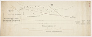
Plan of the proposed location for a railroad from Amesbury, Massachusetts to Epping, New Hampshire via Exeter, New Hampshire...
282.
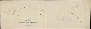
Plan of the proposed route for railroad from Holyoke to Belchertown / surveyed by George R. Nash, civil engineer.
283.
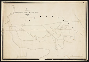
Plan of the proposed straightening of the Eastern Railroad, North River, Salem / T. Willis Pratt, engineer.
284.
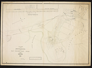
Plan of the proposed termination of the Old Colony Railroad near Pearl St. Boston / S.D. Eaton, engr.
285.
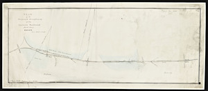
Plan of the route to Commercial Point and Pine Neck / S.D. Eaton, engr.
286.
Plan of the Roxbury Branch railroad / E. Appleton, civil engineer.
287.
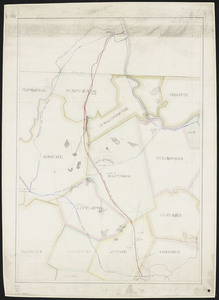
Plan of the Ware River Railroad from Palmer to Winchendon, Massachusetts
288.
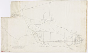
[Plan of the] W.R.R. Palmer depot / by H.M. Butler from surveys by Wm. H. Butler.
289.
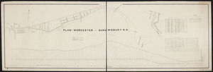
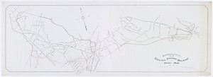
Plan of Worcester and Shrewsbury R.R.
290.
Plan, profile and report of a railroad from Boston & Maine extension at Malden through Saugus, Lynn and Danvers to Salem.
291.
Plan showing location of Boston, Revere Beach & Lynn Rail Road
292.
Plan showing the route of proposed railroad from Marblehead to Swampscott, drawn from town and county maps / Charles A. Putnam.
293.
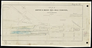
Plans and proposed enlargements of the Boston and Maine Railroad in the city of Boston.
294.
Profile of Lanesboro and Williamstown r. road
295.
Proposed change of location of the Boston and Worcester Railroad between Brighton Station and the town line of Newton / E.S....
296.
Proposed location of an electric freight railroad at Quincy, Mass. / Gilbert Hodges, civil engineer.
297.
Proposed railroad from Acton to Nashua.
298.
Proposed route and details for a suspension railway from East Boston to Lynn / by Robert H. Eddy, civil engineer.
299.
Rail road route from South Acton to Lancaster
300.
Rail road route from the Fitchburg at Shirley through Townsend to the New Hampshire line / Felton and Parker's Office, Geo. A....
« Previous
Next »
1
2
…
11
12
13
14
15
16
17
18
19
Limit your search
Subject
Railroads--Massachusetts
59
Railroads--Massachusetts--Maps
13
Massachusetts--Maps
9
Old Colony Railroad
8
Boston and Maine Railroad--Maps
7
Massachusetts. Board of Railroad Commissioners
7
Massachusetts. Public Service Commission
7
Public utilities--Massachusetts
7
more
Subject
»
Place
North and Central America
368
United States
368
Massachusetts
356
Middlesex (county)
91
Boston
71
Suffolk (county)
71
Norfolk (county)
46
Essex (county)
43
more
Place
»
Format
Maps/Atlases
269
Documents
99
Date
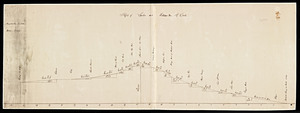
View distribution
Current results range from
1827
to
1919
Date range begin
Date range end
View larger »
Unknown
56
Collection
Massachusetts Board of Railroad Commissioners
368
Institution
State Library of Massachusetts
368
![[Plan of the] W.R.R. Palmer depot / by H.M. Butler from surveys by Wm. H. Butler.](https://bpldcassets.blob.core.windows.net/derivatives/metadata/commonwealth-oai:x633fg94g/image_thumbnail_300.jpg)