Skip to search
Skip to main content
Skip to first result
Digital Commonwealth
Folders
Sign Up / Log In
Search for
Search
Search
Search
Basic
Advanced
Explore
Map
Collections
Institutions
Formats
For Educators
Primary Source Sets
Lesson Plans
Using Primary Sources
Searching Digital Commonwealth
For Institutions
Join Digital Commonwealth
Conferences, Trainings, & Events
How to Contribute Collections
Digitization Services
Board & Committees
Frequently Asked Questions
About
About Digital Commonwealth
News & Announcements
Copyright & Terms of Use
Harmful Content Statement
Partners
API
Contact Us
Search
Search Constraints
Start Over
Save Search
Your search:
More Like
commonwealth-oai:ww72bf933
✖
Remove constraint More Like: commonwealth-oai:ww72bf933
« Prev.
|
341
-
360
of
433
|
Next »
Sort
by date (desc)
relevance
title
date (asc)
date (desc)
Number of results to display per page
20
per page
per page
10
per page
20
per page
50
per page
100
per page
View results as:
List
list view
Maps
map view
Gallery
grid view
Search Results
341.
Portable horizontal boiler used in construction of Hoosac Tunnel 1864
342.
Portable upright boiler used in construction of dam in Deerfield River and elsewhere on Hoosac Tunnel 1864
343.
Safety cages for west shaft of Hoosac Tunnel
344.
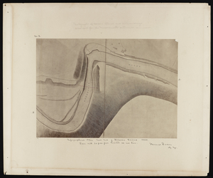
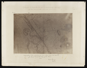
Topographical plan east end of Hoosac Tunnel 1864
345.
Topographical plan east end of Hoosac Tunnel 1864
346.
Topographical plan east end of Hoosac Tunnel 1864
347.
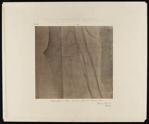
Topographical plan from west shaft to west end of Hoosac Tunnel 1864
348.
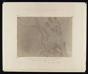
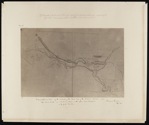
Topographical plan of the Hoosick River valley between the west end of the Hoosac Tunnel and the village of North Adams 1864
349.
Topographical plan of the Hoosick River valley between the west end of the Hoosac Tunnel and the village of North Adams 1864
350.
Topographical plan of the Hoosick River valley between the west end of the Hoosac Tunnel and the village of North Adams 1864
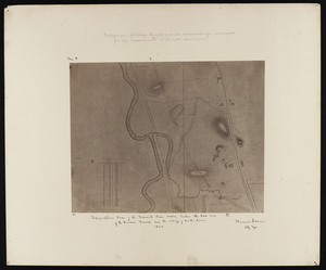
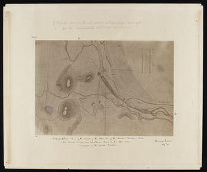
351.
Topographical plan of the vicinity of the west end of the Hoosac Tunnel 1864
352.
Topographical plan of the vicinity of the west end of the Hoosac Tunnel 1864
353.
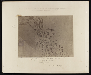
Topographical plan of the village of North Adams which lies about 2 miles from the west end of Hoosac Tunnel 1864
354.
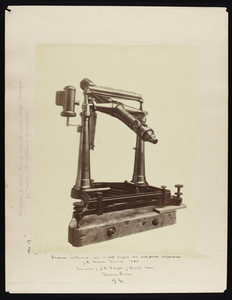
Transit instrument used in both surface and underground alignment of the Hoosac Tunnel 1864
355.
Blacksmith's shop at the east end of the Hoosac Tunnel
356.
Details of instrument houses used in surface alignment of the Hoosac Tunnel
357.
Plan and elevation of instrument houses used in surface alignment of the Hoosac Tunnel
358.
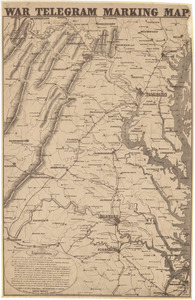
War telegram marking map
359.
Plan of lands on the Back Bay, belonging to the Boston Water Power Co., the Commonwealth, and other parties, showing the system...
360.
Plan of lands belonging to the Boston Water Power Company and the Commonwealth, on the Back Bay, showing part of the city...
« Previous
Next »
1
2
…
14
15
16
17
18
19
20
21
22
Limit your search
Subject
Real property--Massachusetts--Boston--Maps
195
Landowners--Massachusetts--Boston--Maps
192
Fenway (Boston, Mass.)--Maps
164
Boston (Mass.)--Maps
139
Back Bay (Boston, Mass.)--Maps
129
Hoosac Tunnel (Mass.)--Photographs
112
Tunnels--Massachusetts--Photographs
67
City planning--Massachusetts--Boston--Maps
62
more
Subject
»
Place
North and Central America
433
United States
433
Massachusetts
343
Boston
289
Suffolk (county)
289
Back Bay
118
Fens
79
Roxbury
36
more
Place
»
Format
Maps/Atlases
321
Photographs
112
Drawings/Illustrations
1
Available to use
No known restrictions
284
Creative Commons license
1
Date
View distribution
Current results range from
1800
to
2017
Date range begin
Date range end
View larger »
Collection
Boston and New England Maps (Collection of Distinction)
283
Urban Maps (Collection of Distinction)
281
Norman B. Leventhal Map Center Collection
229
Other
145
Boston Redevelopment Authority Collection
68
Massachusetts Board of Harbor and Land Commissioners
3
Institution
Boston Public Library
285
State Library of Massachusetts
148