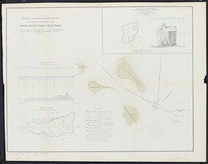
1. Boston harbor improvements at and below the narrows: and special sketch of Barrel & Kelly's Rocks Creator: Foster, John G. (John Gray), 1823-1874.; Massachusetts. Board of Harbor Commissioners Format: Maps/Atlases Collection: Massachusetts Board of Harbor and Land Commissioners Date: 1869 Institution: State Library of Massachusetts
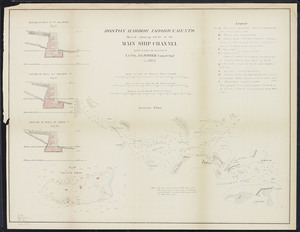
2. Boston harbor improvements: Sketch showing works in the main ship channel carried on under the direction of Lt. Col. J.G. Foster, Corps of Engrs. in 1870 Creator: Foster, John G. (John Gray), 1823-1874.; Massachusetts. Board of Harbor Commissioners Format: Maps/Atlases Collection: Massachusetts Board of Harbor and Land Commissioners Date: 1870 Institution: State Library of Massachusetts
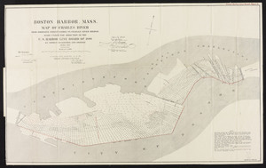
3. Boston Harbor, Mass. Map of Charles River: From Brookline Street Bridge to Charles River Bridge Creator: Board of Harbor and Land Commissioners of Massachusetts Format: Maps/Atlases Collection: Massachusetts Board of Harbor and Land Commissioners Date: 1889 Institution: State Library of Massachusetts
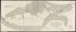
4. Boston Harbor, Mass., map of Charles River: from Brookline Street Bridge to its mouth Creator: Board of Harbor and Land Commissioners of Massachusetts Format: Maps/Atlases Collection: Massachusetts Board of Harbor and Land Commissioners Date: 1890 Institution: State Library of Massachusetts
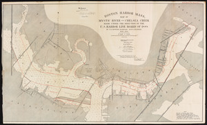
5. Boston Harbor, Mass.: map of Mystic River and Chelsea Creek Creator: Board of Harbor and Land Commissioners of Massachusetts Format: Maps/Atlases Collection: Massachusetts Board of Harbor and Land Commissioners Date: 1890 Institution: State Library of Massachusetts
6. Boston Inner Harbor, Massachusetts: from bridges to upper middle channel Creator: Board of Harbor and Land Commissioners of Massachusetts Format: Maps/Atlases Collection: Massachusetts Board of Harbor and Land Commissioners Date: 1888 Institution: State Library of Massachusetts
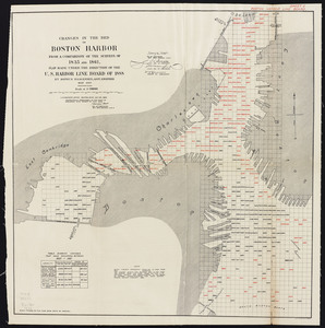
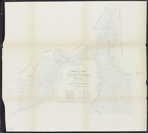
7. Changes in the bed of Boston Harbor: from a comparison of the surveys of 1835 and 1861 Creator: Board of Harbor and Land Commissioners of Massachusetts Format: Maps/Atlases Collection: Massachusetts Board of Harbor and Land Commissioners Date: 1889 Institution: State Library of Massachusetts
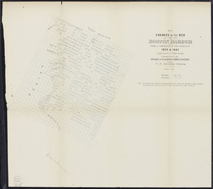
8. Changes in the bed of Boston harbor from a comparison of the surveys of 1835-61. Sheet 1. Survey of 1835 and 1847 Creator: Massachusetts. Board of Harbor Commissioners Format: Maps/Atlases Collection: Massachusetts Board of Harbor and Land Commissioners Date: 1868 Institution: State Library of Massachusetts
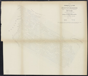
9. Changes in the bed of Boston harbor from a comparison of the surveys of 1835-61. Sheet 2. 1847 and 1861 Creator: Massachusetts. Board of Harbor Commissioners Format: Maps/Atlases Collection: Massachusetts Board of Harbor and Land Commissioners Date: 1868 Institution: State Library of Massachusetts
10. Changes in the bed of Boston harbor from a comparison of the surveys of 1835-61. Sheet 3. 1835 and 1861 Creator: Massachusetts. Board of Harbor Commissioners Format: Maps/Atlases Collection: Massachusetts Board of Harbor and Land Commissioners Date: 1868 Institution: State Library of Massachusetts