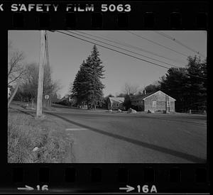
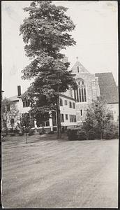
Skip to search
Skip to main content
Skip to first result
Digital Commonwealth
Folders
Sign Up / Log In
Search for
Search
Search
Search
Basic
Advanced
Explore
Map
Collections
Institutions
Formats
For Educators
Primary Source Sets
Lesson Plans
Using Primary Sources
Searching Digital Commonwealth
For Institutions
Join Digital Commonwealth
Conferences, Trainings, & Events
How to Contribute Collections
Digitization Services
Board & Committees
Frequently Asked Questions
About
About Digital Commonwealth
News & Announcements
Copyright & Terms of Use
Harmful Content Statement
Partners
API
Contact Us
Search
Search Constraints
Start Over
Save Search
Your search:
More Like
commonwealth-oai:pr76g585h
✖
Remove constraint More Like: commonwealth-oai:pr76g585h
« Prev.
|
35,461
-
35,480
of
36,027
|
Next »
Sort
by relevance
relevance
title
date (asc)
date (desc)
Number of results to display per page
20
per page
per page
10
per page
20
per page
50
per page
100
per page
View results as:
List
list view
Maps
map view
Gallery
grid view
Search Results
35461.
West Newbury Middle Rd.
35462.
West Newbury Middle Rd.
35463.
West Newbury Middle Rd.
35464.
West Newbury Middle Rd.
35465.
West Newbury training field and town pump
35466.
West Newbury training field and town pump
35467.
West Newbury training field and town pump
35468.
West Newbury training field and town pump
35469.
West Newton Street, Boston, Massachusetts, between Columbus Avenue and Tremont Street
35470.
West Newton Street, Boston, Massachusetts, between Columbus Avenue and Tremont Street
35471.
West Newton Street, Boston, Massachusetts, facing Blackstone Square
35472.
West Newton Street facing Blackstone Square, Boston, Massachusetts
35473.
West Point Island, Barnegat Bay, Lavallette, N. J.
35474.
West Roxbury, Draper house, seventeenth century
35475.
West Roxbury. Home of Robert Gould Shaw. Colonel of the First Regiment of Negro Troops in the Civil War
35476.
West Roxbury, Theodore Parker's home, built about 1800.
35477.
West Roxbury, tree shading Francis Parkman House
35478.
West Rutland Square, Boston, Massachusetts
35479.
West School, Highland Street, circa 1757, area of loaction
35480.
West side of Mill River--Williamsburg; [showing Hiram Hill house]
« Previous
Next »
1
2
…
1,770
1,771
1,772
1,773
1,774
1,775
1,776
1,777
1,778
…
1,801
1,802
Limit your search
Subject
Houses
26,820
Families
2,826
Horses
2,772
African Americans
1,979
Historic buildings
1,316
Streets
1,299
Trees
1,213
Civil rights
1,178
more
Subject
»
Place
North and Central America
29,632
United States
29,508
Massachusetts
27,698
Norfolk (county)
10,576
Needham
9,065
Suffolk (county)
5,858
Boston
5,733
Essex (county)
3,435
more
Place
»
Format
Photographs
30,199
Postcards/Cards
1,907
Documents
1,470
Prints
1,160
Newspapers
569
Manuscripts
446
Letters/Correspondence
370
Drawings/Illustrations
278
more
Format
»
Available to use
No known restrictions
16,097
Creative Commons license
10,546
Date
View distribution
Current results range from
1659
to
2023
Date range begin
Date range end
View larger »
Unknown
819
Collection
Needham Historical House Collection
8,977
Bainbridge Bunting Photograph Collection
2,840
Leon Abdalian Collection
1,716
Historical Society of Old Yarmouth Archives and Local History Collection
1,645
Frank Cousins Glass Plate Negatives Collection, 1890-1920
1,562
Tallulah Morgan v. James W. Hennigan Case File
1,166
Bill Lane Photograph Collection
953
Leslie Jones Collection
904
more
Collection
»
Institution
Boston Public Library
10,422
Needham Free Public Library
9,028
Historical Society of Old Yarmouth
1,733
Phillips Library at the Peabody Essex Museum
1,708
National Archives at Boston
1,276
Jones Library, Amherst
1,203
Newburyport Public Library
953
Arlington Historical Society
867
more
Institution
»