Skip to search
Skip to main content
Skip to first result
Digital Commonwealth
Folders
Sign Up / Log In
Search for
Search
Search
Search
Basic
Advanced
Explore
Map
Collections
Institutions
Formats
For Educators
Primary Source Sets
Lesson Plans
Using Primary Sources
Searching Digital Commonwealth
For Institutions
Join Digital Commonwealth
Conferences, Trainings, & Events
How to Contribute Collections
Digitization Services
Board & Committees
Frequently Asked Questions
About
About Digital Commonwealth
News & Announcements
Copyright & Terms of Use
Harmful Content Statement
Partners
API
Contact Us
Search
Search Constraints
Start Over
Save Search
Your search:
More Like
commonwealth-oai:pc289r29t
✖
Remove constraint More Like: commonwealth-oai:pc289r29t
« Prev. |
1
-
10
of
264
|
Next »
Sort
by relevance
relevance
title
date (asc)
date (desc)
Number of results to display per page
10
per page
per page
10
per page
20
per page
50
per page
100
per page
View results as:
List
list view
Maps
map view
Gallery
grid view
Search Results
1.
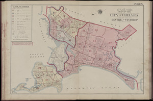
Atlas of the city of Chelsea and the towns of Revere & Winthrop, Massachusetts : from actual surveys and official plans : index...
2.
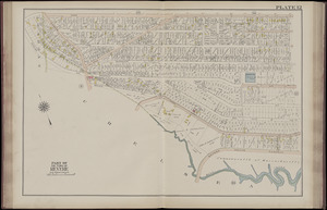
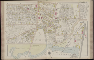
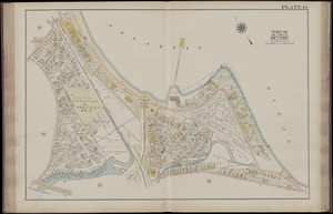
Atlas of the city of Chelsea and the towns of Revere & Winthrop, Massachusetts : from actual surveys and official plans. plate 12
3.
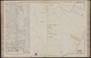
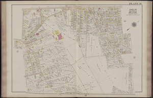
Atlas of the city of Chelsea and the towns of Revere & Winthrop, Massachusetts : from actual surveys and official plans. plate 13
4.
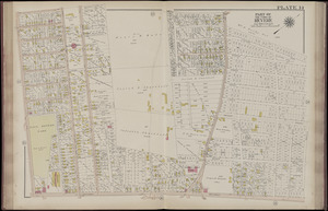
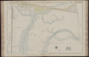
Atlas of the city of Chelsea and the towns of Revere & Winthrop, Massachusetts : from actual surveys and official plans. plate 14
5.
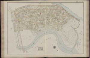
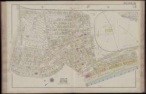
Atlas of the city of Chelsea and the towns of Revere & Winthrop, Massachusetts : from actual surveys and official plans. plate 15
6.
Atlas of the city of Chelsea and the towns of Revere & Winthrop, Massachusetts : from actual surveys and official plans. plate 16
7.
Atlas of the city of Chelsea and the towns of Revere & Winthrop, Massachusetts : from actual surveys and official plans. plate 17
8.
Atlas of the city of Chelsea and the towns of Revere & Winthrop, Massachusetts : from actual surveys and official plans. plate 18
9.
Atlas of the city of Chelsea and the towns of Revere & Winthrop, Massachusetts : from actual surveys and official plans. plate 19
10.
Atlas of the city of Chelsea and the towns of Revere & Winthrop, Massachusetts : from actual surveys and official plans. plate 20
« Previous
Next »
1
2
3
4
5
…
26
27
Limit your search
Subject
Revere (Mass.)--Maps
62
Harbors--Massachusetts--Boston--Maps
58
Landowners--Massachusetts--Revere--Maps
53
Real property--Massachusetts--Revere--Maps
53
Chelsea (Mass.)--Maps
12
Winthrop (Mass.)--Maps
12
Massachusetts--Maps
11
Boston (Mass.)--Maps
10
more
Subject
»
Place
North and Central America
264
United States
264
Massachusetts
253
Suffolk (county)
143
Boston
83
Revere
62
Plymouth (county)
31
Middlesex (county)
25
more
Place
»
Format
Maps/Atlases
221
Books
41
Photographs
2
Available to use
No known restrictions
60
Date
View distribution
Current results range from
1839
to
1916
Date range begin
Date range end
View larger »
Unknown
1
Collection
Massachusetts Board of Harbor and Land Commissioners
202
Norman B. Leventhal Map Center Collection
60
Boston and New England Maps (Collection of Distinction)
59
Urban Maps (Collection of Distinction)
59
Massachusetts Department of Transportation
1
Massachusetts Real Estate Atlases
1
Institution
State Library of Massachusetts
204
Boston Public Library
60