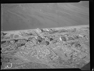
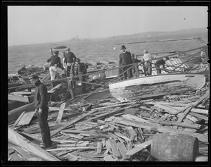
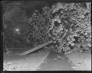
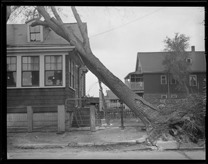
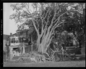
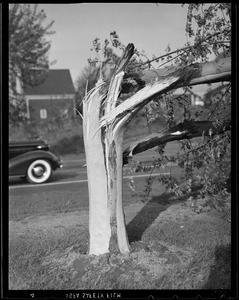
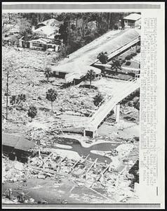
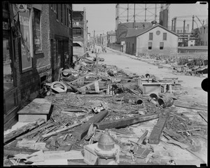
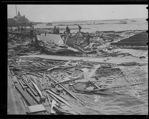
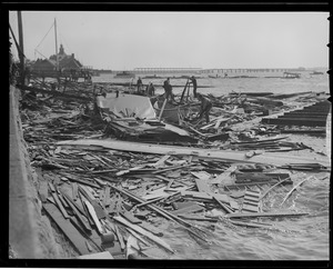
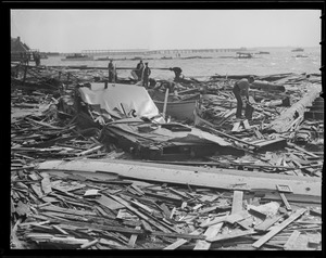
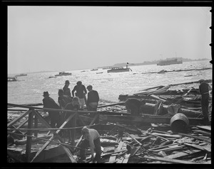
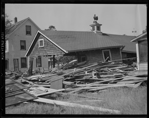
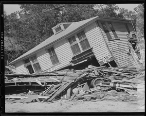
Skip to search
Skip to main content
Skip to first result
Digital Commonwealth
Folders
Sign Up / Log In
Search for
Search
Search
Search
Basic
Advanced
Explore
Map
Collections
Institutions
Formats
For Educators
Primary Source Sets
Lesson Plans
Using Primary Sources
Searching Digital Commonwealth
For Institutions
Join Digital Commonwealth
Conferences, Trainings, & Events
How to Contribute Collections
Digitization Services
Board & Committees
Frequently Asked Questions
About
About Digital Commonwealth
News & Announcements
Copyright & Terms of Use
Harmful Content Statement
Partners
API
Contact Us
Search
Search Constraints
Start Over
Save Search
Your search:
More Like
commonwealth:pv63gf66n
✖
Remove constraint More Like: commonwealth:pv63gf66n
« Prev.
|
401
-
500
of
2,001
|
Next »
Sort
by relevance
relevance
title
date (asc)
date (desc)
Number of results to display per page
100
per page
per page
10
per page
20
per page
50
per page
100
per page
View results as:
List
list view
Maps
map view
Gallery
grid view
Search Results
401.
Civil Defense in Herald Radio Car--Mrs. Irma Levine, Brookline Civil Defense worker, talking to her headquarters over CD...
402.
Clark Miller of Marblehead bailing out dingy
403.
Clean Up Fallen Trees at Capitol -- Workmen are busy this morning disposing of trees felled on the U.S. capitol grounds last...
404.
Cleaning up cemetery, Hurricane of 38
405.
Cleaning up hurricane carnage, Common St. School in background, Training Field, Chn.
406.
Cleo Batters Guadeloupe--Hurricane Cleo battered the Guadeloupe group of islands today with 115 mile an hour winds and headed...
407.
Cleo Casualties--But Not Human--These manequins were askew when hurricane Cleo winds smashed the clothing store window and rain...
408.
Cleo Downs Palms over Route 1-- A motorist out a few hours after the passing of the center of hurricane Cleo finds two of the...
409.
Cleo Goes West--Hurricane Cleo skirted Puerto Rico today and headed west northwest toward Puerto Rico today and headed west...
410.
Cleo Grounds Motorship--The 110 mile winds of hurricane Cleo drove this motorship aground in Government Cut on the causeway...
411.
Cleo Heads for Bahamas--Hurricane Cleo, winding up a 24-hour visit to Cuba, is pointed towards the southeast Florida coast and...
412.
Cleo Heads Out to Sea -- Arrow indicates path of weakened Hurricane Cleo as storm moves back over the Atlantic after coming up...
413.
Cleo Hits Cuban Coast--Hurricane Cleo today lashed the Cape Cruz peninsula of Cuba and appeared to be moving out to open...
414.
Cleo Kicks up her Heels-Cleo, the season's third tropical storm, today was making her way in open Atlantic seas, heading on a...
415.
Cleo Lands Plane in Canal-A twin engined DC-3, securely tied down at Opalacka airport, was airborn by the 125 mile an hour...
416.
Cleo Litters Street with Poles--This street in Miami, Fla., was left littered with power poles and transformers which was...
417.
Cleo Misses Islands--Arrow indicates west northwest path of Hurricane Cleo today as she moves over water between Cuba and...
418.
Cleo on the Move--Cross in solid arrow locates Hurricane Cleo 100 miles southeast of Port Au Prince,Haiti. Open arrow indicates...
419.
Cleo on the Move--Cross located approximate position of Hurricane Cleo today. Cleo, packing top winds of 80 miles an hour, was...
420.
Cleo Shatters Miami Shore Front--Guarding against possible injuries from flying glass, a policeman breaks out hanging glass in...
421.
Clings To Boat Washed Ashore-An unidentified man clings to a cabin cruiser washed ashore at Wollaston Beach.
422.
Clock from Filene's that reads "It's good shopping weather inside Filene's"
423.
Close Shot was obtained by this Houston television cameraman. He was drenched as huge wave broke against Galveston sea wall as...
424.
Close up view of a 360 degree, full-circle protractor
425.
A Close View of boats is possible for people who like to sit on the benches in South Boston and watch the pleasure craft in the...
426.
Los Cocos, D.R.: Standing before their shattered homes, victims of Hurricane Inez wave to Marine helicopter as it drops...
427.
Cohasset, Mass
428.
Collapse of Market Place During Storm Kills Many -- Seventy dead were taken from the market place at Les Cayes, Haiti. They...
429.
Collins Ave., the main drag of Miami Beach is in shambles 8/27 after the 110 mph winds of hurricane Cleo smashed into the famed...
430.
Congested Area at Swift's Beach, Wareham, where these two cottages tangle with and the wreckage of a third.
431.
Conimicut, Rhode Island, from the air, Hurricane of 38
432.
Connecting the Community; FL Insurance Crisis (Impact of Hurricanes)
433.
Connecting the Community; Homeowner Hurricane Event (Hurricane Preparation); Pensacola Historic Preservation Society's Antique...
434.
Connecting the Community; Hurricane preparation
435.
Cooking Out Is the Style since the hurricane snuffed out power, as in this Watertown scene last night. John K. Mason of...
436.
A Cool Drink is Where You Find it--Eleven- year-old Carl Wright takes advantage of a busted pipe amid the ruins of his father's...
437.
A Corpus Christi resident looks over the damage caused by a television tower that fell into a parking lot, flattening a number...
438.
Cottage showing hurricane damage
439.
Cottage Sitting on Strand.-This cottage was lifted from a lot a short distance away and placed on the strand by hurricane...
440.
Couple with umbrella walking on a flooded street
441.
Course of Atlantic Hurricane--Storm warning were ordered from West Palm Beach, Fla., to Cape Hatteras, N.C., (shaded coastal...
442.
Crystal Lake, great New England hurricane of 1938, September, 1938
443.
Cyrus Schirmer house after 1944 hurricane
444.
Cyrus Schirmer house after 1944 hurricane
445.
Cyrus Schirmer's house after 1944 hurricane
446.
Daddy's Apples Blow Down -- Suzanne Curtis, 2 1/2 years, holds one of the apples salvaged from the windfalls left in wake of...
447.
Daisy Heads Northward-Map locates hurricane Daisy, cross, about 260 miles northwest of Bermuda, as it moved north northeast...
448.
Daisy's Whereabouts--Cross on map shows approximate location late today of Daisy, season's second hurricane, with its center...
449.
Damage after the 1944 hurricane
450.
Damage along the water from the big hurricane
451.
Damage from the gale of August 1924 at rear of Jenkins Homestead, 40 Pleasant St., South Yarmouth, Mass.
452.
Damage from the gale of August 1924, corner of Main Street and Highland Ave., South Yarmouth, Mass.
453.
Damage from the gale of August 1924 in front of Methodist Church, South Yarmouth, Mass.
454.
Damage from the gale of August 1924 in rear of church, South Yarmouth, Mass.
455.
Damage from the gale of August 1924, Main Street, near Wing Ave., South Yarmouth, Mass.
456.
Damage from the gale of August 1924, Main Street, South Yarmouth, Mass., between Wing Ave. & Akin Ave.
457.
Damage from the gale of August 1924, Main Street, South Yarmouth, Mass., near Homer Ave.
458.
Damage in Lancaster Center
459.
Damage near Eastwood Cemetery
460.
Damage to Westinghouse tower
461.
Damage to Westinghouse tower
462.
Damage to Westinghouse tower
463.
Damage to Winthrop waterfront from the big storm
464.
Damage to Winthrop waterfront from the big storm
465.
Damage to Winthrop waterfront from the big storm
466.
Damage to Winthrop waterfront from the big storm
467.
Damaged boat dock with boats
468.
Damaged by Donna--The top front half of a local market is shown resting on a telephone pole after high winds from hurricane...
469.
Damaged dock with sailboats
470.
Damaged trees, Hurricane of 38
471.
Damaged trees, Hurricane of 38
472.
Damaged trees, Hurricane of 38
473.
Damaged trees, Hurricane of 38
474.
Damaged trees, Hurricane of 38
475.
Damaged trees, Hurricane of 38
476.
Damaged trees, Hurricane of 38
477.
Damaged trees, Hurricane of 38
478.
Damaged trees, Hurricane of 38
479.
Damaged Westinghouse tower
480.
Damp Stroll--Woman in Providence walks through water up to her knees on South Water St. Hurricane Donna caused abnormally high...
481.
Dangerous Crossing__ The Bridge on Route 9 over Burr Brook Was One of the Casualties of Hurricane Flood Waters in Storm...
482.
Dangerous Ladies -- Map locates path of hurricane Camille from Aug. 13 to Thursday morning, when she was 400 miles east of the...
483.
Dawn Patrol for Power - Linemen leave a Boston hotel at 6 a.m. for a long day of hurricane-repair work for the Boston Edison...
484.
[D]eath and Ruin rode in with the hurricane that swept up through New England, Sept. 21. The loss of life in these localities...
485.
The death count for Hurricane Camille is at least 16, and climbs as search parties go through debris all along the Gulf Coast...
486.
Debbie- Cross located approximate location in Gulf of Mexico of tropical storm Debbie, about 280 miles southwest of Pensacola,...
487.
Debbie on Move-Tropical storm Debbie continues to move toward the extreme northwest Florida coast.Latest reports have the storm...
488.
Debbie with Hurricane. Weather Section. Debbie
489.
Debbie’s Whereabouts--Cross gives approximate location of tropical storm Debbie which stalled just short of slamming into Gulf...
490.
Debris in street near gas tanks, Hurricane of 38
491.
Debris on shore, Hurricane of 38
492.
Debris on shore, Hurricane of 38
493.
Debris on shore, Hurricane of 38
494.
Debris on shore, Hurricane of 38
495.
Defending an open store this young boy brandishes a gun. Local merchants are protecting their businesses from posible looting...
496.
Dejected Victims--A man and his dog view wreckage of their tornado demolished home in Galveston, Wednesday. The city suffered a...
497.
Demolished house, Hurricane of 38
498.
Depending upon your point of view, Hurricane Cleo looks variously like an elephant with an unusually big tail, like a wild West...
499.
Destroyed houses, Hurricane of 38
500.
Destroyed houses, Hurricane of 38
« Previous
Next »
1
2
3
4
5
6
7
8
9
…
20
21
Limit your search
Subject
Hurricanes
1,933
New England Hurricane, 1938
385
Debris
261
Maps
214
Hurricane Edna, 1954
178
Houses
165
Trees
158
Boats
133
more
Subject
»
Place
North and Central America
767
United States
586
Massachusetts
522
Barnstable (county)
175
New England
119
Suffolk (county)
81
Essex (county)
80
Boston
75
more
Place
»
Format
Photographs
1,827
Maps/Atlases
41
Manuscripts
30
Film/Video
30
Ephemera
27
Objects/Artifacts
15
Letters/Correspondence
8
Newspapers
8
more
Format
»
Available to use
Creative Commons license
637
No known restrictions
166
Date
View distribution
Current results range from
1854
to
2016
Date range begin
Date range end
View larger »
Unknown
16
Collection
Boston Herald-Traveler Photo Morgue
943
Leslie Jones Collection
316
Press Photography from the Brearley Collection
147
Historical Society of Old Yarmouth Archives and Local History Collection
117
Civil Defense Photographs
90
Arthur Griffin Photographs
40
Barnstable Patriot Photograph Collection, 1931-1978
39
The Harvard Forest Map Collection
37
more
Collection
»
Institution
Boston Public Library
1,450
Historical Society of Old Yarmouth
117
National Archives at Boston
90
Harvard University
62
Griffin Museum of Photography
40
Cape Cod Community College
39
Special Collections and University Archives, University of Massachusetts Amherst Libraries
32
Phillips Library at the Peabody Essex Museum
27
more
Institution
»