Skip to search
Skip to main content
Skip to first result
Digital Commonwealth
Folders
Sign Up / Log In
Search for
Search
Search
Search
Basic
Advanced
Explore
Map
Collections
Institutions
Formats
For Educators
Primary Source Sets
Lesson Plans
Using Primary Sources
Searching Digital Commonwealth
For Institutions
Join Digital Commonwealth
Conferences, Trainings, & Events
How to Contribute Collections
Digitization Services
Board & Committees
Frequently Asked Questions
About
About Digital Commonwealth
News & Announcements
Copyright & Terms of Use
Harmful Content Statement
Partners
API
Contact Us
Search
Search Constraints
Start Over
Save Search
Your search:
More Like
commonwealth:m900r793g
✖
Remove constraint More Like: commonwealth:m900r793g
« Prev.
|
2,321
-
2,340
of
11,686
|
Next »
Sort
by relevance
relevance
title
date (asc)
date (desc)
Number of results to display per page
20
per page
per page
10
per page
20
per page
50
per page
100
per page
View results as:
List
list view
Maps
map view
Gallery
grid view
Search Results
2321.
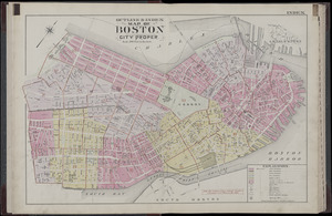
Atlas of the city of Boston, Boston proper : from actual surveys and official plans : index map
2322.
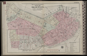
Atlas of the city of Boston, Boston proper and Back Bay : from actual surveys and official plans : index map
2323.
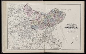
Atlas of the county of Suffolk, Massachusetts : vol. 1st including Boston proper : from actual surveys and official records :...
2324.
Ausicht von Boston : nach der natur aufgenommen
2325.
Back Bay and Parker Hill parks : Parker Hill and Jamaica parkways : Boston and Roxbury districts
2326.
Bartlett's illustrated map of Boston, or, Stranger's guide showing the public buildings, places of amusement & its'...
2327.
Block map, vicinity of Faneuil Hall, Boston : embracing Custom House, Post Office Square, Fort Hill Square, and Chamber of...
2328.
Boston
2329.
Boston
2330.
Boston
2331.
Boston
2332.
Boston, 1838
2333.
Boston and its suburban drives
2334.
[Boston and Northwestern Junction Railroad]
2335.
Boston and surroundings
2336.
Boston and vicinity
2337.
Boston and vicinity : 1893
2338.
Boston and vicinity
2339.
Boston and vicinity
2340.
Boston distance to the nearest supermarket
« Previous
Next »
1
2
…
113
114
115
116
117
118
119
120
121
…
584
585
Limit your search
Subject
Real property--Massachusetts--Boston--Maps
2,355
Boston (Mass.)--Maps
2,181
Landowners--Massachusetts--Boston--Maps
2,153
Roxbury (Boston, Mass.)--Maps
363
Dorchester (Boston, Mass.)--Maps
325
Cambridge (Mass.)--Maps
270
Brookline (Mass.)--Maps
237
Real property--Massachusetts--Cambridge--Maps
216
more
Subject
»
Place
North and Central America
8,975
United States
7,897
Massachusetts
5,088
Suffolk (county)
3,640
Boston
3,500
Europe
1,359
Middlesex (county)
622
Canada
448
more
Place
»
Format
Maps/Atlases
11,627
Manuscripts
215
Prints
56
Books
35
Objects/Artifacts
10
Drawings/Illustrations
8
Posters
4
Available to use
No known restrictions
11,484
Creative Commons license
68
Date
View distribution
Current results range from
1482
to
2023
Date range begin
Date range end
View larger »
Unknown
3
Collection
Norman B. Leventhal Map & Education Center Collection
11,413
Boston and New England Maps (Collection of Distinction)
5,303
Urban Maps (Collection of Distinction)
5,032
Maritime Charts and Atlases (Collection of Distinction)
1,081
American Revolutionary War-Era Maps (Collection of Distinction)
626
Boston Redevelopment Authority Collection
248
Historic Maps
49
Massachusetts Real Estate Atlases
38
more
Collection
»
Institution
Boston Public Library
11,552
State Library of Massachusetts
54
Salem State University Archives and Special Collections
49
Private Collection
21
American Antiquarian Society
9
Boston Athenaeum
1


![[Boston and Northwestern Junction Railroad]](https://bpldcassets.blob.core.windows.net/derivatives/images/commonwealth:x059cc74n/image_thumbnail_300.jpg)


