Search


![Plan of lands on the Back Bay belonging to the Boston Water Power Co., the Commonwealth and other parthies [i.e. parties], showing the system of streets, grades and sewers as laid out and recommended by the Back Bay Commissioners](https://bpldcassets.blob.core.windows.net/derivatives/images/commonwealth:1257bb305/image_thumbnail_300.jpg)
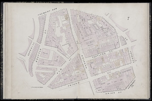
![[Plan of lots in Chinatown (Boston), between Avery and Eliot Streets, and Tremont Street and Harrison Avenue]](https://bpldcassets.blob.core.windows.net/derivatives/images/commonwealth:cj82kz565/image_thumbnail_300.jpg)


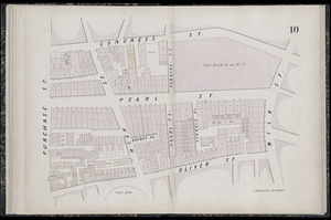
![[Plan of real estate on Pearl Street, Boston]](https://bpldcassets.blob.core.windows.net/derivatives/images/commonwealth:9s161d705/image_thumbnail_300.jpg)

Limit your search
- North and Central America8,975
- United States7,897
- Massachusetts5,088
- Suffolk (county)3,640
- Boston3,500
- Europe1,359
- Middlesex (county)622
- Canada448
- Norman B. Leventhal Map & Education Center Collection11,413
- Boston and New England Maps (Collection of Distinction)5,303
- Urban Maps (Collection of Distinction)5,032
- Maritime Charts and Atlases (Collection of Distinction)1,081
- American Revolutionary War-Era Maps (Collection of Distinction)626
- Boston Redevelopment Authority Collection248
- Historic Maps49
- Massachusetts Real Estate Atlases38