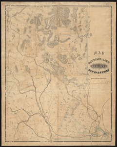
Skip to search
Skip to main content
Skip to first result
Digital Commonwealth
Folders
Sign Up / Log In
Search for
Search
Search
Search
Basic
Advanced
Explore
Map
Collections
Institutions
Formats
For Educators
Primary Source Sets
Lesson Plans
Using Primary Sources
Searching Digital Commonwealth
For Institutions
Join Digital Commonwealth
Conferences, Trainings, & Events
How to Contribute Collections
Digitization Services
Board & Committees
Frequently Asked Questions
About
About Digital Commonwealth
News & Announcements
Copyright & Terms of Use
Harmful Content Statement
Partners
API
Contact Us
Search
Search Constraints
Start Over
Save Search
Your search:
More Like
commonwealth:cj82km99w
✖
Remove constraint More Like: commonwealth:cj82km99w
« Prev. |
1
-
20
of
11,400
|
Next »
Sort
by relevance
relevance
title
date (asc)
date (desc)
Number of results to display per page
20
per page
per page
10
per page
20
per page
50
per page
100
per page
View results as:
List
list view
Maps
map view
Gallery
grid view
Search Results
1.
Map of the country copied from Hale's map of N. E. with railroad route from Boston to Lake Champlain : through Keene, N. H
2.
Map of the rail road from Boston to Stanstead
3.
Map showing the relative distances of Porsmouth [i.e. Portsmouth] and Boston from Concord & Manchester, N.H
4.
Complete map of Vermont showing highways & natural features with an index of all cities, villages, post-offices and railroad...
5.
Railroad Commissioners' map of the State of Vermont
6.
Map of the mountain and lake regions of New-Hampshire with rail-road routes
7.
Map showing the proposed line of the Manchester Rail Road as petitioned for by S.D. Bell & others
8.
Map of Maine, New Hampshire, and Vermont : compiled from the latest authorities
9.
Map of Maine, New Hampshire and Vermont, from the most authentic sources
10.
Rand McNally official 1924 auto trails map Maine ; Rand McNally official 1924 auto trails map New Hampshire, Vermont
11.
County Map of the States of New York, New Hampshire, Vermont, Massachusetts, Rhode Island, and Connecticut.
12.
Map of the northern part of New England : compiled for Pres't. Dwight's travels
13.
A map of the states of New Hampshire and Vermont
14.
New Hampshire & Vermont
15.
New Hampshire, Vermont, &c
16.
Map & profiles of the Vt. Central and Vt. and Canada Railroads
17.
Calvert's map of the lake region in New Hampshire, U.S.A.
18.
Map of the White Mountains, N.H
19.
Colton's Vermont
20.
An improved map of Vermont : compiled from the latest authorities
« Previous
Next »
1
2
3
4
5
…
569
570
Limit your search
Subject
Real property--Massachusetts--Boston--Maps
2,278
Landowners--Massachusetts--Boston--Maps
2,117
Boston (Mass.)--Maps
1,969
Roxbury (Boston, Mass.)--Maps
351
Dorchester (Boston, Mass.)--Maps
317
Cambridge (Mass.)--Maps
266
Brookline (Mass.)--Maps
236
Real property--Massachusetts--Cambridge--Maps
216
more
Subject
»
Place
North and Central America
8,689
United States
7,604
Massachusetts
4,956
Suffolk (county)
3,345
Boston
3,205
Europe
1,359
Middlesex (county)
618
Canada
449
more
Place
»
Format
Maps/Atlases
11,341
Manuscripts
215
Prints
56
Books
35
Objects/Artifacts
10
Drawings/Illustrations
8
Posters
4
Available to use
No known restrictions
11,318
Creative Commons license
47
Date
View distribution
Current results range from
1482
to
2023
Date range begin
Date range end
View larger »
Collection
Norman B. Leventhal Map & Education Center Collection
11,386
Boston and New England Maps (Collection of Distinction)
5,125
Urban Maps (Collection of Distinction)
4,857
Maritime Charts and Atlases (Collection of Distinction)
1,081
American Revolutionary War-Era Maps (Collection of Distinction)
625
Boston Redevelopment Authority Collection
87
American Antiquarian Society Collection
9
Historic Maps
2
more
Collection
»
Institution
Boston Public Library
11,386
American Antiquarian Society
9
Salem State University Archives and Special Collections
2
Massachusetts Historical Society
1
Phillips Academy
1
State Library of Massachusetts
1