Skip to search
Skip to main content
Skip to first result
Digital Commonwealth
Folders
Sign Up / Log In
Search for
Search
Search
Search
Basic
Advanced
Explore
Map
Collections
Institutions
Formats
For Educators
Primary Source Sets
Lesson Plans
Using Primary Sources
Searching Digital Commonwealth
For Institutions
Join Digital Commonwealth
Conferences, Trainings, & Events
How to Contribute Collections
Digitization Services
Board & Committees
Frequently Asked Questions
About
About Digital Commonwealth
News & Announcements
Copyright & Terms of Use
Harmful Content Statement
Partners
API
Contact Us
Search
Search Constraints
Start Over
Save Search
Your search:
More Like
commonwealth:8s45qz88h
✖
Remove constraint More Like: commonwealth:8s45qz88h
« Prev. |
1
-
20
of
3,031
|
Next »
Sort
by date (asc)
relevance
title
date (asc)
date (desc)
Number of results to display per page
20
per page
per page
10
per page
20
per page
50
per page
100
per page
View results as:
List
list view
Maps
map view
Gallery
grid view
Search Results
1.
A south-east view of the City of Boston in North America
2.
To the merchants of Boston this view of the light house is most humbly presented by their humble servt. Wm. Burgis
3.
A south-east view of the City of Boston in North America
4.
Vindicibvs.et.protectoribvs bonarvm.artivm I.B.Piranesivs
5.
View of the Long Warf & port of the harbour of Boston in New England America
6.
View of the Long Warf & port of the harbour of Boston in New England America
7.
Boston. Perspective. View of Boston Harbor and the British fleet, 1768
8.
L'entrée au Port de Boston, dans L'Amérique
9.
A south west view of the lighthouse, situate at the entrance of Boston Harbour
10.
"Ingresso del porto di Boston in America"
11.
New York
12.
View of Boston, from the bay
13.
Tower of London, with ships at anchor in the Thames River
14.
China Sea
15.
Charlestown Navy Yard about 1826. Showing Bunker Hill
16.
This chart, intended as an accompaniment to the book of directions for navigating to, from, and in the East Indies
17.
A chart of the Bay of Biscay, with various additions & improvements from the surveys of Tofino, Mechain, & others
18.
The north eastern coast of North America, New York to Cape Canso, including Sable Island
19.
Harbor at Hong Kong
20.
Seaport of Joppa
« Previous
Next »
1
2
3
4
5
…
151
152
Limit your search
Subject
Harbors
2,915
Boats
953
Piers & wharves
531
Islands
272
Waterfronts
236
Ships
235
Harbors--Provincetown--Mass
201
Provincetown (Mass.)--History--20th century
184
more
Subject
»
Place
North and Central America
2,653
United States
2,594
Massachusetts
2,185
Essex (county)
763
Barnstable (county)
643
Suffolk (county)
378
Boston Harbor
276
Newburyport
268
more
Place
»
Format
Photographs
1,827
Postcards/Cards
621
Prints
241
Maps/Atlases
179
Documents
103
Newspapers
54
Paintings
33
Drawings/Illustrations
26
more
Format
»
Available to use
No known restrictions
1,005
Creative Commons license
992
Date
View distribution
Current results range from
1723
to
2002
Date range begin
Date range end
View larger »
Unknown
240
Collection
Boston Pictorial Archive (Collection of Distinction)
372
Falmouth Public Library Historical Postcard Collection
313
Bill Lane Photograph Collection
310
Samuel Chamberlain Photograph Negatives Collection, 1928-1971, undated
297
Tichnor Brothers Postcard Collection
214
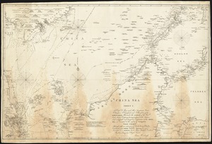
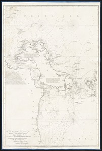
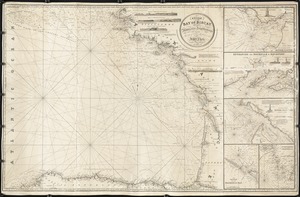
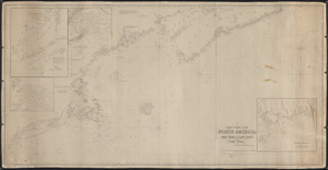
Nautical Chart Collection of the Chatham Historical Society
167
John Dowd Althea Boxell Collection
161
Arthur Griffin Photographs
118
more
Collection
»
Institution
Boston Public Library
1,224
Phillips Library at the Peabody Essex Museum
317
Falmouth Public Library
313
Newburyport Public Library
310
Provincetown History Preservation Project
210
Atwood Museum of the Chatham Historical Society
167
Griffin Museum of Photography
118
New Bedford Free Public Library
84
more
Institution
»