Skip to search
Skip to main content
Skip to first result
Digital Commonwealth
Folders
Sign Up / Log In
Search for
Search
Search
Search
Basic
Advanced
Explore
Map
Collections
Institutions
Formats
For Educators
Primary Source Sets
Lesson Plans
Using Primary Sources
Searching Digital Commonwealth
For Institutions
Join Digital Commonwealth
Conferences, Trainings, & Events
How to Contribute Collections
Digitization Services
Board & Committees
Frequently Asked Questions
About
About Digital Commonwealth
News & Announcements
Copyright & Terms of Use
Harmful Content Statement
Partners
API
Contact Us
Search
Search Constraints
Start Over
Save Search
Your search:
More Like
commonwealth:70796k59f
✖
Remove constraint More Like: commonwealth:70796k59f
« Prev.
|
441
-
460
of
789
|
Next »
Sort
by relevance
relevance
title
date (asc)
date (desc)
Number of results to display per page
20
per page
per page
10
per page
20
per page
50
per page
100
per page
View results as:
List
list view
Maps
map view
Gallery
grid view
Search Results
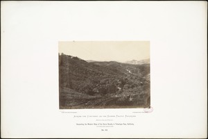
441.
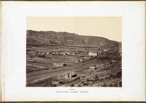
Coalville, Weber Valley.
442.
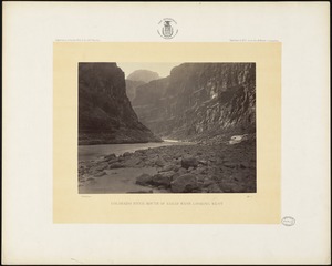
Colorado River, mouth of Kanab Wash, looking west
443.
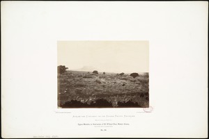
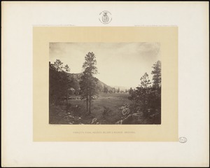
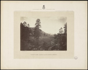
Cooley's Park, Sierra Blanca Range, Arizona
444.
Cooley's Park, Sierra Blanca Range, Arizona
445.
Cooley's Ranch, 10 miles east of Camp Apache, Arizona.
446.
Coyotero Apache scouts, at Apache Lake
447.
Cross Mountain, Western Arizona, 1,350 miles from Missouri River.
448.
Crossing of the Grasshopper, in Kansas, 50 miles west of Missouri River.
449.
Crossing of the Line at Tecalote Creek, New Mexico, north of Anton Chico, 775 miles west of Missouri River.
450.
Crossing of the Republican, in Kansas, 136 miles west of Missouri River.
451.
Crossing of the Sierra Nevadas, California; "Tehachapa Pass," 1,720 miles west of Missouri River.
452.
Crossing of the Sierras at Tehachapa Pass, California,
453.
Curicante [i.e. Curecanti] Needle, Black Cañon of the Gunnison
454.
Cygnus Mountain, on Head-waters of Bill Williams' River, Western Arizona, 1,350 miles west of Missouri River.
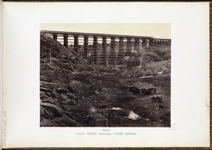
455.
Dale Creek Bridge, from above.
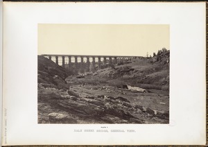
456.
Dale Creek Bridge, general view.
457.
Decesending the Western Slope of the Sierra Nevada, in Tehachapa Pass, California, 1,710 miles from Missouri River.
458.
Depot of Pacific Railroad, St. Louis, Mo.
459.
Devil's Gate, Dale Creek Canon.
460.
Devil's Gate, Weber Canon.
« Previous
Next »
1
2
…
19
20
21
22
23
24
25
26
27
…
39
40
Limit your search
Subject
Indians of North America
334
Indigenous peoples
140
Trans-Mississippi and International Exposition (1898 : Omaha, Neb.)
113
Mountains
80
Union Pacific Railroad Company
50
Rivers
45
Rock formations
32
Trees
31
more
Subject
»
Place
North and Central America
541
United States
496
Massachusetts
103
Arizona
76
California
75
Colorado
60
New Mexico
56
Western United States
50
more
Place
»
Format
Photographs
740
Prints
20
Objects/Artifacts
7
Books
6
Ephemera
5
Documents
4
Manuscripts
4
Paintings
4
more
Format
»
Available to use
No known restrictions
599
Creative Commons license
17
Date
View distribution
Current results range from
1765
to
2019
Date range begin
Date range end
View larger »
Unknown
2
Collection
Photographs of the American West
570
Leslie Jones Collection
96
Stereograph Collection
56
Arthur Griffin Photographs
36
Plymouth Tercentenary Photographs
9
Social and Political Cartoons
9
Art and Artifacts Collection
7
Boston Children’s Museum Lantern Slides
6
more
Collection
»
Institution
Boston Public Library
685
Griffin Museum of Photography
36
Historical Society of Old Yarmouth
9
Plymouth Public Library
9
Nahant Public Library
7
Boston Children's Museum
6
Amherst College Archives & Special Collections
5
Arlington Historical Society
4
more
Institution
»
![Curicante [i.e. Curecanti] Needle, Black Cañon of the Gunnison](https://bpldcassets.blob.core.windows.net/derivatives/images/commonwealth:b5647q50m/image_thumbnail_300.jpg)