Search
Limit your search
- Lakes & ponds3,790
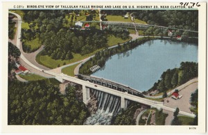
- Bridges3,271
- Motels2,665
- Beaches2,180
- Cities & towns2,151
- Hotels2,076
- Rivers1,558
- Boats1,546
- North and Central America29,973
- United States29,285
- Massachusetts5,771
- Florida3,053
- New Jersey2,468
- New York1,889
- Pennsylvania1,551
- Suffolk (county)1,344
- Postcards/Cards28,386
- Photographs4,133
- Prints523
- Ephemera59
- Paintings44
- Manuscripts37
- Posters34
- Albums/Scrapbooks31
- Tichnor Brothers Postcard Collection27,831
- Bill Lane Photograph Collection364
- Stereograph Collection297
- Leslie Jones Collection263
- Leon Abdalian Collection257
- Historical Society of Old Newbury, Snow Historical Photograph Collection224
- Historical Society of Old Yarmouth Archives and Local History Collection217
- College Archives Digital Collections213