Skip to search
Skip to main content
Skip to first result
Digital Commonwealth
Folders
Sign Up / Log In
Search for
Search
Search
Search
Basic
Advanced
Explore
Map
Collections
Institutions
Formats
For Educators
Primary Source Sets
Lesson Plans
Using Primary Sources
Searching Digital Commonwealth
For Institutions
Join Digital Commonwealth
Conferences, Trainings, & Events
How to Contribute Collections
Digitization Services
Board & Committees
Frequently Asked Questions
About
About Digital Commonwealth
News & Announcements
Copyright & Terms of Use
Harmful Content Statement
Partners
API
Contact Us
Search
Search Constraints
Start Over
Save Search
Your search:
More Like
commonwealth:25152n463
✖
Remove constraint More Like: commonwealth:25152n463
« Prev.
|
621
-
640
of
726
|
Next »
Sort
by relevance
relevance
title
date (asc)
date (desc)
Number of results to display per page
20
per page
per page
10
per page
20
per page
50
per page
100
per page
View results as:
List
list view
Maps
map view
Gallery
grid view
Search Results
621.
Plan of Upton made by Nahum W. Holbrook, dated 1831
622.
Plan of Upton, surveyor's name not given, dated May 19, 1795.
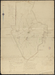
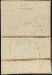
623.
Plan of Uxbridge made by Abiel Jaques, dated 1830
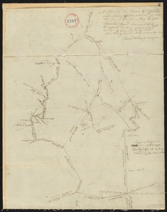
624.
Plan of Uxbridge, made by Frederic Taft, dated May 25, 1795.
625.
Plan of Vassalborough surveyed by Ephraim Ballard, dated January, 1795.
626.
Plan of Vinalhaven made by J. Vinal, in 1786. Scale 200rds to 1".
627.
Plan of Waldoborough surveyed by Ebenezer Jennison, dated 1794-5.
628.
Plan of Wales (South Brimfield), made by Daniel Wright, dated April 1, 1795.
629.
Plan of Wales surveyed by James Shurtleff, dated 1794.
630.
Plan of Wales, surveyor's name not given, dated 1830
631.
Plan of Walpole made by Elijah Hewins, dated December, 1832
632.
Plan of Walpole made by John G. Hales, dated 1831
633.
Plan of Walpole, surveyor's name not given, dated October 1794.
634.
Plan of Waltham made by John G Hales, dated 1831
635.
Plan of Ward (Auburn) made by Hervey Peirce, dated February 1831
636.
Plan of Ward (Auburn), surveyed by Joseph Stone, dated November 6, 1794.
637.
Plan of Ware, surveyor's name not given, dated 1830
638.
Plan of Ware, surveyor's name not given, dated April 1795.
639.
Plan of Wareham, surveyor's name not given, dated 1795.
640.
Plan of Wareham, surveyor's name not given, dated 1830
« Previous
Next »
1
2
…
28
29
30
31
32
33
34
35
36
37
Limit your search
Place
North and Central America
724
United States
723
Massachusetts
296
Maine
128
Worcester (county)
109
Middlesex (county)
77
Franklin (county)
61
Berkshire (county)
59
more
Place
»
Format
Maps/Atlases
726
Available to use
No known restrictions
726
Date
View distribution
Current results range from
1786
to
1898
Date range begin
Date range end
View larger »
Collection
Town plans, 1794
403
Town plans, 1830
323
Institution
Massachusetts Archives
726