Skip to search
Skip to main content
Skip to first result
Digital Commonwealth
Folders
Sign Up / Log In
Search for
Search
Search
Search
Basic
Advanced
Explore
Map
Collections
Institutions
Formats
For Educators
Primary Source Sets
Lesson Plans
Using Primary Sources
Searching Digital Commonwealth
For Institutions
Join Digital Commonwealth
Conferences, Trainings, & Events
How to Contribute Collections
Digitization Services
Board & Committees
Frequently Asked Questions
About
About Digital Commonwealth
News & Announcements
Copyright & Terms of Use
Harmful Content Statement
Partners
API
Contact Us
Search
Search Constraints
Start Over
Save Search
Your search:
More Like
commonwealth:25152n463
✖
Remove constraint More Like: commonwealth:25152n463
« Prev.
|
541
-
560
of
726
|
Next »
Sort
by relevance
relevance
title
date (asc)
date (desc)
Number of results to display per page
20
per page
per page
10
per page
20
per page
50
per page
100
per page
View results as:
List
list view
Maps
map view
Gallery
grid view
Search Results
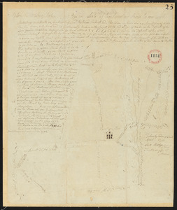
541.
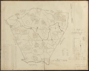
Plan of Shelburne made by E. S. Darling, dated October 1830
542.
Plan of Shelburne, surveyor's name not given, datd November 1794.
543.
Plan of Sherborn made by Dalton Goulding, dated 1831
544.
Plan of Sherborn, surveyor's name not given, dated September 1794.
545.
Plan of Shirley made by Caleb Butler, dated 1830
546.
Plan of Shrewsbury made by Henry Snow, dated 1830
547.
Plan of Shrewsbury surveyed by Silas Keyes, dated 1794-5.
548.
Plan of Shutesbury made by E. S. Darling, dated October 1830
549.
Plan of Shutesbury, surveyor's name not given, dated April 1795.
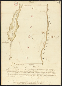
550.
Plan of Sidney surveyed by Sylvester Moore and Ephraim Ballard, dated March 1795.
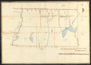
551.
Plan of six townships in Ranges 1 and 2 north of Plymouth Claim, surveyor's name not given, dated February 15, 1794.
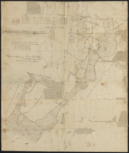
552.
Plan of Somerset, surveyor's name not given, dated December 1830
553.
Plan of Somerset, surveyor's name not given, dated May 23, 1795.
554.
Plan of South Hadley made by Daniel Paine, dated March 1831
555.
Plan of South Hadley, surveyor's name not given, dated November 1794.
556.
Plan of South Reading (Wakefield) made by John G. Hales, dated September 1830
557.
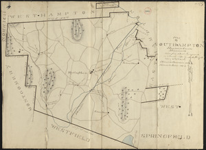
Plan of Southampton made by Justus Dwight, dated November 1830
558.
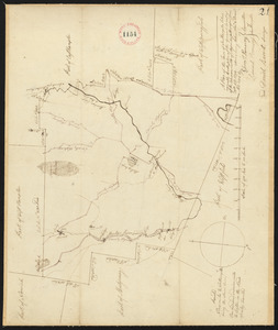
Plan of Southampton surveyed by Daniel Barrett, dated December, 1794.
559.
Plan of Southborough made by Larkin Newton, dated 1831
560.
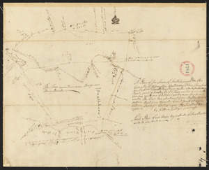
Plan of Southborough surveyed by Nathan Bridges dated December 15, 1794.
« Previous
Next »
1
2
…
24
25
26
27
28
29
30
31
32
…
36
37
Limit your search
Place
North and Central America
724
United States
723
Massachusetts
297
Maine
128
Worcester (county)
109
Middlesex (county)
77
Franklin (county)
61
Berkshire (county)
59
more
Place
»
Format
Maps/Atlases
726
Available to use
No known restrictions
726
Date
View distribution
Current results range from
1786
to
1898
Date range begin
Date range end
View larger »
Collection
Town plans, 1794
403
Town plans, 1830
323
Institution
Massachusetts Archives
726