Skip to search
Skip to main content
Skip to first result
Digital Commonwealth
Folders
Sign Up / Log In
Search for
Search
Search
Search
Basic
Advanced
Explore
Map
Collections
Institutions
Formats
For Educators
Primary Source Sets
Lesson Plans
Using Primary Sources
Searching Digital Commonwealth
For Institutions
Join Digital Commonwealth
Conferences, Trainings, & Events
How to Contribute Collections
Digitization Services
Board & Committees
Frequently Asked Questions
About
About Digital Commonwealth
News & Announcements
Copyright & Terms of Use
Harmful Content Statement
Partners
API
Contact Us
Search
Search Constraints
Start Over
Save Search
Your search:
More Like
commonwealth:25152n44j
✖
Remove constraint More Like: commonwealth:25152n44j
« Prev.
|
701
-
720
of
726
|
Next »
Sort
by date (asc)
relevance
title
date (asc)
date (desc)
Number of results to display per page
20
per page
per page
10
per page
20
per page
50
per page
100
per page
View results as:
List
list view
Maps
map view
Gallery
grid view
Search Results
701.
Plan of Windsor made by Elias J. Baldwin, dated October 1831
702.
Plan of Wilmington made by Edmund Parker, dated October 17, 1831
703.
Plan of Douglas made by Warren Humes, dated October 20, 1831
704.
Plan of Holden made by Charles Chaffin, dated October 20, 1831
705.
Plan of Blandford made by Luke Barber, dated October 24, 1831
706.
Plan of Warren (Western), surveyor's name not given, dated October 24, 1831
707.
Plan of Becket made by Luke Barber, dated October 26, 1831
708.
Plan of Townsend, surveyor's name not given, dated October 26, 1831
709.
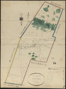
Plan of Dalton made by M. H. Eames, dated October 27, 1831
710.
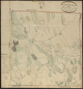
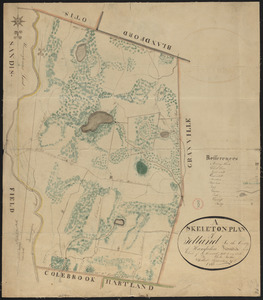
Plan of Tolland made by Luke Barber, dated September 27, 1831
711.
Plan of Dracut made by B. F. Varnum, dated October 31, 1831
712.
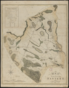
Plan of Danvers made by John W. Proctor, dated 1832
713.
Plan of Salem made by Jonathan P. Saunders, dated 1832
714.
Plan of Walpole made by Elijah Hewins, dated December, 1832
715.
Plan of Duxbury made by John Ford, Jr., dated 1833
716.
Plan of Elizabeth Islands (Naushon, Pasque, and the Wepeckalt Islands) made by Henry H. Crapo, dated 1837
717.
Plan of No Town (Princeton), surveyor's name not given, dated 1838
718.
Plan of Westminster (No Town) made by Caleb Dana, dated 1838
719.
Plan of Hawley made by John Tobey, dated March, 1839
720.
Plan of Charlemont (Zoar) made by John Tobey, dated June 1839
« Previous
Next »
1
2
…
32
33
34
35
36
37
Limit your search
Place
North and Central America
724
United States
723
Massachusetts
295
Maine
128
Worcester (county)
108
Middlesex (county)
77
Franklin (county)
61
Berkshire (county)
59
more
Place
»
Format
Maps/Atlases
726
Available to use
No known restrictions
726
Date
View distribution
Current results range from
1786
to
1898
Date range begin
Date range end
View larger »
Collection
Town plans, 1794
403
Town plans, 1830
323
Institution
Massachusetts Archives
726