Skip to search
Skip to main content
Skip to first result
Digital Commonwealth
Folders
Sign Up / Log In
Search for
Search
Search
Search
Basic
Advanced
Explore
Map
Collections
Institutions
Formats
For Educators
Primary Source Sets
Lesson Plans
Using Primary Sources
Searching Digital Commonwealth
For Institutions
Join Digital Commonwealth
Conferences, Trainings, & Events
How to Contribute Collections
Digitization Services
Board & Committees
Frequently Asked Questions
About
About Digital Commonwealth
News & Announcements
Copyright & Terms of Use
Harmful Content Statement
Partners
API
Contact Us
Search
Search Constraints
Start Over
Save Search
Your search:
More Like
commonwealth:2227np080
✖
Remove constraint More Like: commonwealth:2227np080
« Prev.
|
661
-
680
of
726
|
Next »
Sort
by relevance
relevance
title
date (asc)
date (desc)
Number of results to display per page
20
per page
per page
10
per page
20
per page
50
per page
100
per page
View results as:
List
list view
Maps
map view
Gallery
grid view
Search Results
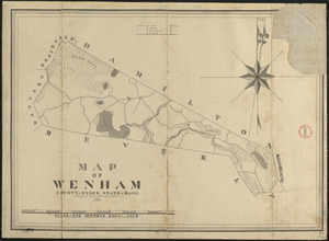
661.
Plan of Wenham made by Philander Anderson, dated 1831
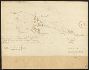
662.
Plan of Wenham surveyed by Richard Dodge, dated January, 1795.
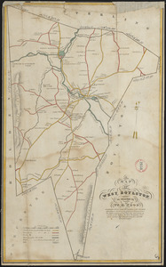
663.
Plan of West Boylston made by William H. Wood, dated September 1830
664.
Plan of West Bridgewater, surveyor's name not given, dated 1830
665.
Plan of West Bridgewater, surveyor's name not given, dated 1831
666.
Plan of West Newbury made by Philander Anderson, dated 1830
667.
Plan of West Springfield made by J. Lathrop, dated August 1831
668.
Plan of West Springfield made by J. Lathrop, dated August 1831
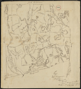
669.
Plan of West Springfield, surveyor's name not given, dated May 20, 1795.
670.
Plan of West Stockbridge made by B. H. Lewis, dated 1831
671.
Plan of West Stockbridge surveyed by David Fairchild, dated October, 1794.
672.
Plan of Westborough made by Nahum Fisher, dated 1830
673.
Plan of Westborough surveyed by Nathan Fisher, dated October, 1794.
674.
Plan of Westfield made by Allen, D. E., dated 1831
675.
Plan of Westfield, surveyor's name not given, dated November 1794.
676.
Plan of Westford made by John G. Hales, dated 1831
677.
Plan of Westford, surveyor's name not given, dated May 1795.
678.
Plan of Westhampton surveyed by Jonathan Clark, dated June 1, 1795.
679.
Plan of Westhampton, surveyor's name not given, dated 1831
680.
Plan of Westminster (No Town) made by Caleb Dana, dated 1838
« Previous
Next »
1
2
…
30
31
32
33
34
35
36
37
Limit your search
Place
North and Central America
724
United States
723
Massachusetts
295
Maine
128
Worcester (county)
109
Middlesex (county)
76
Franklin (county)
61
Berkshire (county)
59
more
Place
»
Format
Maps/Atlases
726
Available to use
No known restrictions
726
Date
View distribution
Current results range from
1786
to
1898
Date range begin
Date range end
View larger »
Collection
Town plans, 1794
402
Town plans, 1830
324
Institution
Massachusetts Archives
726