Skip to search
Skip to main content
Skip to first result
Digital Commonwealth
Folders
Sign Up / Log In
Search for
Search
Search
Search
Basic
Advanced
Explore
Map
Collections
Institutions
Formats
For Educators
Primary Source Sets
Lesson Plans
Using Primary Sources
Searching Digital Commonwealth
For Institutions
Join Digital Commonwealth
Conferences, Trainings, & Events
How to Contribute Collections
Digitization Services
Board & Committees
Frequently Asked Questions
About
About Digital Commonwealth
News & Announcements
Copyright & Terms of Use
Harmful Content Statement
Partners
API
Contact Us
Search
Search Constraints
Start Over
Save Search
Your search:
More Like
commonwealth:2227nm788
✖
Remove constraint More Like: commonwealth:2227nm788
« Prev.
|
241
-
260
of
726
|
Next »
Sort
by relevance
relevance
title
date (asc)
date (desc)
Number of results to display per page
20
per page
per page
10
per page
20
per page
50
per page
100
per page
View results as:
List
list view
Maps
map view
Gallery
grid view
Search Results
241.
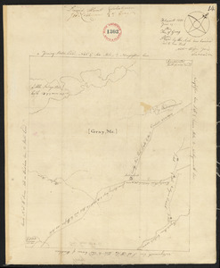
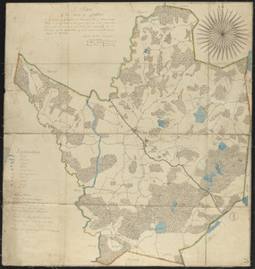
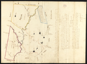
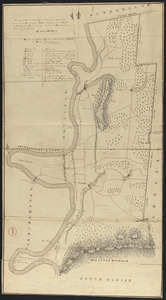
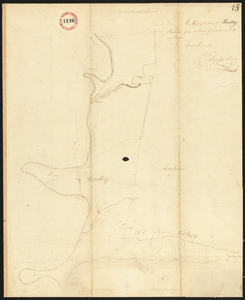
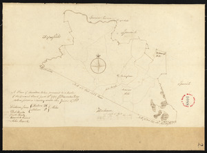
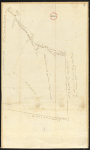
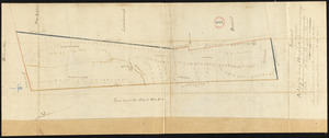
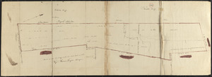
Plan of Gray, Me. (New Boston), made by Nathaniel Wilson, dated June 19, 1795.
242.
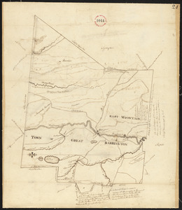
Plan of Great Barrington made by David Fairchild, dated November, 1794.
243.
Plan of Great Barrington, surveyor's name not given, dated 1830
244.
Plan of Greene, Maine, surveyor's name not given, dated March, 1795.
245.
Plan of Greenfield, made by D Hoit, Jr., dated May 13, 1795.
246.
Plan of Greenfield made by Elisha Root, dated 1830
247.
Plan of Greenwich, made by David Pratt, dated 1794-5.
248.
Plan of Greenwich made by E. S. Darling, dated October, 1830
249.
Plan of Groton made by Caleb Butler, dated 1830
250.
Plan of Groton, Pepperell and Shirley, made by Oliver Prescott, Jr., dated September, 1794.
251.
Plan of Hadley made by Arthur W. Hoyt, dated 1830
252.
Plan of Hadley surveyed by J Denison, dated April 30, 1795.
253.
Plan of Halifax made by Samuel Thompson, dated 1830
254.
Plan of Halifax, surveyor's name not given, dated June 1, 1795.
255.
Plan of Hallowell surveyed by Ephraim Ballard and Sylvester Moore, dated March, 1795.
256.
Plan of Hamilton made by A. Brown, dated 1831
257.
Plan of Hamilton, made by Barnabas Dodge, dated 1794-5.
258.
Plan of Hampden, Me., surveyor's name not given, dated May 16, 1795.
259.
Plan of Hancock by William Douglas, dated November, 1794.
260.
Plan of Hancock made by Rodman Hazard, dated November 20, 1830
« Previous
Next »
1
2
…
9
10
11
12
13
14
15
16
17
…
36
37
Limit your search
Place
North and Central America
724
United States
723
Massachusetts
296
Maine
128
Worcester (county)
109
Middlesex (county)
76
Franklin (county)
61
Berkshire (county)
59
more
Place
»
Format
Maps/Atlases
726
Available to use
No known restrictions
726
Date
View distribution
Current results range from
1786
to
1898
Date range begin
Date range end
View larger »
Collection
Town plans, 1794
402
Town plans, 1830
324
Institution
Massachusetts Archives
726