Skip to search
Skip to main content
Skip to first result
Digital Commonwealth
Folders
Sign Up / Log In
Search for
Search
Search
Search
Basic
Advanced
Explore
Map
Collections
Institutions
Formats
For Educators
Primary Source Sets
Lesson Plans
Using Primary Sources
Searching Digital Commonwealth
For Institutions
Join Digital Commonwealth
Conferences, Trainings, & Events
How to Contribute Collections
Digitization Services
Board & Committees
Frequently Asked Questions
About
About Digital Commonwealth
News & Announcements
Copyright & Terms of Use
Harmful Content Statement
Partners
API
Contact Us
Search
Search Constraints
Start Over
Save Search
Your search:
More Like
commonwealth:2227nh08z
✖
Remove constraint More Like: commonwealth:2227nh08z
« Prev.
|
651
-
700
of
726
|
Next »
Sort
by date (asc)
relevance
title
date (asc)
date (desc)
Number of results to display per page
50
per page
per page
10
per page
20
per page
50
per page
100
per page
View results as:
List
list view
Maps
map view
Gallery
grid view
Search Results
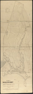
651.
Plan of Westport made by Silvanus Bourne dated 1831
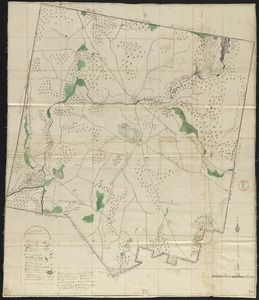
652.
Plan of Winchendon made by Elias Whitney, dated January 1831
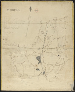
653.
Plan of Woburn made by Bartholomew Richardson, dated 1831
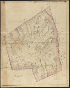
654.
Plan of Worcester made by H. Stebbins, dated 1831
655.
Plan of Mt. Washington, surveyor's name not given, dated January 4, 1831
656.
Plan of Peru, surveyor's name not given, dated January 4, 1831
657.
Plan of Ward (Auburn) made by Hervey Peirce, dated February 1831
658.
Plan of Royalston made by Jonathan Blake, Jr., dated February 3, 1831
659.
Plan of Orange made by Jonathan Blake, Jr., dated February 15, 1831
660.
Plan of Middlefield made by Luke Barber, dated February 26, 1831
661.
Plan of Dudley made by Zephaniah Keach, dated February 28, 1831
662.
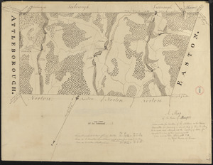
Plan of Attleborough made by Joseph W. Capron, dated March, 1831
663.
Plan of Dighton made by George Walker, Jr., dated March, 1831
664.
Plan of South Hadley made by Daniel Paine, dated March 1831
665.
Plan of Wayland (East Sudbury) made by William C Grout, dated March, 1831
666.
Plan of Otis made by Luke Barber, dated Mar. 10, 1831
667.
Plan of Longmeadow, surveyor's name not given, dated April 1831
668.
Plan of New Marlborough made by Henry Wheeler, dated April 1831
669.
Plan of Tisbury made by Thomas Dunham, dated April 1831
670.
Plan of West Bridgewater, surveyor's name not given, dated 1831
671.
Plan of Chilmark made by Thomas Dunham, dated May 1831
672.
Plan of Easthampton made by Justus Dwight, dated May 1831
673.
Plan of Lenox made by Solomon Cole, dated May 1831
674.
Plan of Southwick made by Amasa Holcomb, dated May, 1831
675.
Plan of Leyden made by H. Newcomb Jr, dated May 3, 1831
676.
Plan of Washington made by Luke Barber, dated May 9, 1831
677.
Plan of Dana made by Ephraim Whipple, dated May 18, 1831
678.
Plan of Worthington made by William Packard, dated May 20, 1831
679.
Plan of Adams made by Thomas A. Brayton, dated June, 1831
680.
Plan of Cummington, surveyor's name not given, dated June 1831
681.
Plan of Dartmouth made by Henry H. Crapo, dated June, 1831
682.
Plan of Russell, surveyor's name not given, dated June 1831
683.
Plan of Savoy made by Levi Leonard, dated June 1831
684.
Plan of Westminster, surveyor's name not given, dated June 1831
685.
Plan of Williamsburg, surveyor's name not given, dated June 1831
686.
Plan of Granville made by Luke Barber, dated June 29, 1831
687.
Plan of Methuen made by Stephen Barker, 2nd, dated July 1831
688.
Plan of Fall River (Troy), surveyor's name not given, dated August 1831
689.
Plan of West Springfield made by J. Lathrop, dated August 1831
690.
Plan of West Springfield made by J. Lathrop, dated August 1831
691.
Plan of Boxborough made by Hoar and Foster, dated September 1, 1831
692.
Plan of Chester made by J. Gould, dated September 1831
693.
Plan of Dorchester and Milton, made by Edmund T. Baker, dated September, 1831
694.
Plan of Goshen made by John Grant, dated September 19, 1831
695.
Plan of Raynham made by Godfrey Robinson, dated September 27, 1831
696.
Plan of Burlington made by Bartholomew Richardson, dated October, 1831
697.
Plan of Lynnfield made by Alonzo Lewis dated October 1831
698.
Plan of Mansfield made by Elijah Hewins dated October 1831
699.
Plan of Southbridge made by Barlow Freeman, dated October, 1831
700.
Plan of Sturbridge made by David Wright, dated October 1831
« Previous
Next »
1
2
…
10
11
12
13
14
15
Limit your search
Place
North and Central America
724
United States
723
Massachusetts
296
Maine
128
Worcester (county)
109
Middlesex (county)
77
Franklin (county)
61
Berkshire (county)
59
more
Place
»
Format
Maps/Atlases
726
Available to use
No known restrictions
726
Date
View distribution
Current results range from
1786
to
1898
Date range begin
Date range end
View larger »
Collection
Town plans, 1794
402
Town plans, 1830
324
Institution
Massachusetts Archives
726