Skip to search
Skip to main content
Digital Commonwealth
Folders
Sign Up / Log In
Search for
Search
Search
Search
Basic
Advanced
Explore
Map
Collections
Institutions
Formats
For Educators
Primary Source Sets
Lesson Plans
Using Primary Sources
Searching Digital Commonwealth
For Institutions
Join Digital Commonwealth
Conferences, Trainings, & Events
How to Contribute Collections
Digitization Services
Board & Committees
Frequently Asked Questions
About
About Digital Commonwealth
News & Announcements
Copyright & Terms of Use
Harmful Content Statement
Partners
API
Contact Us
Lawrence Public Library
Lawrence, Mass. Engineering Department. City Streets
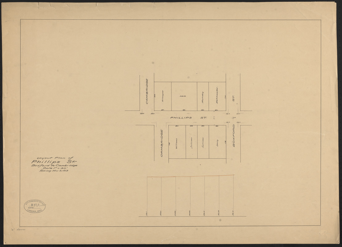
Layout plan of Phillips St., Boxford to Cambridge
Layout plan of Phillips St., Boxford to Cambridge
×
Item Information
Title:
Layout plan of Phillips St., Boxford to Cambridge
Date:
November 3, 1913
Format:
Maps/Atlases
Manuscripts
Genre:
Planning drawings
Location:
Lawrence Public Library
Special Collections
Row 2, Tier E, Shelf 10, Box 3 (shelf locator)
Collection (local):
Lawrence, Mass. Engineering Department. City Streets
Subjects:
Streets
Places:
Massachusetts
>
Essex (county)
>
Lawrence
Extent:
1 map : ms. ; 46 x 67 cm
Permalink:
https://ark.digitalcommonwealth.org/ark:/50959/nk323843c
Terms of Use:
No known copyright restrictions.
No known restrictions on use.
Scale:
Scale 1:480
Language:
English
Notes:
Title from item.
Notes (date):
Date from item.
Accession #:
2009.9.2.13
Identifier:
27
3473
Barcode:
31549004504006
show more...
View MODS XML
More Like This
Abbott St.
Acceptance plan, Jasper St. from Floral to Cypress and Linden to ...
Acceptance plan, King St., Kendall to Boston
Acceptance plan of South Bowdoin Street in Lawrence, Mass.
Find More Like This >>
Tools
Share
Facebook
Pinterest
X
Reddit
Tumblr
Email
Copy link
Add to Folder
Questions/Comments
Cite This Item
Downloads
Primary (full resolution, uncompressed)
(TIF, 113 MB)
Large (full resolution)
(JPEG, 9.46 MB)
Medium
(JPEG, 149 KB)