Skip to search
Skip to main content
Digital Commonwealth
Sign Up / Log In
Search for
Search
Search
Search
Basic
Advanced
Explore
Map
Collections
Institutions
Formats
For Educators
Primary Source Sets
Lesson Plans
Using Primary Sources
Searching Digital Commonwealth
For Institutions
Join Digital Commonwealth
Conferences, Trainings, & Events
How to Contribute Collections
Digitization Services
Board & Committees
Frequently Asked Questions
About
About Digital Commonwealth
News & Announcements
Copyright & Terms of Use
Harmful Content Statement
Partners
API
Contact Us
Town of Rockport
Rockport Town Clerk, Street, Roads and Maps
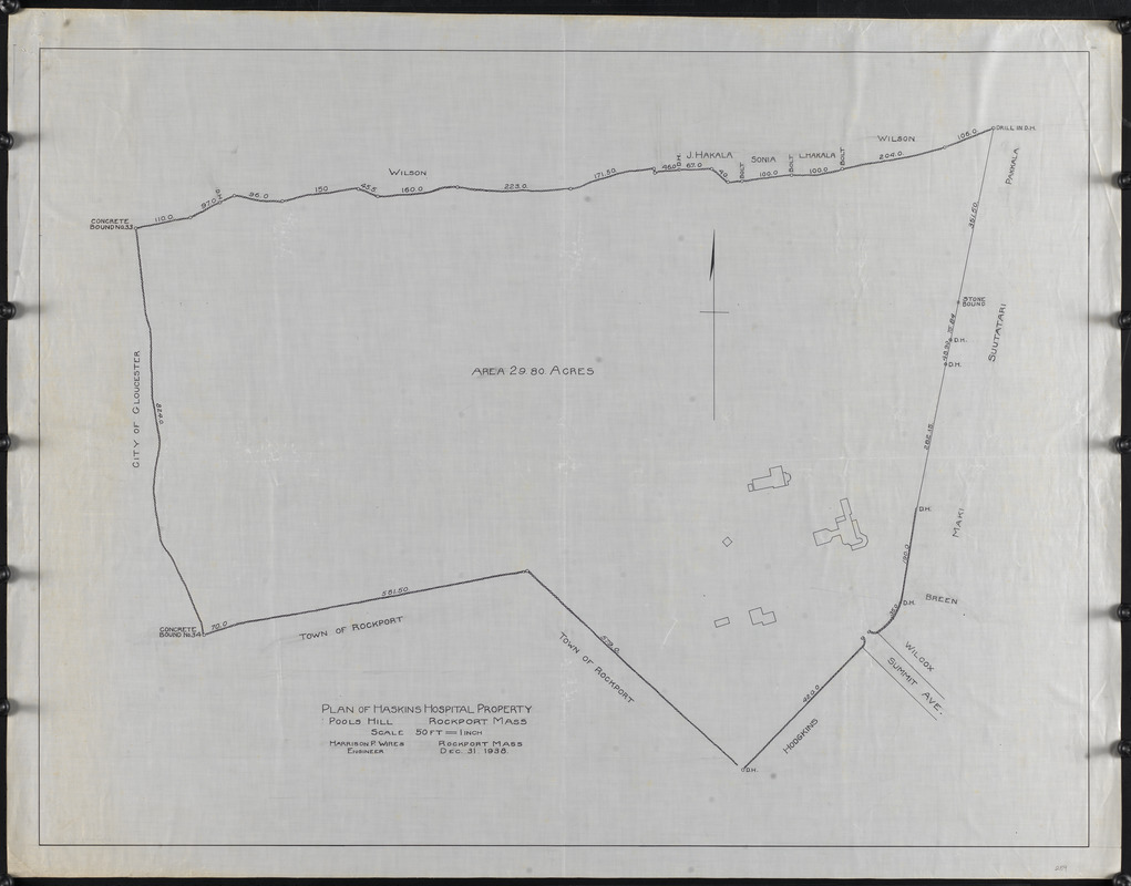
Plan of Haskins Hospital property, Pools Hill, Rockport, Mass.
Plan of Haskins Hospital property, Pools Hill, Rockport, Mass.
×
Item Information
Title:
Plan of Haskins Hospital property, Pools Hill, Rockport, Mass.
Name on Item:
Harrison P. Wires, engineer
Date:
December 31, 1938
Format:
Maps/Atlases
Manuscripts
Genre:
Planning drawings
Manuscript maps
Location:
Town of Rockport
Collection (local):
Streets, Roads and Maps of Rockport, MA 1823-1974 (approximate)
Places:
Massachusetts
>
Essex (county)
>
Pool Hill
(peak)
Extent:
1 map : ms. ; 81 x 106 cm
Permalink:
https://ark.digitalcommonwealth.org/ark:/50959/dz011066r
Terms of Use:
Rights status not evaluated.
No known restrictions on use.
Scale:
Scale 1:600
Language:
English
Notes:
Title from item.
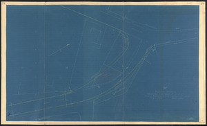
This map is the source of the blueprint in 112.
Notes (date):
Date from item.
Identifier:
259
PF-4-10
show more...
View MODS XML
More Like This
"A" sketch showing proposed changes of line at Beach & Granite ...
Bearskin Neck lots
Cape Ann Tool Company
Cogswell Farm Landing
Find More Like This >>
Tools
Share
Facebook
Pinterest
X
Reddit
Tumblr
Email
Copy link
Add to Folder
Questions/Comments
Cite This Item
Downloads
Primary (full resolution, uncompressed)
(TIF, 192 MB)
Large (full resolution)
(JPEG, 16.1 MB)
Medium
(JPEG, 159 KB)