Sudbury Valley Trustees : property maps 1984
Item Information
- Title:
- Sudbury Valley Trustees : property maps 1984
- Description:
-
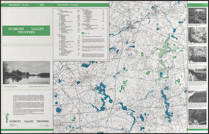
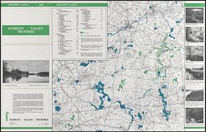
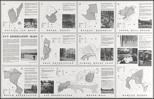
Sudbury Valley Trustees is a charitable corporation protecting the natural resources of the Sudbury River Valley since 1953. The maps show the Sudbury Valley Trustees' properties that are most suitable for walking or cross-country skiing. It provides the location, it relatives size and its most used trails. The sources for the map come from town atlases, assessors sheets, the United States Geodetic Survey quadrangle maps, aerial photographs, and people familiar with the area. Horseback riding are allowed on the indicated bridle trails. Individual maps also provide specific description for that particular area/walks. Photographs of each area are shown. Individual locations highlighted are: Wayside Inn Road, Framingham -- Brues Woods, Sudbury -- Walkup Memorial, Westborough -- Upper Mill Brook, Wayland -- Gray Reservation, Sudbury -- School House Pond, Wayland -- Welch Reservation, Framingham -- Fay Reservation/Round Hill, Sudbury -- Hamlen Woods, Wayland. On the reverse side, a large map covers portions of the towns of Westborough, Southborough, Marlborough, Ashland, Framingham, Sudbury, Maynard, Stow, Acton, Concord, Lincoln, Wayland, and Natick. It also includes an index of properties owned Concord, Sudbury, Wayland, Framingham, and Westborough. Great Meadow National Wildlife Refuge properties are also highlighted.
- Name on Item:
-
designed by Mary Eugenia Myer
- Date:
-
1984
- Format:
-
Maps/Atlases
- Genre:
-
Reservation maps
- Location:
-
Wayland Free Public Library
Conservation Land 1980-1999 (shelf locator) - Collection (local):
-
Wayland Historical Maps and Plans
- Series:
- 1900 Maps Conservation Maps
- Subjects:
-
Ballou, Frederick
Holmes, Penny
King, Fred
Moon, Kenneth
Moore, Otis
Morgan, Allen
Newbury, Sally
- Places:
-
MassachusettsMiddlesex (county)Framingham
MassachusettsMiddlesex (county)Sudbury
MassachusettsMiddlesex (county)Wayland
MassachusettsWorcester (county)Westborough
Round Hill
Brues Woods
Gray Reservation
Hamlen Woods
School House Pond
Upper Mill Brook
Walkup Memorial
Wayside Inn Road (Framingham, Mass.)
Welch Reservation (Framingham, Mass.)
- Extent:
- 10 maps on 1 sheet : color, both sides ; each 58 x 59 cm or smaller, on sheet 58 x 91 cm
- Permalink:
- https://ark.digitalcommonwealth.org/ark:/50959/0c486577z
- Terms of Use:
-
Rights status not evaluated.
This work is licensed for use under a Creative Commons Attribution Non-Commercial No Derivatives License (CC BY-NC-ND).