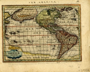
Detailed map of the Americas, which appeared in Jansson's Atlas Minor. Features a large land mass between North America and Asia. This configuration was derived from the globe of Plancius and Van Den Keere of 1614, which was also engraved by Abraham Goos, the engraver of this map. The coastline may be in response to the reported discoveries of Juan de Fuca along the NW Coast of America. This map is noteworthy as the first depiction of this elongated coastline on a printed map. Also noteworthy is the depiction of the St. Lawrence River, which is shown extending to what would be modern-day Colorado. "Von Amerika" at top of map. German text on verso.