Skip to search
Skip to main content
Digital Commonwealth
Sign Up / Log In
Search for
Search
Search
Search
Basic
Advanced
Explore
Map
Collections
Institutions
Formats
For Educators
Primary Source Sets
Lesson Plans
Using Primary Sources
Searching Digital Commonwealth
For Institutions
Join Digital Commonwealth
Conferences, Trainings, & Events
How to Contribute Collections
Digitization Services
Board & Committees
Frequently Asked Questions
About
About Digital Commonwealth
News & Announcements
Copyright & Terms of Use
Harmful Content Statement
Partners
API
Contact Us
State Library of Massachusetts
Other
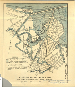
Relation of the Fens Basin to the former Tide Mill ponds
View this item online at State Library of Massachusetts
Item Information
Title:
Relation of the Fens Basin to the former Tide Mill ponds
Format:
Maps/Atlases
Location:
State Library of Massachusetts
Collection (local):
Other
Series:
Maps
Subjects:
Back Bay (Boston, Mass.)--Maps
Fenway (Boston, Mass.)--Maps
Places:
Massachusetts
>
Suffolk (county)
>
Boston
Link to Item:
http://archives.lib.state.ma.us/handle/2452/50193
Terms of Use:
Rights status not evaluated.
Contact host institution for more information.
Notes:
Publication date unknown.
Identifier:
ocm30691579
show more...
View MODS XML
More Like This
Area plan as of May 1962
Atlas of the county of Suffolk, Massachusetts : vol. 2nd late city ...
Back Bay park
Proposed improvement of Back Bay
Find More Like This >>
Tools
Share
Facebook
Pinterest
X
Reddit
Tumblr
Email
Copy link
Add to Folder
Questions/Comments
Cite This Item
We'd love your feedback!
×
Would you be interested in taking a short survey about Digital Commonwealth?