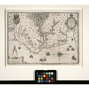
Nova Anglia
Item Information
- Title:
- Nova Anglia
- Description:
-
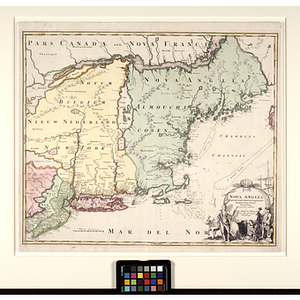
This finely colored and engraved map delineates the northeast coast of the present-day United States, done in a period when claim over the vast territory was still very much a source of conflict between Holland and England. Homann, a German cartographer, ascribed much of present-day New England and part of Canada to Britain, calling the region "Nova Anglia," while most of New York he gave to Holland, calling it "Novum Belgium" or "Nieuw Nederland." The confusion of the competing national claims is evident in the very mixture of languages that appear on this map, including English, Dutch, Latin, and French, and this map is, overall, a fascinating glimpse into the colonial history of the American northeast. In addition to its historical interest, it is an important monument in the evolving geographical knowledge of the area, as well as an example of the highest quality in cartography from the early eighteenth century. Vivid original color highlights the central areas depicted, while a cartouche at lower-right testifies to Homann's abilities as a draftsman, with the text flanked by a Native American (rather westernized in appearance, but in fancifully exotic attire) and a colonist holding a pelt (the fur trade, of course, being one of the main reasons for European interest in the region). Born in Kammlach in 1663, Homann was the founder of a family firm that became a virtual cartographic dynasty, dominating the German and international map market for a century. Homann founded his firm in 1702, and produced his first atlas in 1704. His legacy extended beyond his years, however, as his atlases continued to be published for thirty years following his death, and his descendants, under the name "Homann Heirs," continued to produce maps and atlases long after that. Along with Matthias Seutter, Homann was largely responsible for the German resurgence in the field of cartography, which had so long been dominated by Dutch firms centered in Amsterdam. Homann made his way not merely as an engraver and mapseller, but also served as the geographer to the Kaiser of the Holy Roman Empire beginning in 1715. He received commissions as an engraver from David Funck, and also lent his skill to such notables as Jacob von Sandrart and Heinrich Scherer for their publications. For his strides in cartography, Homann was eventually honored with membership in the Prussian Royal Academy of Science. This is an important map by one of the most significant eighteenth-century German mapmakers.
- Cartographer:
- Homan, Johann Baptist, 1663-1724
- Date:
-
[ca. 1716]
- Format:
-
Documents
Maps/Atlases
- Genre:
-
maps (documents)
historical maps
- Location:
- Northeastern University Library
- Collection (local):
-
Early American and European Maps
- Subjects:
-
Early American Maps
- Places:
-
Canada
New England
New Netherland
New York (State)
New Jersey
Canada
Massachusetts
Boston (Mass.)
Connecticut
Champlain, Lake
- Link to Item:
- http://hdl.handle.net/2047/d20129088
- Terms of Use:
-
No Copyright. The organization that has made the Item available believes that the Item is in the Public Domain under the laws of the United States, but a determination was not made as to its copyright status under the copyright laws of other countries. The Item may not be in the Public Domain under the laws of other countries. Please refer to the organization that has made the Item available for more information. http://rightsstatements.org/vocab/NoC-US/1.0/
Contact host institution for more information.
- Place of origin:
-
Nuremberg
- Notes:
-
The Abstract/Description provided for this map is taken from an accompanying gallery schedule.
- Identifier:
-
american_homann_001