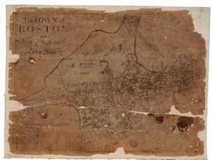
The Town of Boston in New England by Capt. John Bonner
Description:
The Town of Boston in New England by John Bonner is the first printed map of Boston, Massachusetts. Bonner (circa 1643-1726) was a captain, navigator, and shipwright. His map includes street layouts, churches, and public buildings. The map also illustrates Boston's importance as a port city, detailing the location of docks, shipyards, wharves, and ropewalks. Bonner's map includes the years of construction for significant churches and public buildings, as well as the years in which there occurred great fires and outbreaks of smallpox. At the time of printing, Boston had 42 streets, 36 lanes, and 22 alleys. There were nearly 3,000 houses of which 1,000 were brick and the rest were of timber. The population was estimated to be near 15,000. Boston: printed by Francis Dewing, 1722 [i.e. 1725] This map is imperfect. Only known impression of the third state of the 1722 Bonner map, likely published in 1725.
Item from the collections of the Massachusetts Historical Society. Image use and licensing information: www.masshist.org/library/permissions
Contact host institution for more information.