Skip to search
Skip to main content
Skip to first result
Digital Commonwealth
Folders
Sign Up / Log In
Search for
Search
Search
Search
Basic
Advanced
Explore
Map
Collections
Institutions
Formats
For Educators
Primary Source Sets
Lesson Plans
Using Primary Sources
Searching Digital Commonwealth
For Institutions
Join Digital Commonwealth
Conferences, Trainings, & Events
How to Contribute Collections
Digitization Services
Board & Committees
Frequently Asked Questions
About
About Digital Commonwealth
News & Announcements
Copyright & Terms of Use
Harmful Content Statement
Partners
API
Contact Us
Search
Search Constraints
Start Over
Save Search
Your search:
More Like
commonwealth:7h14b143n
✖
Remove constraint More Like: commonwealth:7h14b143n
« Prev.
|
11,121
-
11,140
of
11,530
|
Next »
Sort
by relevance
relevance
title
date (asc)
date (desc)
Number of results to display per page
20
per page
per page
10
per page
20
per page
50
per page
100
per page
View results as:
List
list view
Maps
map view
Gallery
grid view
Search Results
11121.
View of Bethel, Conn
11122.
View of Beverly, Mass
11123.
A view of Boston
11124.
View of Boston freight terminals, the New York, New Haven & Hartford Railroad
11125.
View of Boston, July 4th 1870
11126.
A view of Boston taken on the road to Dorchester
11127.
View of Bristol, Conn
11128.
View of Canton, Mass : 1878
11129.
View of Cape Egmont and winter Rock from the eastward : Entrance of Egmont Harbor ; The entrance of Keppel Harbor, 10 leagues...
11130.
View of Chatham : New Brunswick
11131.
View of Cheshire, Connecticut : 1882
11132.
View of Chester, Connecticut : 1881
11133.
View of Clinton, Connecticut : 1881
11134.
View of College Point, L.I : 1876
11135.
View of Collinsville, Conn : 1878
11136.
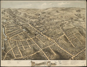
View of Danbury, Conn : 1875
11137.
View of Dedham, Mass. in 1876
11138.
View of East Boston, Mass : 1879
11139.
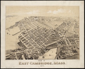
View of East Cambridge, Mass., 1879
11140.
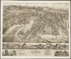
View of Essex, Centerbrook & Ivoryton, Conn : 1881
« Previous
Next »
1
2
…
553
554
555
556
557
558
559
560
561
…
576
577
Limit your search
Subject
Real property--Massachusetts--Boston--Maps
2,278
Landowners--Massachusetts--Boston--Maps
2,117
Boston (Mass.)--Maps
1,979
Roxbury (Boston, Mass.)--Maps
351
Dorchester (Boston, Mass.)--Maps
317
Massachusetts--Maps
271
Cambridge (Mass.)--Maps
266
Brookline (Mass.)--Maps
236
more
Subject
»
Place
North and Central America
8,812
United States
7,717
Massachusetts
5,067
Suffolk (county)
3,357
Boston
3,217
Europe
1,359
Middlesex (county)
618
Canada
453
more
Place
»
Format
Maps/Atlases
11,470
Manuscripts
217
Prints
56
Books
36
Objects/Artifacts
10
Drawings/Illustrations
8
Posters
4
Available to use
No known restrictions
11,352
Creative Commons license
51
Date
View distribution
Current results range from
1482
to
2023
Date range begin
Date range end
View larger »
Unknown
2
Collection
Norman B. Leventhal Map & Education Center Collection
11,420
Boston and New England Maps (Collection of Distinction)
5,162
Urban Maps (Collection of Distinction)
4,858
Maritime Charts and Atlases (Collection of Distinction)
1,081
American Revolutionary War-Era Maps (Collection of Distinction)
637
Boston Redevelopment Authority Collection
90
Historic Maps
39
David Judkins Weaver Papers
22
more
Collection
»
Institution
Boston Public Library
11,420
Salem State University Archives and Special Collections
39
State Library of Massachusetts
33
American Antiquarian Society
18
Phillips Academy
11
Private Collection
3
Jones Library, Amherst
2
Massachusetts Historical Society
2
more
Institution
»