Massachusetts Archives
Land study maps, 1936-1937
Detail from:
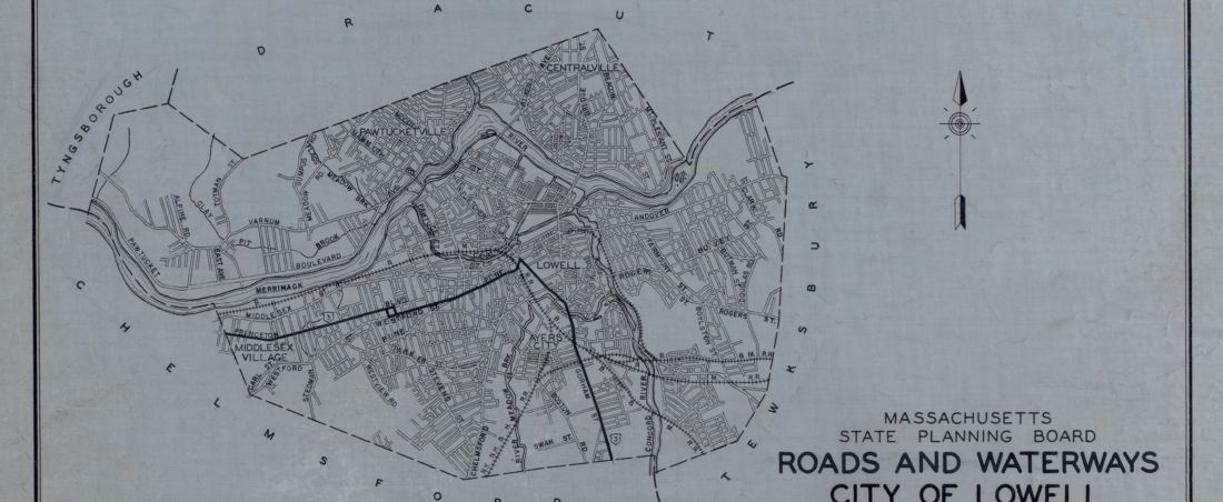
Roads and Waterways City of Lowell
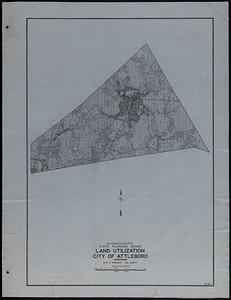
The State Planning Board, established in Massachusetts per St 1935, c 475, s 2, was responsible for preparing and updating a master plan for the physical development of the Commonwealth. The plan served as the basis for projects focused on forestry, agriculture, and industrial, recreational, and residential planning. The plan was used to guide conservation, land settlement, waste reduction, health and safety, urban and rural development, land use allocation, and the creation of state forests and parks. Land study maps were created as part of the master plan. The maps were produced from 1936 to 1943 by the Works Progress (from 1939 Work Projects) Administration, under the sponsorship of the State Planning Board, with field data obtained by municipalities. They indicate important landmarks such as state highways, bridges, waterways, parks, reservations, forests, airports, drainage and sanitary systems, railroads, power transmission facilities, public buildings, and public spaces.
Each municipality has a set of five maps: topography, roads and buildings, land utilization, soil classification, and roads and waterways. The topography map shows the topography with contours of 20-foot intervals. The roads and buildings map shows the location of roads, bridges, and buildings, differentiating among farm, residential, commercial, and industrial buildings, and other developments, such as schools, hospitals, churches, parks, airports, cemeteries, and reservoirs. The land utilization map shows existing land use, indicating areas devoted to forests, as well as agricultural, recreational, industrial, commercial, and residential uses. The soil classification map shows the moisture and texture of the soil, classified in several groups based on productivity and adaptability for agriculture, forestry, and others. The roads and waterways map shows roads and waterways, with street names and essential information for transportation and water supply. Series includes a legend explaining map symbols used for designations such as geographic boundaries, topographical counters, cropland, pastures, forests, swamps, parks, public areas, thickly settled areas, industrial and commercial areas, private estates, residential buildings, farms, public buildings, roads, U.S. routes, railroads, canals, tunnels, and six groups of soil classifications from droughty to wet soils. Some localities lack complete sets. Maps for Amherst, Andover, Ashburnham, Belchertown, Blandford, Bourne are lacking. Dukes, Nantucket, and Suffolk counties were not surveyed. Also known as: Work Projects Administration maps; Works Progress Administration maps; WPA maps.
Each municipality has a set of five maps: topography, roads and buildings, land utilization, soil classification, and roads and waterways. The topography map shows the topography with contours of 20-foot intervals. The roads and buildings map shows the location of roads, bridges, and buildings, differentiating among farm, residential, commercial, and industrial buildings, and other developments, such as schools, hospitals, churches, parks, airports, cemeteries, and reservoirs. The land utilization map shows existing land use, indicating areas devoted to forests, as well as agricultural, recreational, industrial, commercial, and residential uses. The soil classification map shows the moisture and texture of the soil, classified in several groups based on productivity and adaptability for agriculture, forestry, and others. The roads and waterways map shows roads and waterways, with street names and essential information for transportation and water supply. Series includes a legend explaining map symbols used for designations such as geographic boundaries, topographical counters, cropland, pastures, forests, swamps, parks, public areas, thickly settled areas, industrial and commercial areas, private estates, residential buildings, farms, public buildings, roads, U.S. routes, railroads, canals, tunnels, and six groups of soil classifications from droughty to wet soils. Some localities lack complete sets. Maps for Amherst, Andover, Ashburnham, Belchertown, Blandford, Bourne are lacking. Dukes, Nantucket, and Suffolk counties were not surveyed. Also known as: Work Projects Administration maps; Works Progress Administration maps; WPA maps.