Wayland Town Clerk
Wayland Massachusetts Historical Town Records (AKA Sudbury, Massachusetts (1638-1780), East Sudbury, Massachusetts (1780-1835), & Cochituate Massachusetts (1848 to date))
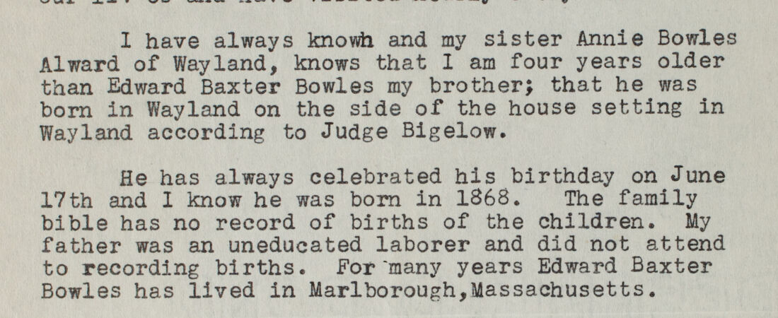
Detail from:
Wayland births, 1868-1925 (individual certificates)
In 1638, when only Native American trails crossed the land, Mr. Pendleton, Mr. Noyes, and Mr. Brown petitioned the General Court for the New Plantation by Concord, just four miles south by the river. From an artifact found along the river, we know that Native Americans have been in this area for more than 6,000 years. The English men did pay for the land, but the Native Americans may not have understood the rights they were giving up. The natives and the newcomers lived peacefully near each other until King Philip’s War.
The northern part of the current Town of Wayland was originally known as the Sudbury Plantation. The southern portion of the town was a collection of farms -- known as Natick Farmers -- including Henry Dunster, first president of Harvard, widow Elizabeth Glover, who brought the first printing press to Massachusetts Bay Colony, and William Jennison, a Watertown captain who served in the Pequot War. These farms were added to the town on June 9, 1721. The United States Census Bureau says the current town, based on data from 2000, is a total area of 15.9 square miles of which 15.2 square miles is land and 0.7 square miles, or 4.21 percent, is water.
1640 saw the first official religious meeting and, in 1643, a Meeting House was built. It served for town government and religious gatherings in what is now North Cemetery of Wayland. As it is today, the town was governed by town meetings and selectmen. The oldest house standing in town, built circa 1690, at one time belonged to Dorothy Noyes and her husband, Rev. Samuel Parris, a major figure in the Salem witch trials and later a school master in Wayland. They lived there between 1712 and 1720. On April 19, 1775, 302 men and boys, the largest representation from any one town, responded to the Lexington-Concord alarm. Col. Henry Knox brought the Ticonderoga cannons through what is the current Wayland to Dorchester Heights.
The natural barrier of the river made traveling to the Meeting House difficult for the extended Sudbury Plantation community on the west side. Efforts were made to separate from the town and, after several attempts, the final separation occurred in 1780. Since the original Sudbury Plantation wanted the division, the name and town records remained with the extended land to the west by the ruling of the General Court as required by law. The new name for the east side of the town was East Sudbury.
East Sudbury changed the town’s name in 1835 to Wayland, chosen to honor Francis Wayland, doctor, professor, theologian, economist, reformist, library supporter, and Brown University president. The Wayland Library was founded in 1848 as arguably the first free public library in Massachusetts. Rev. John Wight, a Wayland Representative in the General Court, introduced a bill that resulted in the Library Act of 1851, making it legal to raise and spend public funds to “establish and maintain libraries for the use of the inhabitants thereof.” In 1881, the Massachusetts Central Railroad came through Wayland and lasted for 90 years, ending in 1971. Today it is the rail trail for the community.
Through the years, as Sudbury, East Sudbury, and then Wayland, the community was mostly agricultural. Individual home industry, such as shoe making, did exist and the first shoe factory was built in 1830 in the southern portion of the town. This brought in an influx of immigrants and an increase in the population and thus a larger demand for housing and transportation. By the late 1800s, most of the major town offices were filled by south side residents. With population and wealth shifting to the growing south side of town, political power shifted to that side as well. Major changes were made to the infrastructure -- at least on the south side -- such as the construction of a water system, electric street lighting, and the addition of schools to serve this growing population.
The power in south Wayland had the effect of increasing the tax burden on north Wayland as well. Still mostly agrarian, the north side of town did not benefit from the industrial base as much as those in the newly urbanized area. This led to frictions, which culminated in a petition for separation in 1881. While this petition failed to garner the needed votes, it stimulated town officials to favor north Wayland more than before by holding more public meetings in Wayland Center. There were subsequent, weaker attempts to split into two towns, or to join the southern portion of the town to neighboring Natick. In the 1890s, there was some talk in Natick about annexing part of Wayland, so that Natick might then become a city. Although attempts at separation finally waned, the political situation remained tense for several years as more and larger municipal projects, such as schools and town halls, were considered. However, as technology and advances in transportation made the shoe industry uneconomical, it passed away from the Wayland community scene.
Wayland’s southern end bordered Long Pond, which was important to Boston’s water supply. At the opening of the aqueduct in 1848, the Mayor of Boston, Josiah Quincy IV, thought an Indian name would be more appealing to Bostonians, so it and the lake’s name was changed to Cochituate, meaning head of running water. The lasting effect was that the southern part of Wayland became known as Cochituate, where the aqueduct pumping house was located. The populous village, after leaving the industrial age, became a summer retreat and a bedroom community. Cochituate Village would be demarcated in U.S. Census, vital records, military records, town reports, and other official records. While officially part of Wayland, Cochituate seems to have a history of its own.
Three public cemeteries are located in Wayland and Cochituate Village. They are North Cemetery (1643), South (or Center) Cemetery (1835) and Lakeview Cemetery (circa 1821 and formally accepted est. 1871). North Cemetery is the final resting place for many families from the current Sudbury town. There are also private cemeteries: St. Zepherin’s Cemetery (circa 1890) and the Jewish Cemetery Association of Massachusetts (Beit Olam Cemetery [1999] and Beit Olam East Cemetery [2010]). Two cemeteries that are no longer in existence are the Draper Cemetery (at Tower Hill for Draper family only) and Episcopal Church of the Holy Spirit Cemetery (on Rice Road, closed in 2015 after 50 years and some graves may have been moved).
The people who resided, made decisions, and used skills and character qualities to work in politics for Wayland can be found in the public records. Town records, vital records, military lists, etc., all tell part of the history of Wayland and Cochituate village. Researchers and genealogists will find these papers important for identifying individuals, but further extensive investigation into the Wayland collections is needed to determine the activities and attributes that define a Wayland/Cochituate citizen.