Skip to search
Skip to main content
Skip to first result
Digital Commonwealth
Folders
Sign Up / Log In
Search for
Search
Search
Search
Basic
Advanced
Explore
Map
Collections
Institutions
Formats
For Educators
Primary Source Sets
Lesson Plans
Using Primary Sources
Searching Digital Commonwealth
For Institutions
Join Digital Commonwealth
Conferences, Trainings, & Events
How to Contribute Collections
Digitization Services
Board & Committees
Frequently Asked Questions
About
About Digital Commonwealth
News & Announcements
Copyright & Terms of Use
Harmful Content Statement
Partners
API
Contact Us
Search
Search Constraints
Start Over
Save Search
Your search:
More Like
commonwealth-oai:ww72bf933
✖
Remove constraint More Like: commonwealth-oai:ww72bf933
« Prev. |
1
-
10
of
433
|
Next »
Sort
by relevance
relevance
title
date (asc)
date (desc)
Number of results to display per page
10
per page
per page
10
per page
20
per page
50
per page
100
per page
View results as:
List
list view
Maps
map view
Gallery
grid view
Search Results
1.
Area plan as of May 1962
2.
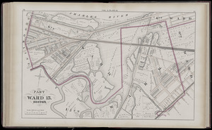
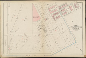
Atlas of the county of Suffolk, Massachusetts : vol. 2nd late city of Roxbury, now wards 13-14 and 15, city of Boston : plate R
3.
Back Bay park
4.
Proposed improvement of Back Bay
5.
Study of plan for the extension of Commonwealth Avenue on the line of Beacon Street
6.
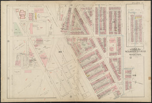
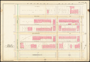
Atlas of the city of Boston : city proper : plate P
7.
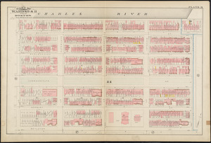
Atlas of the city of Boston : city proper : plate R
8.
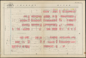
Atlas of the city of Boston : city proper : plate S
9.
Atlas of the city of Boston : city proper : plate T
10.
Atlas of the city of Boston : city proper : plate 39
« Previous
Next »
1
2
3
4
5
…
43
44
Limit your search
Subject
Real property--Massachusetts--Boston--Maps
195
Landowners--Massachusetts--Boston--Maps
192
Fenway (Boston, Mass.)--Maps
164
Boston (Mass.)--Maps
139
Back Bay (Boston, Mass.)--Maps
129
Hoosac Tunnel (Mass.)--Photographs
112
Tunnels--Massachusetts--Photographs
67
City planning--Massachusetts--Boston--Maps
62
more
Subject
»
Place
North and Central America
433
United States
433
Massachusetts
343
Boston
289
Suffolk (county)
289
Back Bay
118
Fens
79
Roxbury
36
more
Place
»
Format
Maps/Atlases
321
Photographs
112
Drawings/Illustrations
1
Available to use
No known restrictions
284
Creative Commons license
1
Date
View distribution
Current results range from
1800
to
2017
Date range begin
Date range end
View larger »
Collection
Boston and New England Maps (Collection of Distinction)
283
Urban Maps (Collection of Distinction)
281
Norman B. Leventhal Map Center Collection
229
Other
145
Boston Redevelopment Authority Collection
68
Massachusetts Board of Harbor and Land Commissioners
3
Institution
Boston Public Library
285
State Library of Massachusetts
148