Skip to search
Skip to main content
Skip to first result
Digital Commonwealth
Folders
Sign Up / Log In
Search for
Search
Search
Search
Basic
Advanced
Explore
Map
Collections
Institutions
Formats
For Educators
Primary Source Sets
Lesson Plans
Using Primary Sources
Searching Digital Commonwealth
For Institutions
Join Digital Commonwealth
Conferences, Trainings, & Events
How to Contribute Collections
Digitization Services
Board & Committees
Frequently Asked Questions
About
About Digital Commonwealth
News & Announcements
Copyright & Terms of Use
Harmful Content Statement
Partners
API
Contact Us
Search
Search Constraints
Start Over
Save Search
Your search:
More Like
commonwealth:z603vg239
✖
Remove constraint More Like: commonwealth:z603vg239
« Prev. |
1
-
20
of
175
|
Next »
Sort
by relevance
relevance
title
date (asc)
date (desc)
Number of results to display per page
20
per page
per page
10
per page
20
per page
50
per page
100
per page
View results as:
List
list view
Maps
map view
Gallery
grid view
Search Results
1.
Carte de la Caroline et Georgie. : Pour servir à l'Histoire générale des voyages
2.
A new & accurate map of the provinces of North & South Carolina Georgia &c
3.
A New and accurate map of the chief parts of South Carolina, and Georgia
4.
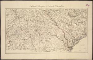
Middle Georgia & South Carolina
5.
[Middle Georgia and South Carolina]
6.
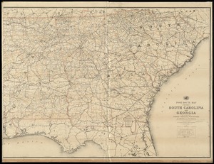
Post route map of the States of South Carolina and Georgia with adjacent parts of North Carolina, Tennessee, Alabama and...
7.
J.H. Colton's topographical map of North and South Carolina : a large portion of Georgia & part of adjoining states
8.
North Carolina & South Carolina
9.
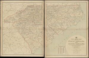
Post route map of the states of North Carolina and South Carolina showing post offices with the intermediate distances and mail...
10.
Post route map of the states of North Carolina and South Carolina showing post offices with the intermediate distances and mail...
11.
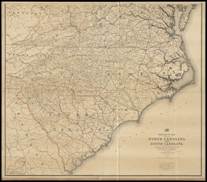
Post route map of the states of North Carolina and South Carolina with adjacent parts of Georgia, Tennessee, Kentucky, West...
12.
The State of South Carolina: : from the best authorities. 1796
13.
Georgia from the latest authorities
14.
A New map of the Cherokee nation : with the names of the towns & rivers they are situated on No. lat from 34 to 36
15.
North Carolina form the best authorities. 1800
16.
The state of North Carolina from the best authorities
17.
The Rand McNally new commercial atlas map of South Carolina
18.
South Carolina
19.
The state of South Carolina : from the best authorities
20.
Georgia, from the latest authorities
« Previous
Next »
1
2
3
4
5
…
8
9
Limit your search
Subject
North Carolina--Maps
25
United States--Maps
20
Georgia--Maps
18
North America--Maps
17
West Indies--Maps
17
South Carolina--Maps
15
Canada--Maps
14
Boston (Mass.)--Maps
9
more
Subject
»
Place
North and Central America
137
United States
52
Canada
22
North Carolina
22
Georgia
18
North America
17
West Indies
17
South Carolina
15
more
Place
»
Format
Maps/Atlases
175
Manuscripts
12
Available to use
No known restrictions
37
Creative Commons license
1
Date
View distribution
Current results range from
1750
to
1919
Date range begin
Date range end
View larger »
Collection
American Revolutionary War-Era Maps (Collection of Distinction)
139
American Antiquarian Society Collection
138
Norman B. Leventhal Map Center Collection
37
Boston and New England Maps (Collection of Distinction)
1
Maritime Charts and Atlases (Collection of Distinction)
1
Institution
American Antiquarian Society
138
Boston Public Library
37


![[Middle Georgia and South Carolina]](https://bpldcassets.blob.core.windows.net/derivatives/images/commonwealth:7h14b2665/image_thumbnail_300.jpg)