Skip to search
Skip to main content
Skip to first result
Digital Commonwealth
Folders
Sign Up / Log In
Search for
Search
Search
Search
Basic
Advanced
Explore
Map
Collections
Institutions
Formats
For Educators
Primary Source Sets
Lesson Plans
Using Primary Sources
Searching Digital Commonwealth
For Institutions
Join Digital Commonwealth
Conferences, Trainings, & Events
How to Contribute Collections
Digitization Services
Board & Committees
Frequently Asked Questions
About
About Digital Commonwealth
News & Announcements
Copyright & Terms of Use
Harmful Content Statement
Partners
API
Contact Us
Search
Search Constraints
Start Over
Save Search
Your search:
More Like
commonwealth:x633fb29b
✖
Remove constraint More Like: commonwealth:x633fb29b
« Prev. |
1
-
100
of
207
|
Next »
Sort
by relevance
relevance
title
date (asc)
date (desc)
Number of results to display per page
100
per page
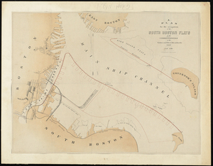
per page
10
per page
20
per page
50
per page
100
per page
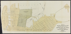
View results as:
List
list view
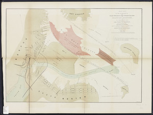
Maps
map view
Gallery
grid view
Search Results
1.
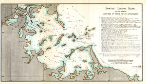
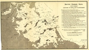
Boston Harbor, Mass.: Sketch Showing Locations of Works For Its Improvement.
2.
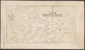
Boston Harbor, Massachusetts
3.
Eldridge's new chart of Boston Harbor : compiled from the latest surveys
4.
New chart of Boston Harbor
5.
Carte de la Baye de Baston : située dans la Nouvelle Angleterre
6.
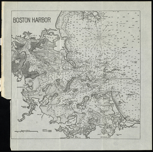
Boston Harbor, Massachusetts
7.
Boston Harbor, Massachusetts
8.
Boston Harbour : from the survey of A.S. Wadsworth, Esq., U.S.N. and the chart of Des Barres
9.
A chart of the Harbour of Boston, with the soundings, sailing-marks and other directions
10.
Plan of the Inner Harbor of Boston
11.
Boston Harbor
12.
Boston Harbor, Massachusetts
13.
Plano de la bahia y puerto de Boston
14.
Sketch of Boston Harbor and Bay
15.
Boston Harbor, Massachusetts
16.
Boston Harbour : from the survey of A.S. Wadsworth Esq. U.S.N. and the chart of Des Barres
17.
Boston Harbour: From the Survey of A.S. Wadsworth Esq., U.S.N, and the Survey of Des Barres.
18.
Boston Harbour: From the Survey of A.S. Wadsworth Esq., U.S.N, and the Survey of Des Barres.
19.
Chart of Boston Harbour : surveyed in 1817
20.
Map of Boston inner harbor to accompany report under chapter 93, resolves of 1907, December 1, 1907
21.
Boston Bay and approaches
22.
Boston Harbour
23.
Map of parts of Boston Harbor and its tributaries
24.
Map to accompany report of State Board on Docks and Terminal Facilities : showing existing conditions and proposed changes at...
25.
A new survey of the harbour of Boston in New England : done by order of the principall officers and comissioners of Her Maties....
26.
Plan of Boston
27.
Plan of Boston
28.
Boston Bay
29.
Massachusetts Bay with the coast from Cape Ann to Cape Cod
30.
Boston Bay and Harbor
31.
Boston Harbor
32.
Boston Harbor
33.
Boston Harbor
34.
Boston Harbor & vicinity
35.
Boston Harbor Mass : Charles River from Brookline Street bridge to Market Street bridge
36.
Boston Harbor, Mass : map of Charles River from Brookline Street bridge to its mouth
37.
Boston Harbor, Mass.: Sketch Showing Locations of Works For Its Improvement.
38.
Boston Harbor, Massachusetts
39.
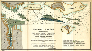
Boston Harbor, Massachusetts: The Main Ship Channel Above Lower Middle
40.
Boston Inner Harbor Massachusetts
41.
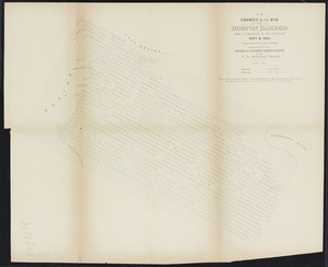
Changes in the bed of Boston Harbor from a comparison of the surveys of 1835-61
42.
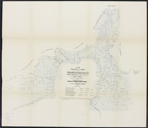
Changes in the bed of Boston harbor. Sheet 1: From a comparison of the surveys of 1835 & 1847
43.
Changes in the bed of Boston harbor. Sheet 2: From a comparison of the surveys of 1847 & 1861
44.
Changes in the bed of Boston harbor. Sheet 3: From a comparison of the surveys of 1835 & 1861
45.
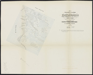
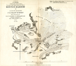
A Chart Exhibiting the Normal Course & Velocity of the Tidal Current at Ebb in Boston Harbor
46.
A chart exhibiting the normal course & velocity of the tidal current at ebb in Boston Harbor
47.
Chart of Boston Harbor : from the best authorities, 1873
48.
Chart of Boston Harbor and Massachusetts Bay : with map of the adjacent country
49.
[Chart of Boston Harbor and the surrounding areas]
50.
Copy of a plan of South Bay
51.
Copy of part of plan of inner harbor of Boston, showing commissioners' lines
52.
Eldridge's new chart no. 4 Boston Harbor : compiled from the latest surveys
53.
Extract from the plan of the coast survey of Boston Harbor, 1847
54.
The Harbor Park system
55.
J. Schedler's relief map of Boston and environs
56.
Map of Boston Harbor : showing commissioners' lines, wharves &c
57.
Map of Boston Harbor
58.
Map of Boston inner harbor
59.
Map of Boston proper, Charlestown, South Boston and East Boston : showing original territory of old Boston, the areas filled...
60.
Map of the eastern junc. Broad Sound Pier, & Pt. Shirley railroad : steamboat lines and connections : established for the...
61.
Map showing the routes of The Winthrop Steamboat Co
62.
Map showing the terminal facilities of Boston
63.
Plan for the occupation of flats owned by the Commonwealth in Boston Harbor
64.
Plan For the Occupation of the South Boston Flats by the Commissioners on the Harbors and Flats of Massachusetts
65.
Plan no. 2 for the occupation of the flats owned by the Commonwealth in Boston harbor: and for connecting the same with the...
66.
Plan of Boston and its vicinity
67.
Plan of Boston and its vicinity
68.
[Plan of channels and flats as they were before the 200 feet outside of the Mill Dam was filled up]
69.
Plan of location of projected ship canal from Taunton River to Boston Harbor, through Weymouth Fore River ... Frank W. Hodgdon,...
70.
Plan of main ship channel in Boston Harbor showing the work of removing certain obstructions to navigation
71.
Plan of South Bay showing the Harbor Commissioners lines
72.
Plan of South Boston flats: showing present condition and sketch of proposed docks and streets
73.
Plan of the harbour of Boston, from surveys made under the direction of commissioners appointed by a resolve of the...
74.
Plan showing encroachments upon the inner basins of Boston Harbor : accompanying annual report of Harbor and Land...
75.
[Plans of the South Bay]. Map A. Plan for the occupation of the South Boston flats
76.
[Plans of the South Bay]. Map B. Plan of the first section for the occupation of the South Boston flats
77.
[Plans of the South Bay]. Map C. Plan of South Bay showing changes in the Harbor Commissioners Lines
78.
Port facilities at Boston, MA
79.
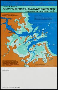
Science & policy of Boston Harbor symposium poster
80.
Sections of soundings made by order of the Harbor Committee of 1852
81.
Sketch of the narrows in Boston Harbor
82.
The able doctor; or America swallowing the bitter draught
83.
An accurate map of North America : describing and distinguishing the British and Spanish dominions on this great continent :...
84.
An accurate map of the four New England states : shewing in a distinct manner all the mountains, forts, rivers, swamps,...
85.
An actual survey of the sea coast from New York to the I. Cape Brition : with tables of the direct and thwart courses &...
86.
Americae siue noui orbis, noua descriptio
87.
Americae siue noui orbis, noua descriptio
88.
Baye et port de Boston
89.
Belgii Novi, Angliae Novae, et partis Virginiae : novissima delineatio
90.
Boston
91.
Boston
92.
Boston
93.
Boston and adjacent cities
94.
Boston and its environs
95.
Boston and surroundings
96.
Boston et ses environs
97.
Boston Harbour in New England
98.
Boston I
99.
Boston II
100.
Boston, its environs and harbour, with the rebels works raised against that town in 1775
« Previous
Next »
1
2
3
Limit your search
Subject
Boston Harbor (Mass.)--Maps
73
Boston (Mass.)--Maps
36
New England--Maps--Early works to 1800
23
World maps--Early works to 1800
19
Harbors--Massachusetts--Boston--Maps
18
Nautical charts--Massachusetts--Boston Harbor
17
Boston (Mass.)--History--Revolution, 1775-1783--Maps--Early works to 1800
16
Boston Harbor (Mass.)--Maps--Early works to 1800
13
more
Subject
»
Place
North and Central America
173
United States
146
Boston Harbor
77
Boston
74
Suffolk (county)
74
Massachusetts
30
New England
30
World
19
more
Place
»
Format
Maps/Atlases
206
Posters
1
Prints
1
Available to use
Creative Commons license
137
No known restrictions
52
Date
View distribution
Current results range from
1493
to
1985
Date range begin
Date range end
View larger »
Unknown
1
Collection
Norman B. Leventhal Map Center Collection
187
Mapping Boston Collection
139
Boston and New England Maps (Collection of Distinction)
117
American Revolutionary War-Era Maps (Collection of Distinction)
35
Maritime Charts and Atlases (Collection of Distinction)
35
Urban Maps (Collection of Distinction)
27
Historic Maps
9
Massachusetts Board of Harbor and Land Commissioners
8
more
Collection
»
Institution
Private Collection
139
Boston Public Library
50
Salem State University Archives and Special Collections
9
State Library of Massachusetts
8
American Antiquarian Society
1


![[Chart of Boston Harbor and the surrounding areas]](https://bpldcassets.blob.core.windows.net/derivatives/images/commonwealth:6108vs71d/image_thumbnail_300.jpg)


![[Plan of channels and flats as they were before the 200 feet outside of the Mill Dam was filled up]](https://bpldcassets.blob.core.windows.net/derivatives/images/commonwealth:b8516207x/image_thumbnail_300.jpg)


![[Plans of the South Bay]. Map A. Plan for the occupation of the South Boston flats](https://bpldcassets.blob.core.windows.net/derivatives/metadata/commonwealth-oai:m039km391/image_thumbnail_300.jpg)
![[Plans of the South Bay]. Map B. Plan of the first section for the occupation of the South Boston flats](https://bpldcassets.blob.core.windows.net/derivatives/metadata/commonwealth-oai:f1882318v/image_thumbnail_300.jpg)
![[Plans of the South Bay]. Map C. Plan of South Bay showing changes in the Harbor Commissioners Lines](https://bpldcassets.blob.core.windows.net/derivatives/metadata/commonwealth-oai:kw52jr44j/image_thumbnail_300.jpg)