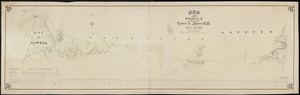
Skip to search
Skip to main content
Skip to first result
Digital Commonwealth
Folders
Sign Up / Log In
Search for
Search
Search
Search
Basic
Advanced
Explore
Map
Collections
Institutions
Formats
For Educators
Primary Source Sets
Lesson Plans
Using Primary Sources
Searching Digital Commonwealth
For Institutions
Join Digital Commonwealth
Conferences, Trainings, & Events
How to Contribute Collections
Digitization Services
Board & Committees
Frequently Asked Questions
About
About Digital Commonwealth
News & Announcements
Copyright & Terms of Use
Harmful Content Statement
Partners
API
Contact Us
Search
Search Constraints
Start Over
Save Search
Your search:
More Like
commonwealth:wd3761962
✖
Remove constraint More Like: commonwealth:wd3761962
« Prev. |
1
-
20
of
11,009
|
Next »
Sort
by relevance
relevance
title
date (asc)
date (desc)
Number of results to display per page
20
per page
per page
10
per page
20
per page
50
per page
100
per page
View results as:
List
list view
Maps
map view
Gallery
grid view
Search Results
1.
Atlas of the City of Lowell, Massachusetts : based upon and carefully compiled from the triangulation surveys, and maps in the...
2.
City of Lowell
3.
Part of an estate in Lowell, the property of Sarah C. Livermore
4.
Plan of land in Ayers' New-City, Lowell, Mass : belonging to Daniel Ayer
5.
Plan of the town of Lowell and Belvidere Village
6.
Property atlas of city of Lowell, northern district, Middlesex County, Massachusetts, showing the entire city complete in one...
7.
Atlas of Massachusetts
8.
Atlas of the boundaries of the city of Lowell and towns of Ayer, Billerica, Carlisle, Chelmsford, Dracut, Dunstable, Groton,...
9.
Atlas of the city of Lowell, Massachusetts
10.
Atlas of the city of Lowell, Massachusetts
11.
City atlas of Lowell, Massachusetts
12.
Map and profile of the Lowell & Andover R.R. built A.D. 1874
13.
Map and profiles of the railroad surveys from Lowell to North Andover
14.
[Map of Boston and Lowell and Nashua and Lowell Railroads near the Lowell depot]
15.
Plan of proposed branch R.R. from Lowell and Lawrence R.R. to Lowell Bleachery and Lawrence Street.
16.
Richards standard atlas of the city of Lowell, Massachusetts
17.
The 100th anniversary map of Abraham Lincoln's visit to Massachusetts, September 11-23, 1848
18.
1630 shoreline
19.
1879. Progress map of the U.S. Geographical Surveys west of the 100th Meridian : prepared under the direction of 1st Lieut....
20.
1903 Map of Salem and surrounding places
« Previous
Next »
1
2
3
4
5
…
550
551
Limit your search
Subject
Real property--Massachusetts--Boston--Maps
2,278
Landowners--Massachusetts--Boston--Maps
2,117
Boston (Mass.)--Maps
1,967
Roxbury (Boston, Mass.)--Maps
351
Dorchester (Boston, Mass.)--Maps
317
Cambridge (Mass.)--Maps
266
Brookline (Mass.)--Maps
236
Real property--Massachusetts--Cambridge--Maps
216
more
Subject
»
Place
North and Central America
7,823
United States
6,441
Suffolk (county)
3,337
Boston
3,197
Massachusetts
3,171
Europe
963
Middlesex (county)
625
Canada
427
more
Place
»
Format
Maps/Atlases
10,950
Manuscripts
215
Prints
51
Books
35
Objects/Artifacts
10
Drawings/Illustrations
8
Posters
4
Available to use
No known restrictions
10,931
Creative Commons license
46
Date
View distribution
Current results range from
1482
to
2023
Date range begin
Date range end
View larger »
Unknown
2
Collection
Norman B. Leventhal Map Center Collection
10,999
Boston and New England Maps (Collection of Distinction)
5,104
Urban Maps (Collection of Distinction)
4,845
Maritime Charts and Atlases (Collection of Distinction)
750
American Revolutionary War-Era Maps (Collection of Distinction)
615
Boston Redevelopment Authority Collection
86
Massachusetts Real Estate Atlases
5
Massachusetts Board of Railroad Commissioners
4
more
Collection
»
Institution
Boston Public Library
10,999
State Library of Massachusetts
10