Skip to search
Skip to main content
Skip to first result
Digital Commonwealth
Folders
Sign Up / Log In
Search for
Search
Search
Search
Basic
Advanced
Explore
Map
Collections
Institutions
Formats
For Educators
Primary Source Sets
Lesson Plans
Using Primary Sources
Searching Digital Commonwealth
For Institutions
Join Digital Commonwealth
Conferences, Trainings, & Events
How to Contribute Collections
Digitization Services
Board & Committees
Frequently Asked Questions
About
About Digital Commonwealth
News & Announcements
Copyright & Terms of Use
Harmful Content Statement
Partners
API
Contact Us
Search
Search Constraints
Start Over
Save Search
Your search:
More Like
commonwealth:w9505r79m
✖
Remove constraint More Like: commonwealth:w9505r79m
« Prev.
|
8,821
-
8,840
of
11,020
|
Next »
Sort
by relevance
relevance
title
date (asc)
date (desc)
Number of results to display per page
20
per page
per page
10
per page
20
per page
50
per page
100
per page
View results as:
List
list view
Maps
map view
Gallery
grid view
Search Results
8821.
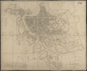
Plan of Rome
8822.
Plan of Rowe's Wharf
8823.
Plan of Rutland, Rutland County, Vermont
8824.
[Plan of Salem Common]
8825.
[Plan of section of proposed Charles River Park]
8826.
Plan of sections of 1, 2 & 3, East Boston
8827.
Plan of Sesuit Harbor in East Dennis : under chapter 32 resolves of 1907
8828.
Plan of Shakspeare's birth-place
8829.
Plan of Sherburne Bluffs, Nantucket, Mass
8830.
Plan of site for new court house on Pemberton Sq. and Somerset St. for the County of Suffolk : taken by authority of Chapter 377
8831.
Plan of Sorrento, Maine
8832.
Plan of South Bay showing the Harbor Commissioners lines
8833.
Plan of South Boston
8834.
A plan of South Boston and the owners lands, and the roads, taken from the original plan now in keeping, being the same plan...
8835.
Plan of Springfield
8836.
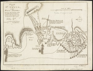
Plan of St. Lucia, in the West Indies : shewing the positions of the English and French forces with the attacks made at its...
8837.
Plan of Stephen W. and Francis Jackson's farm in Newton, 6 1/2 miles from Boston
8838.
Plan of store lots near Haymarket Square : belonging to the estate of Josiah Quincy Jr. : to be sold by public auction on...
8839.
Plan of Suffolk Street District : showing estates & buildings as proposed to be taken by the City of Boston under the Act of...
8840.
A plan of sundry farms etc. at Patucket in the town of Chelmsford
« Previous
Next »
1
2
…
438
439
440
441
442
443
444
445
446
…
550
551
Limit your search
Subject
Real property--Massachusetts--Boston--Maps
2,278
Landowners--Massachusetts--Boston--Maps
2,117
Boston (Mass.)--Maps
1,966
Roxbury (Boston, Mass.)--Maps
351
Dorchester (Boston, Mass.)--Maps
317
Cambridge (Mass.)--Maps
266
Brookline (Mass.)--Maps
236
Real property--Massachusetts--Cambridge--Maps
216
more
Subject
»
Place
North and Central America
7,821
United States
6,434
Suffolk (county)
3,337
Boston
3,197
Massachusetts
3,166
Europe
963
Middlesex (county)
617
Canada
428
more
Place
»
Format
Maps/Atlases
10,961
Manuscripts
215
Prints
51
Books
35
Objects/Artifacts
10
Drawings/Illustrations
8
Posters
4
Available to use
No known restrictions
10,931
Creative Commons license
57
Date
View distribution
Current results range from
1482
to
2023
Date range begin
Date range end
View larger »
Collection
Norman B. Leventhal Map Center Collection
11,008
Boston and New England Maps (Collection of Distinction)
5,105
Urban Maps (Collection of Distinction)
4,846
Maritime Charts and Atlases (Collection of Distinction)
750
American Revolutionary War-Era Maps (Collection of Distinction)
621
Boston Redevelopment Authority Collection
86
Mapping Boston Collection
9
Sidney R. Knafel Map Collection at Phillips Academy
8
more
Collection
»
Institution
Boston Public Library
10,999
Private Collection
9
Phillips Academy
8
Boston Athenaeum
2
Massachusetts Historical Society
1
Salem State University Archives and Special Collections
1

![[Plan of Salem Common]](https://bpldcassets.blob.core.windows.net/derivatives/images/commonwealth:9s161g70k/image_thumbnail_300.jpg)
![[Plan of section of proposed Charles River Park]](https://bpldcassets.blob.core.windows.net/derivatives/images/commonwealth:x059cc51b/image_thumbnail_300.jpg)