Search
Search Results
- Creator:
- Massachusetts. Metropolitan District Water Supply Commission; Barbier, Ernest E., 1912-2007
- Format:
- Photographs
- Collection:
- Massachusetts Metropolitan District Water Supply Commission, Quabbin Reservoir, Photographs of Real Estate in the Swift River Valley, and of General Engineering of Quabbin Reservoir, 1927-1950
- Date:
- June 22, 1946
- Institution:
- Massachusetts Archives
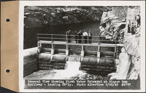
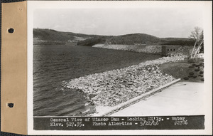
- Creator:
- Massachusetts. Metropolitan District Water Supply Commission; Albertine, Louis G., 1908-1998
- Format:
- Photographs
- Collection:
- Massachusetts Metropolitan District Water Supply Commission, Quabbin Reservoir, Photographs of Real Estate in the Swift River Valley, and of General Engineering of Quabbin Reservoir, 1927-1950
- Date:
- June 22, 1946
- Institution:
- Massachusetts Archives
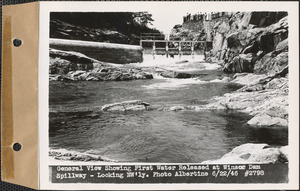
- Creator:
- Massachusetts. Metropolitan District Water Supply Commission; Barbier, Ernest E., 1912-2007
- Format:
- Photographs
- Collection:
- Massachusetts Metropolitan District Water Supply Commission, Quabbin Reservoir, Photographs of Real Estate in the Swift River Valley, and of General Engineering of Quabbin Reservoir, 1927-1950
- Date:
- June 22, 1946
- Institution:
- Massachusetts Archives
- Creator:
- Massachusetts. Metropolitan District Water Supply Commission; Albertine, Louis G., 1908-1998
- Format:
- Photographs
- Collection:
- Massachusetts Metropolitan District Water Supply Commission, Quabbin Reservoir, Photographs of Real Estate in the Swift River Valley, and of General Engineering of Quabbin Reservoir, 1927-1950
- Date:
- June 5, 1946
- Institution:
- Massachusetts Archives
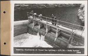
- Creator:
- Massachusetts. Metropolitan District Water Supply Commission; Albertine, Louis G., 1908-1998
- Format:
- Photographs
- Collection:
- Massachusetts Metropolitan District Water Supply Commission, Quabbin Reservoir, Photographs of Real Estate in the Swift River Valley, and of General Engineering of Quabbin Reservoir, 1927-1950
- Date:
- August 21, 1946
- Institution:
- Massachusetts Archives
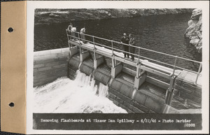
- Creator:
- Massachusetts. Metropolitan District Water Supply Commission; Albertine, Louis G., 1908-1998
- Format:
- Photographs
- Collection:
- Massachusetts Metropolitan District Water Supply Commission, Quabbin Reservoir, Photographs of Real Estate in the Swift River Valley, and of General Engineering of Quabbin Reservoir, 1927-1950
- Date:
- August 21, 1946
- Institution:
- Massachusetts Archives
- Creator:
- Massachusetts. Metropolitan District Water Supply Commission; Albertine, Louis G., 1908-1998
- Format:
- Photographs
- Collection:
- Massachusetts Metropolitan District Water Supply Commission, Quabbin Reservoir, Photographs of Real Estate in the Swift River Valley, and of General Engineering of Quabbin Reservoir, 1927-1950
- Date:
- May 22, 1946
- Institution:
- Massachusetts Archives
- Creator:
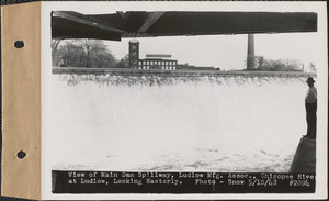
- Massachusetts. Metropolitan District Commission. Water Division; Snow, Russell, 1902-1969
- Format:
- Photographs
- Collection:
- Massachusetts Metropolitan District Water Supply Commission, Quabbin Reservoir, Photographs of Real Estate in the Swift River Valley, and of General Engineering of Quabbin Reservoir, 1927-1950
- Date:
- May 10, 1948
- Institution:
- Massachusetts Archives
- Creator:
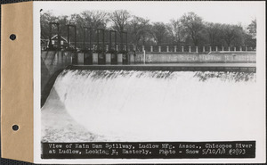
- Massachusetts. Metropolitan District Commission. Water Division; Snow, Russell, 1902-1969
- Format:
- Photographs
- Collection:
- Massachusetts Metropolitan District Water Supply Commission, Quabbin Reservoir, Photographs of Real Estate in the Swift River Valley, and of General Engineering of Quabbin Reservoir, 1927-1950
- Date:
- May 10, 1948
- Institution:
- Massachusetts Archives
- Creator:
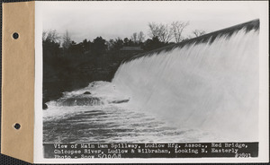
- Massachusetts. Metropolitan District Commission. Water Division; Snow, Russell, 1902-1969
- Format:
- Photographs
- Collection:
- Massachusetts Metropolitan District Water Supply Commission, Quabbin Reservoir, Photographs of Real Estate in the Swift River Valley, and of General Engineering of Quabbin Reservoir, 1927-1950
- Date:
- May 10, 1948
- Institution:
- Massachusetts Archives
- Creator:
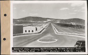
- Massachusetts. Metropolitan District Water Supply Commission; Barbier, Ernest E., 1912-2007
- Format:
- Photographs
- Collection:
- Massachusetts Metropolitan District Water Supply Commission, Quabbin Reservoir, Photographs of Real Estate in the Swift River Valley, and of General Engineering of Quabbin Reservoir, 1927-1950
- Date:
- May 12, 1941
- Institution:
- Massachusetts Archives
- Creator:
- Massachusetts. Metropolitan District Water Supply Commission; Albertine, Louis G., 1908-1998
- Format:
- Photographs
- Collection:
- Massachusetts Metropolitan District Water Supply Commission, Quabbin Reservoir, Photographs of Real Estate in the Swift River Valley, and of General Engineering of Quabbin Reservoir, 1927-1950
- Date:
- May 22, 1946
- Institution:
- Massachusetts Archives
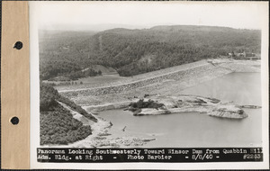
- Creator:
- Massachusetts. Metropolitan District Water Supply Commission; Barbier, Ernest E., 1912-2007
- Format:
- Photographs
- Collection:
- Massachusetts Metropolitan District Water Supply Commission, Quabbin Reservoir, Photographs of Real Estate in the Swift River Valley, and of General Engineering of Quabbin Reservoir, 1927-1950
- Date:
- August 8, 1940
- Institution:
- Massachusetts Archives
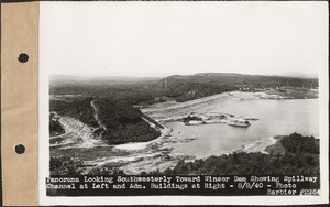
- Creator:
- Massachusetts. Metropolitan District Water Supply Commission; Barbier, Ernest E., 1912-2007
- Format:
- Photographs
- Collection:
- Massachusetts Metropolitan District Water Supply Commission, Quabbin Reservoir, Photographs of Real Estate in the Swift River Valley, and of General Engineering of Quabbin Reservoir, 1927-1950
- Date:
- August 8, 1940
- Institution:
- Massachusetts Archives
- Creator:
- Massachusetts. Metropolitan District Water Supply Commission
- Format:
- Photographs
- Collection:
- Massachusetts Metropolitan District Water Supply Commission, Quabbin Reservoir, Photographs of Real Estate in the Swift River Valley, and of General Engineering of Quabbin Reservoir, 1927-1950
- Date:
- [ca. 1941]
- Institution:
- Massachusetts Archives
- Creator:
- Massachusetts. Metropolitan District Water Supply Commission; Barbier, Ernest E., 1912-2007
- Format:
- Photographs
- Collection:
- Massachusetts Metropolitan District Water Supply Commission, Quabbin Reservoir, Photographs of Real Estate in the Swift River Valley, and of General Engineering of Quabbin Reservoir, 1927-1950
- Date:
- June 12, 1941
- Institution:
- Massachusetts Archives
- Creator:
- Massachusetts. Metropolitan District Water Supply Commission; Barbier, Ernest E., 1912-2007
- Format:
- Photographs
- Collection:
- Massachusetts Metropolitan District Water Supply Commission, Quabbin Reservoir, Photographs of Real Estate, Sanitary Conditions, and Flooding in the Ware River Watershed, and of General Engineering, 1928-1948
- Date:
- September 17, 1941
- Institution:
- Massachusetts Archives
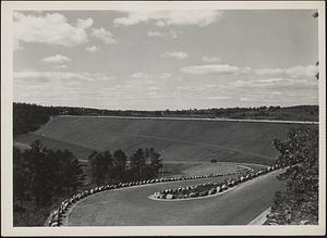
- Creator:
- Massachusetts. Metropolitan District Water Supply Commission; Thornquist, Russell C., 1909-1976
- Format:
- Photographs
- Collection:
- Massachusetts Metropolitan District Water Supply Commission, Quabbin Reservoir, Photographs of Contract Construction (selections from), 1928-1947
- Date:
- May 20, 1936
- Institution:
- Massachusetts Archives
- Creator:
- Massachusetts. Metropolitan District Water Supply Commission; Troland, Edwin Parker, 1914-2004
- Format:
- Photographs
- Collection:
- Massachusetts Metropolitan District Water Supply Commission, Quabbin Reservoir, Photographs of Contract Construction (selections from), 1928-1947
- Date:
- July 23, 1940
- Institution:
- Massachusetts Archives
- Creator:
- Massachusetts. Metropolitan District Water Supply Commission; Barbier, Ernest E., 1912-2007
- Format:
- Photographs
- Collection:
- Massachusetts Metropolitan District Water Supply Commission, Quabbin Reservoir, Photographs of Real Estate in the Swift River Valley, and of General Engineering of Quabbin Reservoir, 1927-1950
- Date:
- January 7, 1941
- Institution:
- Massachusetts Archives
- Creator:
- Massachusetts. Metropolitan District Commission. Water Division; Snow, Russell, 1902-1969
- Format:
- Photographs
- Collection:
- Massachusetts Metropolitan District Water Supply Commission, Quabbin Reservoir, Photographs of Real Estate in the Swift River Valley, and of General Engineering of Quabbin Reservoir, 1927-1950
- Date:
- May 10, 1948
- Institution:
- Massachusetts Archives
- Creator:
- Massachusetts. Metropolitan District Water Supply Commission; Albertine, Louis G., 1908-1998
- Format:
- Photographs
- Collection:
- Massachusetts Metropolitan District Water Supply Commission, Quabbin Reservoir, Photographs of Real Estate in the Swift River Valley, and of General Engineering of Quabbin Reservoir, 1927-1950
- Date:
- May 15, 1947
- Institution:
- Massachusetts Archives
- Creator:
- Massachusetts. Metropolitan District Water Supply Commission; Pike, Stuart D., 1910-1978
- Format:
- Photographs
- Collection:
- Massachusetts Metropolitan District Water Supply Commission, Quabbin Reservoir, Photographs of Real Estate in the Swift River Valley, and of General Engineering of Quabbin Reservoir, 1927-1950
- Date:
- November 29, 1939
- Institution:
- Massachusetts Archives
- Creator:
- Massachusetts. Metropolitan District Water Supply Commission
- Format:
- Photographs
- Collection:
- Massachusetts Metropolitan District Water Supply Commission, Quabbin Reservoir, Photographs of Real Estate in the Swift River Valley, and of General Engineering of Quabbin Reservoir, 1927-1950
- Date:
- August 1945
- Institution:
- Massachusetts Archives
- Creator:
- Massachusetts. Metropolitan District Water Supply Commission; Albertine, Louis G., 1908-1998
- Format:
- Photographs
- Collection:
- Massachusetts Metropolitan District Water Supply Commission, Quabbin Reservoir, Photographs of Real Estate in the Swift River Valley, and of General Engineering of Quabbin Reservoir, 1927-1950
- Date:
- August 21, 1946
- Institution:
- Massachusetts Archives
- Creator:
- Massachusetts. Metropolitan District Water Supply Commission; Albertine, Louis G., 1908-1998
- Format:
- Photographs
- Collection:
- Massachusetts Metropolitan District Water Supply Commission, Quabbin Reservoir, Photographs of Real Estate in the Swift River Valley, and of General Engineering of Quabbin Reservoir, 1927-1950
- Date:
- October 3, 1945
- Institution:
- Massachusetts Archives
- Creator:
- Massachusetts. Metropolitan District Water Supply Commission; Albertine, Louis G., 1908-1998
- Format:
- Photographs
- Collection:
- Massachusetts Metropolitan District Water Supply Commission, Quabbin Reservoir, Photographs of Real Estate in the Swift River Valley, and of General Engineering of Quabbin Reservoir, 1927-1950
- Date:
- October 17, 1945
- Institution:
- Massachusetts Archives
- Creator:
- Massachusetts. Metropolitan District Water Supply Commission; Albertine, Louis G., 1908-1998
- Format:
- Photographs
- Collection:
- Massachusetts Metropolitan District Water Supply Commission, Quabbin Reservoir, Photographs of Real Estate in the Swift River Valley, and of General Engineering of Quabbin Reservoir, 1927-1950
- Date:
- May 22, 1946
- Institution:
- Massachusetts Archives
- Creator:
- Massachusetts. Metropolitan District Water Supply Commission
- Format:
- Photographs
- Collection:
- Massachusetts Metropolitan District Water Supply Commission, Quabbin Reservoir, Photographs of Real Estate in the Swift River Valley, and of General Engineering of Quabbin Reservoir, 1927-1950
- Date:
- [ca. 1942]
- Institution:
- Massachusetts Archives
- Creator:
- Massachusetts. Metropolitan District Water Supply Commission; Albertine, Louis G., 1908-1998
- Format:
- Photographs
- Collection:
- Massachusetts Metropolitan District Water Supply Commission, Quabbin Reservoir, Photographs of Real Estate in the Swift River Valley, and of General Engineering of Quabbin Reservoir, 1927-1950
- Date:
- June 5, 1946
- Institution:
- Massachusetts Archives
- Creator:
- Massachusetts. Metropolitan District Water Supply Commission; Albertine, Louis G., 1908-1998
- Format:
- Photographs
- Collection:
- Massachusetts Metropolitan District Water Supply Commission, Quabbin Reservoir, Photographs of Real Estate in the Swift River Valley, and of General Engineering of Quabbin Reservoir, 1927-1950
- Date:
- June 4, 1946
- Institution:
- Massachusetts Archives
- Creator:
- Massachusetts. Metropolitan District Water Supply Commission
- Format:
- Photographs
- Collection:
- Massachusetts Metropolitan District Water Supply Commission, Quabbin Reservoir, Photographs of Real Estate in the Swift River Valley, and of General Engineering of Quabbin Reservoir, 1927-1950
- Date:
- August 1941
- Institution:
- Massachusetts Archives
- Creator:
- Massachusetts. Metropolitan District Water Supply Commission; Albertine, Louis G., 1908-1998
- Format:
- Photographs
- Collection:
- Massachusetts Metropolitan District Water Supply Commission, Quabbin Reservoir, Photographs of Real Estate in the Swift River Valley, and of General Engineering of Quabbin Reservoir, 1927-1950
- Date:
- June 5, 1946
- Institution:
- Massachusetts Archives
- Creator:
- Massachusetts. Metropolitan District Water Supply Commission; Albertine, Louis G., 1908-1998
- Format:
- Photographs
- Collection:
- Massachusetts Metropolitan District Water Supply Commission, Quabbin Reservoir, Photographs of Real Estate in the Swift River Valley, and of General Engineering of Quabbin Reservoir, 1927-1950
- Date:
- May 22, 1946
- Institution:
- Massachusetts Archives
- Creator:
- Massachusetts. Metropolitan District Water Supply Commission; Albertine, Louis G., 1908-1998
- Format:
- Photographs
- Collection:
- Massachusetts Metropolitan District Water Supply Commission, Quabbin Reservoir, Photographs of Real Estate in the Swift River Valley, and of General Engineering of Quabbin Reservoir, 1927-1950
- Date:
- October 3, 1945
- Institution:
- Massachusetts Archives
- Creator:
- Massachusetts. Metropolitan District Water Supply Commission; Pike, Stuart D., 1910-1978
- Format:
- Photographs
- Collection:
- Massachusetts Metropolitan District Water Supply Commission, Quabbin Reservoir, Photographs of Real Estate in the Swift River Valley, and of General Engineering of Quabbin Reservoir, 1927-1950
- Date:
- October 23, 1939
- Institution:
- Massachusetts Archives
- Creator:
- Massachusetts. Metropolitan District Water Supply Commission; Pike, Stuart D., 1910-1978
- Format:
- Photographs
- Collection:
- Massachusetts Metropolitan District Water Supply Commission, Quabbin Reservoir, Photographs of Real Estate in the Swift River Valley, and of General Engineering of Quabbin Reservoir, 1927-1950
- Date:
- April 10, 1940
- Institution:
- Massachusetts Archives
- Creator:
- Massachusetts. Metropolitan District Water Supply Commission; Pike, Stuart D., 1910-1978
- Format:
- Photographs
- Collection:
- Massachusetts Metropolitan District Water Supply Commission, Quabbin Reservoir, Photographs of Real Estate in the Swift River Valley, and of General Engineering of Quabbin Reservoir, 1927-1950
- Date:
- November 14, 1939
- Institution:
- Massachusetts Archives
- Creator:
- Massachusetts. Metropolitan District Water Supply Commission; Pike, Stuart D., 1910-1978
- Format:
- Photographs
- Collection:
- Massachusetts Metropolitan District Water Supply Commission, Quabbin Reservoir, Photographs of Real Estate in the Swift River Valley, and of General Engineering of Quabbin Reservoir, 1927-1950
- Date:
- April 10, 1940
- Institution:
- Massachusetts Archives
- Creator:
- Massachusetts. Metropolitan District Water Supply Commission; Pike, Stuart D., 1910-1978
- Format:
- Photographs
- Collection:
- Massachusetts Metropolitan District Water Supply Commission, Quabbin Reservoir, Photographs of Real Estate in the Swift River Valley, and of General Engineering of Quabbin Reservoir, 1927-1950
- Date:
- November 14, 1939
- Institution:
- Massachusetts Archives
- Creator:
- Massachusetts. Metropolitan District Water Supply Commission; Pike, Stuart D., 1910-1978
- Format:
- Photographs
- Collection:
- Massachusetts Metropolitan District Water Supply Commission, Quabbin Reservoir, Photographs of Real Estate in the Swift River Valley, and of General Engineering of Quabbin Reservoir, 1927-1950
- Date:
- April 10, 1940
- Institution:
- Massachusetts Archives
- Creator:
- Massachusetts. Metropolitan District Water Supply Commission; Pike, Stuart D., 1910-1978
- Format:
- Photographs
- Collection:
- Massachusetts Metropolitan District Water Supply Commission, Quabbin Reservoir, Photographs of Real Estate in the Swift River Valley, and of General Engineering of Quabbin Reservoir, 1927-1950
- Date:
- August 23, 1939
- Institution:
- Massachusetts Archives
- Creator:
- Massachusetts. Metropolitan District Water Supply Commission; Pike, Stuart D., 1910-1978
- Format:
- Photographs
- Collection:
- Massachusetts Metropolitan District Water Supply Commission, Quabbin Reservoir, Photographs of Real Estate in the Swift River Valley, and of General Engineering of Quabbin Reservoir, 1927-1950
- Date:
- November 3, 1939
- Institution:
- Massachusetts Archives
- Creator:
- Massachusetts. Metropolitan District Water Supply Commission; Pike, Stuart D., 1910-1978
- Format:
- Photographs
- Collection:
- Massachusetts Metropolitan District Water Supply Commission, Quabbin Reservoir, Photographs of Real Estate in the Swift River Valley, and of General Engineering of Quabbin Reservoir, 1927-1950
- Date:
- August 23, 1939
- Institution:
- Massachusetts Archives
- Creator:
- Massachusetts. Metropolitan District Water Supply Commission; Pike, Stuart D., 1910-1978
- Format:
- Photographs
- Collection:
- Massachusetts Metropolitan District Water Supply Commission, Quabbin Reservoir, Photographs of Real Estate in the Swift River Valley, and of General Engineering of Quabbin Reservoir, 1927-1950
- Date:
- August 14, 1939
- Institution:
- Massachusetts Archives
- Creator:
- Massachusetts. Metropolitan District Water Supply Commission; Pike, Stuart D., 1910-1978
- Format:
- Photographs
- Collection:
- Massachusetts Metropolitan District Water Supply Commission, Quabbin Reservoir, Photographs of Real Estate in the Swift River Valley, and of General Engineering of Quabbin Reservoir, 1927-1950
- Date:
- September 1, 1939
- Institution:
- Massachusetts Archives
- Creator:
- Massachusetts. Metropolitan District Water Supply Commission; Barbier, Ernest E., 1912-2007
- Format:
- Photographs
- Collection:
- Massachusetts Metropolitan District Water Supply Commission, Quabbin Reservoir, Photographs of Real Estate in the Swift River Valley, and of General Engineering of Quabbin Reservoir, 1927-1950
- Date:
- October 15, 1941
- Institution:
- Massachusetts Archives
- Creator:
- Massachusetts. Metropolitan District Water Supply Commission; Pike, Stuart D., 1910-1978
- Format:
- Photographs
- Collection:
- Massachusetts Metropolitan District Water Supply Commission, Quabbin Reservoir, Photographs of Real Estate in the Swift River Valley, and of General Engineering of Quabbin Reservoir, 1927-1950
- Date:
- August 23, 1939
- Institution:
- Massachusetts Archives
- Creator:
- Massachusetts. Metropolitan District Water Supply Commission; Pike, Stuart D., 1910-1978
- Format:
- Photographs
- Collection:
- Massachusetts Metropolitan District Water Supply Commission, Quabbin Reservoir, Photographs of Real Estate in the Swift River Valley, and of General Engineering of Quabbin Reservoir, 1927-1950
- Date:
- November 3, 1939
- Institution:
- Massachusetts Archives
- Creator:
- Massachusetts. Metropolitan District Water Supply Commission; Pike, Stuart D., 1910-1978
- Format:
- Photographs
- Collection:
- Massachusetts Metropolitan District Water Supply Commission, Quabbin Reservoir, Photographs of Real Estate in the Swift River Valley, and of General Engineering of Quabbin Reservoir, 1927-1950
- Date:
- August 23, 1939
- Institution:
- Massachusetts Archives
- Creator:
- Massachusetts. Metropolitan District Water Supply Commission; Pike, Stuart D., 1910-1978
- Format:
- Photographs
- Collection:
- Massachusetts Metropolitan District Water Supply Commission, Quabbin Reservoir, Photographs of Real Estate in the Swift River Valley, and of General Engineering of Quabbin Reservoir, 1927-1950
- Date:
- April 10, 1940
- Institution:
- Massachusetts Archives
- Creator:
- Massachusetts. Metropolitan District Water Supply Commission; Pike, Stuart D., 1910-1978
- Format:
- Photographs
- Collection:
- Massachusetts Metropolitan District Water Supply Commission, Quabbin Reservoir, Photographs of Real Estate in the Swift River Valley, and of General Engineering of Quabbin Reservoir, 1927-1950
- Date:
- November 14, 1939
- Institution:
- Massachusetts Archives
- Creator:
- Massachusetts. Metropolitan District Water Supply Commission; Barbier, Ernest E., 1912-2007
- Format:
- Photographs
- Collection:
- Massachusetts Metropolitan District Water Supply Commission, Quabbin Reservoir, Photographs of Real Estate in the Swift River Valley, and of General Engineering of Quabbin Reservoir, 1927-1950
- Date:
- July 28, 1941
- Institution:
- Massachusetts Archives
- Creator:
- Massachusetts. Metropolitan District Water Supply Commission; Pike, Stuart D., 1910-1978
- Format:
- Photographs
- Collection:
- Massachusetts Metropolitan District Water Supply Commission, Quabbin Reservoir, Photographs of Real Estate in the Swift River Valley, and of General Engineering of Quabbin Reservoir, 1927-1950
- Date:
- November 4, 1939
- Institution:
- Massachusetts Archives
- Creator:
- Massachusetts. Metropolitan District Water Supply Commission; Pike, Stuart D., 1910-1978
- Format:
- Photographs
- Collection:
- Massachusetts Metropolitan District Water Supply Commission, Quabbin Reservoir, Photographs of Real Estate in the Swift River Valley, and of General Engineering of Quabbin Reservoir, 1927-1950
- Date:
- April 23, 1940
- Institution:
- Massachusetts Archives
- Creator:
- Massachusetts. Metropolitan District Water Supply Commission; Pike, Stuart D., 1910-1978
- Format:
- Photographs
- Collection:
- Massachusetts Metropolitan District Water Supply Commission, Quabbin Reservoir, Photographs of Real Estate in the Swift River Valley, and of General Engineering of Quabbin Reservoir, 1927-1950
- Date:
- April 10, 1940
- Institution:
- Massachusetts Archives
- Creator:
- Massachusetts. Metropolitan District Water Supply Commission; Pike, Stuart D., 1910-1978
- Format:
- Photographs
- Collection:
- Massachusetts Metropolitan District Water Supply Commission, Quabbin Reservoir, Photographs of Real Estate in the Swift River Valley, and of General Engineering of Quabbin Reservoir, 1927-1950
- Date:
- May 8, 1940
- Institution:
- Massachusetts Archives
- Creator:
- Massachusetts. Metropolitan District Water Supply Commission; Pike, Stuart D., 1910-1978
- Format:
- Photographs
- Collection:
- Massachusetts Metropolitan District Water Supply Commission, Quabbin Reservoir, Photographs of Real Estate in the Swift River Valley, and of General Engineering of Quabbin Reservoir, 1927-1950
- Date:
- November 4, 1939
- Institution:
- Massachusetts Archives
- Creator:
- Massachusetts. Metropolitan District Water Supply Commission; Pike, Stuart D., 1910-1978
- Format:
- Photographs
- Collection:
- Massachusetts Metropolitan District Water Supply Commission, Quabbin Reservoir, Photographs of Real Estate in the Swift River Valley, and of General Engineering of Quabbin Reservoir, 1927-1950
- Date:
- April 29, 1940
- Institution:
- Massachusetts Archives
- Creator:
- Massachusetts. Metropolitan District Water Supply Commission; Pike, Stuart D., 1910-1978
- Format:
- Photographs
- Collection:
- Massachusetts Metropolitan District Water Supply Commission, Quabbin Reservoir, Photographs of Real Estate in the Swift River Valley, and of General Engineering of Quabbin Reservoir, 1927-1950
- Date:
- November 3, 1939
- Institution:
- Massachusetts Archives
- Creator:
- Massachusetts. Metropolitan District Water Supply Commission; Pike, Stuart D., 1910-1978
- Format:
- Photographs
- Collection:
- Massachusetts Metropolitan District Water Supply Commission, Quabbin Reservoir, Photographs of Real Estate in the Swift River Valley, and of General Engineering of Quabbin Reservoir, 1927-1950
- Date:
- August 26, 1939
- Institution:
- Massachusetts Archives
- Creator:
- Massachusetts. Metropolitan District Water Supply Commission; Pike, Stuart D., 1910-1978
- Format:
- Photographs
- Collection:
- Massachusetts Metropolitan District Water Supply Commission, Quabbin Reservoir, Photographs of Real Estate in the Swift River Valley, and of General Engineering of Quabbin Reservoir, 1927-1950
- Date:
- November 3, 1939
- Institution:
- Massachusetts Archives
- Creator:
- Massachusetts. Metropolitan District Water Supply Commission; Pike, Stuart D., 1910-1978
- Format:
- Photographs
- Collection:
- Massachusetts Metropolitan District Water Supply Commission, Quabbin Reservoir, Photographs of Real Estate in the Swift River Valley, and of General Engineering of Quabbin Reservoir, 1927-1950
- Date:
- August 14, 1939
- Institution:
- Massachusetts Archives
- Creator:
- Massachusetts. Metropolitan District Water Supply Commission; Pike, Stuart D., 1910-1978
- Format:
- Photographs
- Collection:
- Massachusetts Metropolitan District Water Supply Commission, Quabbin Reservoir, Photographs of Real Estate in the Swift River Valley, and of General Engineering of Quabbin Reservoir, 1927-1950
- Date:
- June 1, 1940
- Institution:
- Massachusetts Archives
- Creator:
- Massachusetts. Metropolitan District Water Supply Commission; Snow, Russell, 1902-1969
- Format:
- Photographs
- Collection:
- Massachusetts Metropolitan District Water Supply Commission, Quabbin Reservoir, Photographs of Real Estate in the Swift River Valley, and of General Engineering of Quabbin Reservoir, 1927-1950
- Date:
- September 22, 1942
- Institution:
- Massachusetts Archives