Skip to search
Skip to main content
Skip to first result
Digital Commonwealth
Folders
Sign Up / Log In
Search for
Search
Search
Search
Basic
Advanced
Explore
Map
Collections
Institutions
Formats
For Educators
Primary Source Sets
Lesson Plans
Using Primary Sources
Searching Digital Commonwealth
For Institutions
Join Digital Commonwealth
Conferences, Trainings, & Events
How to Contribute Collections
Digitization Services
Board & Committees
Frequently Asked Questions
About
About Digital Commonwealth
News & Announcements
Copyright & Terms of Use
Harmful Content Statement
Partners
API
Contact Us
Search
Search Constraints
Start Over
Save Search
Your search:
More Like
commonwealth:hq37vv66t
✖
Remove constraint More Like: commonwealth:hq37vv66t
« Prev. |
1
-
20
of
165
|
Next »
Sort
by relevance
relevance
title
date (asc)
date (desc)
Number of results to display per page
20
per page
per page
10
per page
20
per page
50
per page
100
per page
View results as:
List
list view
Maps
map view
Gallery
grid view
Search Results
1.
Typus orbis terrarum
2.
Airways of the world on Mercator's projection
3.
American Radiator Company trade card
4.
Bartholomew's chart of the world on Mercator's projection
5.
Caerte van de voornaemste reysen ende ontdeckingen door de Hollanders gedaen, alsook vande landen, plaetsen ende factoriën in...
6.
Carriers of the new black plague
7.
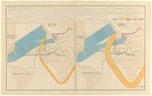
Carte figurative et approximative des quantités de coton en laine importées en Europe en 1858 et en 1861
8.
[Carte marine de la mer Baltique, de la mer du Nord, de l'océan Atlantique Est, de la mer Méditerranée, de la mer Noire et...
9.
A chart of the world, according to Mercators projection, shewing the latest discoveries of Capt. Cook
10.
Chart of the world, on Mercator's projection : illustrative of the impolicy of slavery
11.
Chart of the world showing area in the Pacific Ocean having Hawaii as the only base of supplies in transpacific voyages and...
12.
Chikyū bankoku hōzu
13.
Comparative view of the heights of the principal mountains &c. in the world
14.
Diagram to illustrate contrast between British and Chinese Empires
15.
Diqiu quan tu
16.
Eight views of the world
17.
Europe in search of new routes to India and China, 1486-1616 A.D.
18.
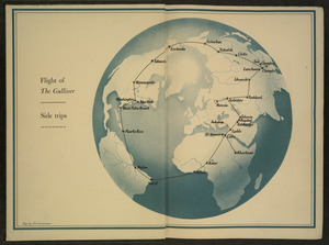
Flight of "The Gulliver"
19.
Gleason's new standard map of the world : on the projection of J. S. Christopher, Modern College, Blackheath, England ;...
20.
Great circle airways
« Previous
Next »
1
2
3
4
5
…
8
9
Limit your search
Subject
World maps
79
New England--Maps--Early works to 1800
15
World maps--Early works to 1800
13
America--Maps--Early works to 1800
9
Massachusetts--Maps
8
North America--Maps--Early works to 1800
8
Pictorial maps
8
Western Hemisphere--Maps--Early works to 1800
6
more
Subject
»
Place
World
76
North and Central America
47
New England
20
United States
18
Massachusetts
17
Rhode Island
8
New York
7
Connecticut
6
more
Place
»
Format
Maps/Atlases
164
Manuscripts
2
Books
1
Photographs
1
Available to use
No known restrictions
68
Creative Commons license
1
Date
View distribution
Current results range from
1482
to
2022
Date range begin
Date range end
View larger »
Collection
Sidney R. Knafel Map Collection at Phillips Academy
87
Norman B. Leventhal Map Center Collection
77
American Revolutionary War-Era Maps (Collection of Distinction)
26
Boston and New England Maps (Collection of Distinction)
1
Chinese Progressive Association Records
1
Urban Maps (Collection of Distinction)
1
Institution
Phillips Academy
87
Boston Public Library
77
Northeastern University Library
1


![[Carte marine de la mer Baltique, de la mer du Nord, de l'océan Atlantique Est, de la mer Méditerranée, de la mer Noire et de la mer Rouge]](https://bpldcassets.blob.core.windows.net/derivatives/images/commonwealth:4m90fm28z/image_thumbnail_300.jpg)