1. Map showing horse rail roads and the surface steam roads with 104 stations in and around Boston : including 91 surface steam r.r. stations within a radius of six miles... Format: Maps/Atlases Collection: Boston and New England Maps (Collection of Distinction) / Norman B. Leventhal Map Center Collection / Urban Maps (Collection of Distinction) Date: [1876] Institution: Boston Public Library
2. Rail road map : showing the street rail road routes in and leading from Boston, with the terminus of each road in suburban cities or towns Creator: Chase, J. G. Format: Maps/Atlases Collection: Boston and New England Maps (Collection of Distinction) / Norman B. Leventhal Map Center Collection / Urban Maps (Collection of Distinction) Date: 1865 Institution: Boston Public Library
3. Railroad map of all street and steam railroads in Boston and vicinity Creator: Chase, J. G. Format: Maps/Atlases Collection: Boston and New England Maps (Collection of Distinction) / Norman B. Leventhal Map Center Collection / Urban Maps (Collection of Distinction) Date: 1865 Institution: Boston Public Library
4. Boston I Creator: Wagner & Debes; Wagner & Debes Format: Maps/Atlases Collection: Mapping Boston Collection / Norman B. Leventhal Map Center Collection Date: [1906] Institution: Boston Public Library
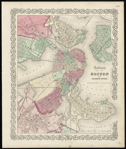
5. Colton's Map of Boston and Adjacent Cities. Creator: J.H. Colton & Co Format: Maps/Atlases Collection: Historic Maps Date: 1855 Institution: Salem State University Archives and Special Collections
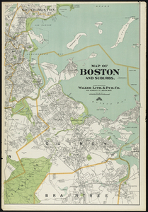
6. Map of Boston and Suburbs Creator: Walker Lith. & Pub. Co Format: Maps/Atlases Collection: Historic Maps Date: 1909 Institution: Salem State University Archives and Special Collections
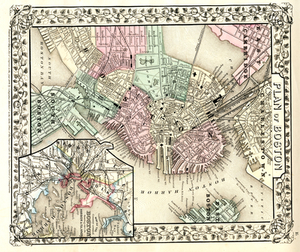
7. Plan of Boston. Creator: Mitchell, S. Augustus Format: Maps/Atlases Collection: Historic Maps Date: 1870 Institution: Salem State University Archives and Special Collections
8. Bay State Street Ry. Co's lines and connections Creator: Bay State Street Railway Company Format: Maps/Atlases Collection: Boston and New England Maps (Collection of Distinction) / Norman B. Leventhal Map Center Collection Date: [ca. 1917] Institution: Boston Public Library
9. Boston personal income ; Boston personal income [and] residential population density Creator: Passonneau, Joseph; Wurman, Richard Saul, 1935- Format: Maps/Atlases Collection: Boston and New England Maps (Collection of Distinction) / Norman B. Leventhal Map Center Collection Date: 1966 Institution: Boston Public Library
10. How we get around today Creator: Nelson, Garrett Dash; Boston Public Library. Norman B. Leventhal Map and Education Center Format: Maps/Atlases Collection: Boston and New England Maps (Collection of Distinction) / Norman B. Leventhal Map Center Collection Date: 2023 Institution: Boston Public Library


![Boston personal income ; Boston personal income [and] residential population density](https://bpldcassets.blob.core.windows.net/derivatives/images/commonwealth:fn107c409/image_thumbnail_300.jpg)
