Skip to search
Skip to main content
Skip to first result
Digital Commonwealth
Folders
Sign Up / Log In
Search for
Search
Search
Search
Basic
Advanced
Explore
Map
Collections
Institutions
Formats
For Educators
Primary Source Sets
Lesson Plans
Using Primary Sources
Searching Digital Commonwealth
For Institutions
Join Digital Commonwealth
Conferences, Trainings, & Events
How to Contribute Collections
Digitization Services
Board & Committees
Frequently Asked Questions
About
About Digital Commonwealth
News & Announcements
Copyright & Terms of Use
Harmful Content Statement
Partners
API
Contact Us
Search
Search Constraints
Start Over
Save Search
Your search:
More Like
commonwealth:cj82ks49q
✖
Remove constraint More Like: commonwealth:cj82ks49q
« Prev. |
1
-
50
of
11,016
|
Next »
Sort
by relevance
relevance
title
date (asc)
date (desc)
Number of results to display per page
50
per page
per page
10
per page
20
per page
50
per page
100
per page
View results as:
List
list view
Maps
map view
Gallery
grid view
Search Results
1.
Atlas of Essex County, Massachusetts
2.
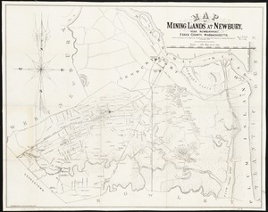
Map of mining lands at Newbury, near Newburyport, Essex County, Massachusetts
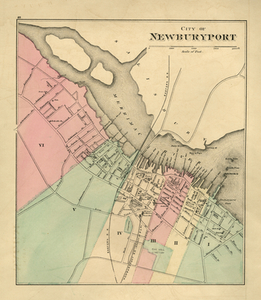
3.
Plan of Newburyport Mass. from an actual survey
4.
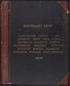
Atlas of the boundaries of the cities of Gloucester and Newburyport and towns of Amesbury, Essex, Georgetown, Groveland,...
5.
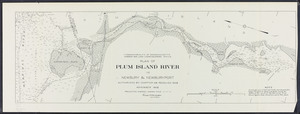
Plan of Plum Island River in Newbury and Newburyport
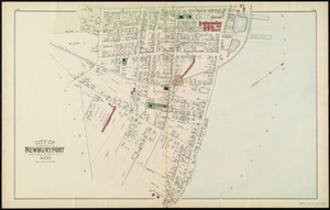
6.
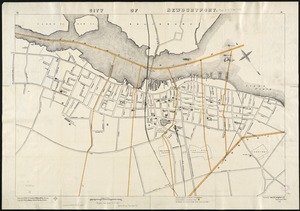
City of Newburyport
7.
Atlas of Massachusetts
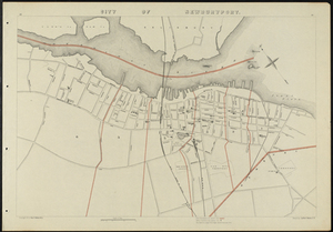
8.
City of Newburyport
9.
City of Newburyport
10.
City of Newburyport
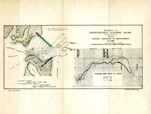
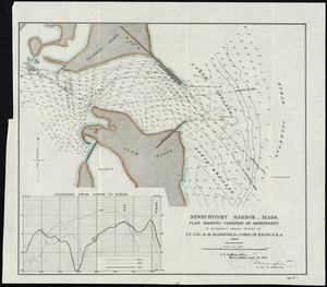
11.
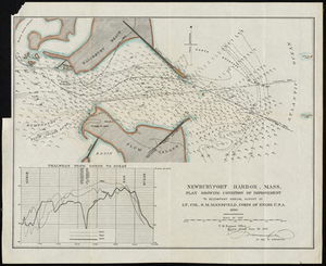
Entrance of Newburyport Harbor, Mass.: Plan Showing Condition of Improvement
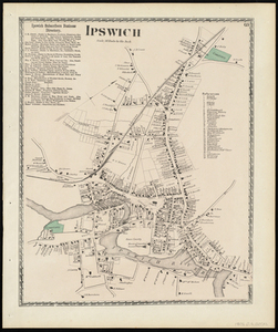
12.
Ipswich
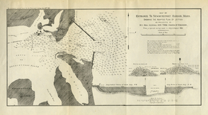
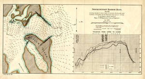
13.
Map of Entrance to Newburyport Harbor, Mass. Showing the Adopted Plan of Jetties
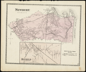
14.
Newbury
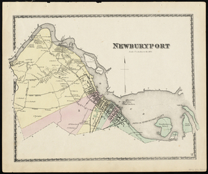
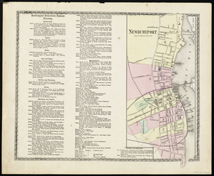
15.
Newburyport
16.
Newburyport
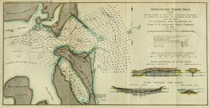
17.
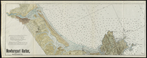
Newburyport Harbor, Mass.
18.
Newburyport Harbor, Mass. Plan Showing Changes in Shore Lines at Entrance, the Location and Condition of the Jetties, and the...
19.
Newburyport Harbor, Mass.: Plan Showing Changes in Shore Lines at Entrance, the Location and Condition of the Jetties, and the...
20.
Newburyport Harbor, Mass. Plan Showing Condition of Improvement
21.
Newburyport Harbor, Massachusetts
22.
The 100th anniversary map of Abraham Lincoln's visit to Massachusetts, September 11-23, 1848
23.
1630 shoreline
24.
1879. Progress map of the U.S. Geographical Surveys west of the 100th Meridian : prepared under the direction of 1st Lieut....
25.
1903 Map of Salem and surrounding places
26.
19th annual convention of the National Association of Real Estate Boards : at Tulsa, June 7 to June 11 in 1926
27.
2005 significant U.S. hurricane strikes
28.
227 Harzgerode
29.
305 Glatz
30.
38,000,000 escaped -- 10,000,000 died
31.
4 Kinten
32.
660 Wakulah St., Roxbury
33.
[A chart of Boston Bay and vicinity]
34.
[A chart of New York Island & North River : East River, passage through Hell Gate, Flushing Bay, Hampstead Bay, Oyster,...
35.
The A.A.A. key road map of continental Europe
36.
Aaron Bohrod's America, its history
37.
ABC pathfinder railway guide map : eastern division
38.
Aboriginal map of North America, denoting the boundaries and the locations of various Indian tribes
39.
Acapulco, México
40.
Accurata delineatio Castrorum Suecicorum, ut et Haffniae, Regni Daniae Metropolis
41.
Accurata delineatio oppugnatae a faederatis, Caesareis, Polonicis, Danicis, et Brandeburgicis copijs sub-ductu Seren: Electoris...
42.
Accurata delineatio regionis circa Nieburgum Fioniæ cum prælio ibi commisso inter Danorum et fæderatorum exercitum ab una et...
43.
Accurata Scaniae, Blekingiae et Hallandiae descriptio
44.
An accurate map of Cuba, and the adjacent islands
45.
An accurate map of Dorset Shire divided into hundreds
46.
An accurate map of Dorset Shire, divided into its hundreds
47.
An accurate map of England and Wales with the principal roads from the best authorities
48.
An accurate map of England and Wales with the principal roads from the best authorities
49.
An accurate map of Europe from the best authorities
50.
An accurate map of Hindostan or India, from the best authorities
« Previous
Next »
1
2
3
4
5
…
220
221
Limit your search
Subject
Real property--Massachusetts--Boston--Maps
2,278
Landowners--Massachusetts--Boston--Maps
2,117
Boston (Mass.)--Maps
1,967
Roxbury (Boston, Mass.)--Maps
351
Dorchester (Boston, Mass.)--Maps
317
Cambridge (Mass.)--Maps
266
Brookline (Mass.)--Maps
236
Real property--Massachusetts--Cambridge--Maps
216
more
Subject
»
Place
North and Central America
7,830
United States
6,448
Suffolk (county)
3,337
Boston
3,197
Massachusetts
3,183
Europe
963
Middlesex (county)
617
Canada
427
more
Place
»
Format
Maps/Atlases
10,957
Manuscripts
215
Prints
51
Books
35
Objects/Artifacts
10
Drawings/Illustrations
8
Posters
4
Available to use
No known restrictions
10,931
Creative Commons license
46
Date
View distribution
Current results range from
1482
to
2023
Date range begin
Date range end
View larger »
Collection
Norman B. Leventhal Map Center Collection
10,999
Boston and New England Maps (Collection of Distinction)
5,104
Urban Maps (Collection of Distinction)
4,845
Maritime Charts and Atlases (Collection of Distinction)
750
American Revolutionary War-Era Maps (Collection of Distinction)
615
Boston Redevelopment Authority Collection
86
Historic Maps
14
Massachusetts Board of Harbor and Land Commissioners
2
more
Collection
»
Institution
Boston Public Library
10,999
Salem State University Archives and Special Collections
14
State Library of Massachusetts
3


![[A chart of Boston Bay and vicinity]](https://bpldcassets.blob.core.windows.net/derivatives/images/commonwealth:cj82m2976/image_thumbnail_300.jpg)


