Search
Limit your search
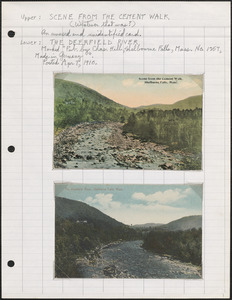
- Rivers5,224
- Roads3,420
- Hotels3,318
- Bridges3,223
- Monuments & memorials2,923
- Motels2,698
- Stores & shops2,036
- Mountains1,804
- North and Central America21,430
- United States21,025
- Massachusetts12,359
- Suffolk (county)3,120
- Boston2,908
- Essex (county)2,779
- Middlesex (county)1,633
- Europe1,440
- Photographs12,632
- Postcards/Cards8,633
- Maps/Atlases1,744
- Prints1,637
- Manuscripts168
- Ephemera104
- Drawings/Illustrations100
- Letters/Correspondence88
- Tichnor Brothers Postcard Collection7,512
- Land study maps, 1936-19371,680
- Bill Lane Photograph Collection1,543
- Leslie Jones Collection1,463
- Stereograph Collection951
- Arthur Griffin Photographs780
- Project DOCUMERICA Photographs by Ernst Halberstadt653
- Historical Society of Old Yarmouth Archives and Local History Collection553