Search
Limit your search
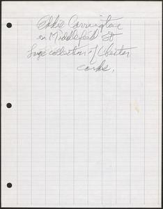
- North and Central America35,909
- United States35,431
- Massachusetts27,774
- Suffolk (county)8,016
- Boston7,428
- Essex (county)5,351
- Middlesex (county)3,644
- Barnstable (county)2,595
- Photographs26,684
- Postcards/Cards9,457
- Prints2,454
- Maps/Atlases1,775
- Drawings/Illustrations864
- Periodicals535
- Documents474
- Manuscripts269
- Tichnor Brothers Postcard Collection6,428
- Bill Lane Photograph Collection2,590
- Leslie Jones Collection2,488
- Land study maps, 1936-19371,680
- Press Photography from the Brearley Collection1,523
- Boston Pictorial Archive (Collection of Distinction)1,322
- Stereograph Collection1,316
- Arthur Griffin Photographs1,227