Search


Limit your search
- Roads3,420
- Motels2,665
- Beaches2,153
- Hotels2,063
- Cities & towns2,022
- Cities and towns1,680
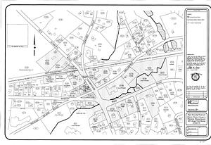
- Land use mapping1,680
- Soil mapping1,680
- North and Central America29,088
- United States28,433
- Massachusetts5,313
- Florida3,055
- New Jersey2,468
- New York1,763
- Pennsylvania1,541
- Virginia1,303
- Postcards/Cards27,956
- Photographs1,695
- Maps/Atlases1,694
- Prints146
- Ephemera52
- Film/Video37
- Manuscripts34
- Albums/Scrapbooks20
- Tichnor Brothers Postcard Collection27,817
- Land study maps, 1936-19371,680
- Bill Lane Photograph Collection309
- Boston Wharf Company Collection152
- Spencer Grant Collection110
- Leon Abdalian Collection70
- Project DOCUMERICA Photographs by Ernst Halberstadt67
- Samuel Chamberlain Photograph Negatives Collection, 1928-1971, undated53