Skip to search
Skip to main content
Skip to first result
Digital Commonwealth
Folders
Sign Up / Log In
Search for
Search
Search
Search
Basic
Advanced
Explore
Map
Collections
Institutions
Formats
For Educators
Primary Source Sets
Lesson Plans
Using Primary Sources
Searching Digital Commonwealth
For Institutions
Join Digital Commonwealth
Conferences, Trainings, & Events
How to Contribute Collections
Digitization Services
Board & Committees
Frequently Asked Questions
About
About Digital Commonwealth
News & Announcements
Copyright & Terms of Use
Harmful Content Statement
Partners
API
Contact Us
Search
Search Constraints
Start Over
Save Search
Your search:
More Like
commonwealth:7h149v85z
✖
Remove constraint More Like: commonwealth:7h149v85z
« Prev.
|
10,701
-
10,720
of
11,006
|
Next »
Sort
by date (desc)
relevance
title
date (asc)
date (desc)
Number of results to display per page
20
per page
per page
10
per page
20
per page
50
per page
100
per page
View results as:
List
list view
Maps
map view
Gallery
grid view
Search Results
10701.
Surria : vernacule Surrey
10702.
Suthsexia : vernacule Sussex
10703.
Wigorniensis comitatus cum Warwicensi, nec non Conventriae Libertas
10704.
Wiltonia sive comitatus Wiltoniensis : Anglis Wil Shire
10705.
Comitatus Dorcestria, sive Dorsettia : vulgo anglice Dorset Shire
10706.
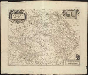
Dioecese de Rheims, et le païs de Rethel
10707.
Hassia Landgraviatus
10708.
Languedoc
10709.
Lincolnia comitatus : Anglis Lincoln-Shire
10710.
Totius Iutiae generalis accurata delincatio
10711.
Americae pars meridionalis
10712.
Guiana sive Amazonum regio
10713.
Lotharingia ducatus noua descriptio
10714.
Hollandia comitatus
10715.
L'Isle de France et lieux circövoysins
10716.
Carte du diocese d'Alby
10717.
Hollandiae pars septentrionalis, vulgo Westuriesland et 't Noorder Quartier
10718.
Rhenolandiae et Amstellandiae exactissima tabula
10719.
America Septentrionalis
10720.
Marchionatus Brandenburgicus
« Previous
Next »
1
2
…
532
533
534
535
536
537
538
539
540
…
550
551
Limit your search
Subject
Real property--Massachusetts--Boston--Maps
2,278
Landowners--Massachusetts--Boston--Maps
2,117
Boston (Mass.)--Maps
1,966
Roxbury (Boston, Mass.)--Maps
351
Dorchester (Boston, Mass.)--Maps
317
Cambridge (Mass.)--Maps
266
Brookline (Mass.)--Maps
236
Real property--Massachusetts--Cambridge--Maps
216
more
Subject
»
Place
North and Central America
7,815
United States
6,434
Suffolk (county)
3,338
Boston
3,198
Massachusetts
3,167
Europe
963
Middlesex (county)
617
Canada
427
more
Place
»
Format
Maps/Atlases
10,946
Manuscripts
215
Prints
51
Books
35
Objects/Artifacts
10
Drawings/Illustrations
8
Posters
4
Photographs
1
Available to use
No known restrictions
10,933
Creative Commons license
46
Date
View distribution
Current results range from
1482
to
2023
Date range begin
Date range end
View larger »
Collection
Norman B. Leventhal Map Center Collection
11,003
Boston and New England Maps (Collection of Distinction)
5,106
Urban Maps (Collection of Distinction)
4,846
Maritime Charts and Atlases (Collection of Distinction)
750
American Revolutionary War-Era Maps (Collection of Distinction)
615
Boston Redevelopment Authority Collection
86
Sidney R. Knafel Map Collection at Phillips Academy
2
Chinese Progressive Association Records
1
Institution
Boston Public Library
11,003
Phillips Academy
2
Northeastern University Library
1