Skip to search
Skip to main content
Skip to first result
Digital Commonwealth
Folders
Sign Up / Log In
Search for
Search
Search
Search
Basic
Advanced
Explore
Map
Collections
Institutions
Formats
For Educators
Primary Source Sets
Lesson Plans
Using Primary Sources
Searching Digital Commonwealth
For Institutions
Join Digital Commonwealth
Conferences, Trainings, & Events
How to Contribute Collections
Digitization Services
Board & Committees
Frequently Asked Questions
About
About Digital Commonwealth
News & Announcements
Copyright & Terms of Use
Harmful Content Statement
Partners
API
Contact Us
Search
Search Constraints
Start Over
Save Search
Your search:
More Like
commonwealth:4m90f405r
✖
Remove constraint More Like: commonwealth:4m90f405r
« Prev.
|
9,701
-
9,800
of
11,000
|
Next »
Sort
by relevance
relevance
title
date (asc)
date (desc)
Number of results to display per page
100
per page
per page
10
per page
20
per page
50
per page
100
per page
View results as:
List
list view
Maps
map view
Gallery
grid view
Search Results
9701.
Section 16: Chemnitz
9702.
Section 16: Chemnitz
9703.
Section of a track chart of the world, covering the Behring Sea
9704.
Sectional & topographical map of Holmes County, Ohio
9705.
A sectional map of Massachusetts, engraved expressly for Chapin's farm advertiser, 1871 : including the proposed Massachusetts...
9706.
Sectional map of the northern portion of Vancouver Island
9707.
Sectional map of the Old Colony Railroad South Shore, Nantasket Beach and Plymouth lines
9708.
Sections of soundings made by order of the Harbor Committee of 1852
9709.
Secunda Affrice tabula continet Affricam & insulae que circa ipsam sunt
9710.
Secunda Africae tabula
9711.
Secunda Asiae tabula
9712.
Secunda Asie tabula continet Sarmatia ipsius
9713.
Secunda Europae tabula
9714.
Secunda Europe tabula
9715.
Segusiani : partie du dioecese et archevesche de Lyon : Le Bas Forez et Beaujolois : eslectons de Roanne et de Villefranche
9716.
Segusiani : partie du dioese et archevche de Lyon : le Lyonnois et le haut forez : eslections de Lyon, de St. Chamont, et de...
9717.
Selected hurricanes affecting the southern United States 1954-1977
9718.
Senones : Evesché d'Auxerre : Comté et Ballge d'Auxerre : Eslectons. de Clamecy, de Gien, de la Charité, et de Vezelay
9719.
Septentrionalium terrarum descriptio
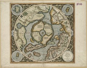
9720.
Septima Asia tabula continet Margianam, Bactrianam, Sogdianos, Sacas & Scythiam intra Imaū mōtē
9721.
Septima Asiae tabula
9722.
Septima Europa tabula continet Sardininiam & Sicilia insulas
9723.
Septima Europae tabula
9724.
Ser. Reg. Caroli Gustavi victoriolus e Sialandia disccssus facta pace Rothschildenli d. 5 Martij 1658 ; Ser. Reg. Sueciæ...
9725.
Serbien : nach Österreichischen und Russischen aufnahmen und ortsbestimmungen, und den karten von Viquesnel und Bugarski
9726.
Serio-comic war map for the year 1877
9727.
Al sermo. Ferdinando. II. Grandvca di Toscana svo signore Don Roberto Dudleo, Duca di Northumbria
9728.
Seven miles around Jerusalem : from original surveys and observations
9729.
The Seven United Provinces of Holland, Groningen, Gelders, Friesland, Overyssel, Utrecht and Zealand : from the best authorities
9730.
The Seven United Provinces of Netherland : with its circumjacent borders
9731.
The seven United Provinces, with their roads and divisions
9732.
The Seventh Ward of Philadelphia : the distribution of Negro inhabitants throughout the ward, and their social conditions
9733.
Sexta Asiae tabula
9734.
Sexta Asie tabula continet Arabiam, Felice atq[ue] Carmania cu adiacentibus insulis
9735.
Sexta Europa tabula continet Italiam
9736.
Sexta Europae tabula
9737.
Shadow analysis
9738.
Shah Bay, Loo Choo I.
9739.
Shaker Village
9740.
Shall Union Square overshadow the United States? : America's other 60 families : the real rulers of America
9741.
Shamokin : Pennsylvania, 1884
9742.
A shared problem, an unequal burden : causes & consequences of climate change
9743.
Sheboygan County, Wis.
9744.
Shepherd's map of the seat of war
9745.
Sherman & Smith's rail road, steam boat & stage route map of New England, New-York, and Canada
9746.
Shewey's new map of the city of St. Louis
9747.
Shíjú tú
9748.
Shipyard Park phase 3 : Boston Naval Shipyard at Charlestown : schematic design
9749.
Shoshone National Forest, Wyoming
9750.
Showing rental values in greater Tokyo - 1926
9751.
Siberia
9752.
Das Siebengebirge
9753.
The siege of Colberg, from 3d. to 31st. October, 1758
9754.
Siege of Strasbourg, 1870
9755.
Siege of Strasbourg, 1870 : enlarged sketch of works
9756.
Siege of Vera Cruz, by the U.S. troops under Major General Scott, in March 1847, from surveys made by Major Turnbull, Captains...
9757.
Siege operations at Spanish Fort, Mobile Bay : by the U.S. forces under Maj. Gen. Canby. Captured by the Army of West Miss. on...
9758.
Siskiyou National Forest, Oregon and California
9759.
Site preparation contract for the reconstruction of Copley Square Park, City of Boston, Massachusetts : contract documents
9760.
Site preparation contract tree planting - various locations
9761.
Sitgreaves National Forest, Arizona
9762.
Situation des armées Françaises depuis le 10 mars jusqu'à la bataille de Wurtchen : (Campagne de 1813)
9763.
Situations plan der Englischen Armée vor und um Boston nebst der stellung der Americaner
9764.
Situs loci in quo Sereniss. Princ. Sueciae General. mus. subito hoste q. inscio lintribus Vistulam inter Montower Spitz et...
9765.
Situs locorum circa Neoburgum in Fionia, et positus exercituum vtriusq: partis, ante conflictum, d. 14. Nouemb. 1659
9766.
Siuslaw National Forest, Oregon
9767.
Skeleton map of rail-roads between Cape Canso and St. Louis
9768.
Skeleton map of the territory of the United States west of the Mississippi River : exhibiting the relations existing between...
9769.
Skeleton map showing the rail roads completed and in progress in the United States and their connection as proposed with the...
9770.
Skeleton plan, showing location of the Suffolk & Metropolitan rail road routes in Boston
9771.
Sketch A no. 5 showing proposed site for a light house on Sow and Pigs Reef
9772.
Sketch map from the Dardanelles to the Bosphorus showing the positions of the British fleet
9773.
Sketch map of Boston and the Public Library system
9774.
Sketch map of Boston and the Public Library system
9775.
Sketch map of Boston and the Public Library system
9776.
Sketch map of New South Wales showing the localities of the principal minerals 1876
9777.
Sketch map of part of Cassiar District : shewing Atlin Gold Fields B.C. ; to accompany report of Minister of Mines Victoria 1898
9778.
Sketch map of the British coast showing the relative positions of Liverpool, Beaumaris, Moelfra Bay & Point Lynas (taken from...
9779.
Sketch of Boston Harbor and Bay
9780.
Sketch of Bunker Hill Battle
9781.
Sketch of Charleston Harbor
9782.
Sketch of Charleston Harbor
9783.
Sketch of Charleston Harbor
9784.
Sketch of Guadalupe Island : west coast of Lower California
9785.
A sketch of part of the Island of New York shewing the operations of His Majesty's troops on the 16 Novr. 1776 which terminated...
9786.
Sketch of Pensacola Navy Yard and Fort Pickens from U.S. coast surveys
9787.
Sketch of sea coast of South Carolina and Georgia from Bull's Bay to Ossabaw Sound
9788.
Sketch of sea coast of South Carolina and Georgia from Bull's Bay to Ossabaw Sound
9789.
Sketch of the 11th district of western Tennessee
9790.
Sketch of the Battle of Bunker Hill
9791.
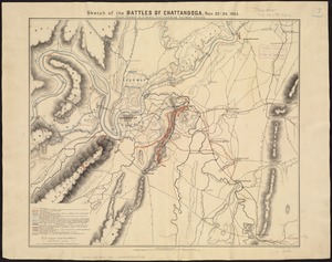
Sketch of the battles of Chattanooga, Nov. 23-26, 1863
9792.
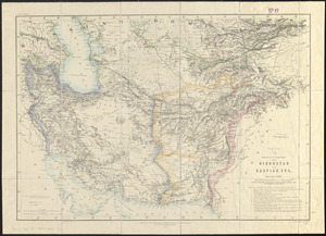
Sketch of the countries between Hindustan and the Caspian Sea
9793.
Sketch of the country illustrating the late engagement in Long Island
9794.
A sketch of the environs of Charlestown in South Carolina
9795.
Sketch of the narrows in Boston Harbor
9796.
Sketch of the navigation through East Neebish Rapids River St. Marys
9797.
Sketch of the navigation through East Neebish Rapids, River St. Marys
9798.
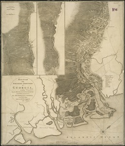
Sketch of the northern frontiers of Georgia, extending from the mouth of the River Savannah to the town of Augusta
9799.
A sketch of the operations before Charlestown the capital of South Carolina
9800.
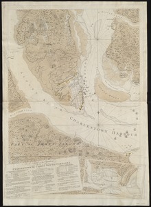
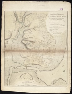
Sketch of the position of the British forces at Elizabeth Town Point after their return from Connecticut Farm, in the province...
« Previous
Next »
1
2
…
94
95
96
97
98
99
100
101
102
…
109
110
Limit your search
Subject
Real property--Massachusetts--Boston--Maps
2,278
Landowners--Massachusetts--Boston--Maps
2,117
Boston (Mass.)--Maps
1,966
Roxbury (Boston, Mass.)--Maps
351
Dorchester (Boston, Mass.)--Maps
317
Cambridge (Mass.)--Maps
266
Brookline (Mass.)--Maps
236
Real property--Massachusetts--Cambridge--Maps
216
more
Subject
»
Place
North and Central America
7,814
United States
6,433
Suffolk (county)
3,337
Boston
3,197
Massachusetts
3,166
Europe
964
Middlesex (county)
617
Canada
427
more
Place
»
Format
Maps/Atlases
10,941
Manuscripts
215
Prints
51
Books
35
Objects/Artifacts
10
Drawings/Illustrations
8
Posters
4
Available to use
No known restrictions
10,931
Creative Commons license
46
Date
View distribution
Current results range from
1482
to
2023
Date range begin
Date range end
View larger »
Collection
Norman B. Leventhal Map Center Collection
10,999
Boston and New England Maps (Collection of Distinction)
5,105
Urban Maps (Collection of Distinction)
4,846
Maritime Charts and Atlases (Collection of Distinction)
750
American Revolutionary War-Era Maps (Collection of Distinction)
615
Boston Redevelopment Authority Collection
86
Historic Maps
1
Institution
Boston Public Library
10,999
Salem State University Archives and Special Collections
1


![Sexta Asie tabula continet Arabiam, Felice atq[ue] Carmania cu adiacentibus insulis](https://bpldcassets.blob.core.windows.net/derivatives/images/commonwealth:7h14b122w/image_thumbnail_300.jpg)