Skip to search
Skip to main content
Skip to first result
Digital Commonwealth
Folders
Sign Up / Log In
Search for
Search
Search
Search
Basic
Advanced
Explore
Map
Collections
Institutions
Formats
For Educators
Primary Source Sets
Lesson Plans
Using Primary Sources
Searching Digital Commonwealth
For Institutions
Join Digital Commonwealth
Conferences, Trainings, & Events
How to Contribute Collections
Digitization Services
Board & Committees
Frequently Asked Questions
About
About Digital Commonwealth
News & Announcements
Copyright & Terms of Use
Harmful Content Statement
Partners
API
Contact Us
Search
Search Constraints
Start Over
Save Search
Your search:
More Like
commonwealth:2227np080
✖
Remove constraint More Like: commonwealth:2227np080
« Prev.
|
421
-
440
of
726
|
Next »
Sort
by relevance
relevance
title
date (asc)
date (desc)
Number of results to display per page
20
per page
per page
10
per page
20
per page
50
per page
100
per page
View results as:
List
list view
Maps
map view
Gallery
grid view
Search Results
421.
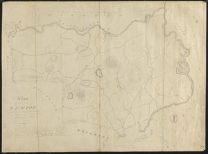
Plan of Newton made by E. F. Woodward and W. F. Ward, dated 1831
422.
Plan of Newton surveyed by Jonathan Kingsbury, dated 1794.
423.
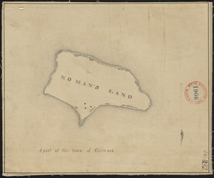
Plan of No Man's Land (Chilmark), surveyor's name not given, dated 1830
424.
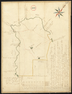
Plan of No Town (Princeton), surveyor's name not given, dated 1838
425.
Plan of Nobleborough, made by Ephraim Robings, dated March 24, 1795.
426.
Plan of Norridgewock, made by Daniel Steward, dated March 2, 1795.
427.
Plan of North Brookfield made by Bonum Nye, dated 1830
428.
Plan of North Yarmouth surveyed by Asa Lewis, dated 1794-5.
429.
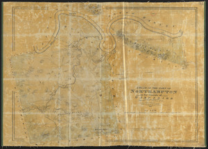
Plan of Northampton made by John G. Hales, dated 1831
430.
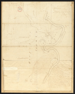
Plan of Northampton surveyed by J Denison, dated November, 1794.
431.
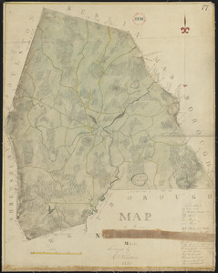
Plan of Northborough made by Gill Valentine, dated 1830
432.
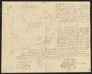
Plan of Northborough surveyed by Silas Keyes, dated February 23, 1795.
433.
Plan of Northbridge made by Frederic Taft, dated November 1830
434.
Plan of Northbridge surveyed by Jonathan Adams and Amariah Preston, dated Mar. 2, 1795.
435.
Plan of Northfield made by Arthur W. Hoyt, dated 1830
436.
Plan of Northfield surveyed by Xenophon Janes,dated May 1795.
437.
Plan of Norton made by C. Leonard and E. Lincoln, dated October 1830
438.
Plan of Norton made by E. Lincoln and C. Leonard, dated October 1830
439.
Plan of Norton surveyed by Silas Cobb, dated November, 1794.
440.
Plan of Norway (Rustfield), surveyor's name not given, dated December 1795.
« Previous
Next »
1
2
…
18
19
20
21
22
23
24
25
26
…
36
37
Limit your search
Place
North and Central America
724
United States
723
Massachusetts
295
Maine
128
Worcester (county)
109
Middlesex (county)
76
Franklin (county)
61
Berkshire (county)
59
more
Place
»
Format
Maps/Atlases
726
Available to use
No known restrictions
726
Date
View distribution
Current results range from
1786
to
1898
Date range begin
Date range end
View larger »
Collection
Town plans, 1794
402
Town plans, 1830
324
Institution
Massachusetts Archives
726