Skip to search
Skip to main content
Digital Commonwealth
Sign Up / Log In
Search for
Search
Search
Search
Basic
Advanced
Explore
Map
Collections
Institutions
Formats
For Educators
Primary Source Sets
Lesson Plans
Using Primary Sources
Searching Digital Commonwealth
For Institutions
Join Digital Commonwealth
Conferences, Trainings, & Events
How to Contribute Collections
Digitization Services
Board & Committees
Frequently Asked Questions
About
About Digital Commonwealth
News & Announcements
Copyright & Terms of Use
Harmful Content Statement
Partners
API
Contact Us
Boston Public Library
Norman B. Leventhal Map Center Collection
/
Urban Maps (Collection of Distinction)
/
Boston and New England Maps (Collection of Distinction)
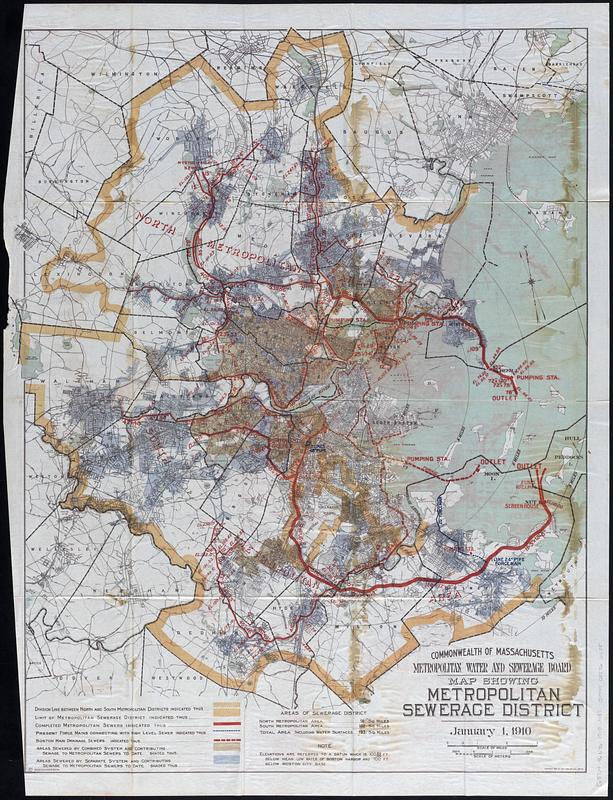
Map showing metropolitan sewerage district : January 1, 1910
Map showing metropolitan sewerage district
×
Item Information
Title:
Map showing metropolitan sewerage district : January 1, 1910
Cartographer:
Massachusetts. Metropolitan Sewerage Commission
Copyright claimant:
Geo. H. Walker & Co.
Printer:
Wright & Potter
Copyright holder:
Walker Lith. & Pub. Co.
Name on Item:
Commonwealth of Massachusetts Metropolitan Water and Sewerage Board
Date:
[1910]
Format:
Maps/Atlases
Location:
Boston Public Library
Norman B. Leventhal Map Center
Collection (local):
Norman B. Leventhal Map Center Collection
Subjects:
Boston Metropolitan Area (Mass.)--Maps
Sewerage--Massachusetts--Boston Metropolitan Area--Maps
Sanitary districts--Massachusetts--Boston Metropolitan Area--Maps
Places:
Suffolk (county)
>
Boston
Extent:
1 map : color ; 77 x 59 cm
Permalink:
https://ark.digitalcommonwealth.org/ark:/50959/zg64x867s
Terms of Use:
No known copyright restrictions.
No known restrictions on use.
Publisher:
[Boston] : [Wright & Potter Printing Co.]
Scale:
Scale approximately 1:53,000
Language:
English
Notes:
Relief shown by spot heights.
Detached from Ninth annual report of the Metropolitan Water and Sewerage Board for the year 1909 (Boston : Wright & Potter Printing Co., 1910).
Notes (date):
This date is inferred.
Identifier:
06_01_018356
Call #:
G3764.B6N46 1910 .M37
Barcode:
39999085966685
show more...
View MODS XML
More Like This
Bay State Street Ry. Co's lines and connections
Boston personal income ; Boston personal income [and] residential ...
How we get around today
Map of Commonwealth Avenue Street Railway Company, and connecting ...
Find More Like This >>
Tools
Share
Facebook
Pinterest
X
Reddit
Tumblr
Email
Copy link
Add to Folder
Questions/Comments
Cite This Item
IIIF Manifest
Downloads
Primary (full resolution, uncompressed)
(TIF, 111 MB)
Large (full resolution)
(JPEG, 9.32 MB)
Medium
(JPEG, 155 KB)

![Boston personal income ; Boston personal income [and] residential population density](https://bpldcassets.blob.core.windows.net/derivatives/images/commonwealth:fn107c409/image_thumbnail_300.jpg)

