Skip to search
Skip to main content
Digital Commonwealth
Sign Up / Log In
Search for
Search
Search
Search
Basic
Advanced
Explore
Map
Collections
Institutions
Formats
For Educators
Primary Source Sets
Lesson Plans
Using Primary Sources
Searching Digital Commonwealth
For Institutions
Join Digital Commonwealth
Conferences, Trainings, & Events
How to Contribute Collections
Digitization Services
Board & Committees
Frequently Asked Questions
About
About Digital Commonwealth
News & Announcements
Copyright & Terms of Use
Harmful Content Statement
Partners
API
Contact Us
Boston Public Library
Norman B. Leventhal Map Center Collection
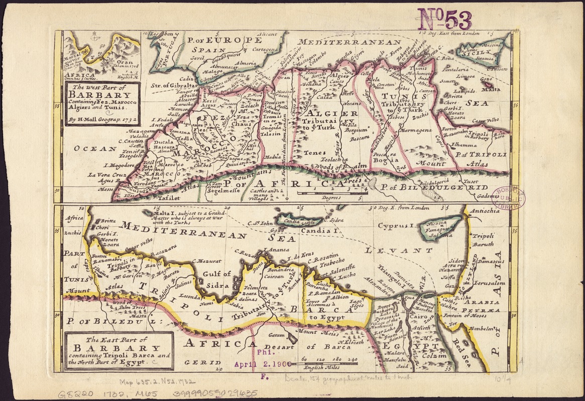
The west part of Barbary containing Fez, Marocco, Algiers and Tunis / : The east part of Barbary containing Tripoli, Barca and the north part of Egypt
The west part of Barbary containing Fez, Marocco, Algiers and Tunis /
×
Item Information
Title:
The west part of Barbary containing Fez, Marocco, Algiers and Tunis / : The east part of Barbary containing Tripoli, Barca and the north part of Egypt
Title (alt.):
East part of Barbary containing Tripoli, Barca and the north part of Egypt
Creator:
Moll, Herman, d. 1732
Name on Item:
by H. Moll, Geograp[her], 1732
Date:
[1736]
Format:
Maps/Atlases
Location:
Boston Public Library
Norman B. Leventhal Map Center
Collection (local):
Norman B. Leventhal Map Center Collection
Subjects:
Africa, North--Maps--Early works to 1800
1732
Places:
North Africa
(area)
Extent:
2 maps on 1 sheet : col. ; each 10 x 27 cm, on sheet 23 x 34 cm.
Permalink:
https://ark.digitalcommonwealth.org/ark:/50959/z890s2854
Terms of Use:
No known copyright restrictions.
No known restrictions on use.
Publisher:
London : Printed by T. Bowles & J. Bowles
Scale:
Scale [ca. 1:11,000,000]
Language:
English
Notes:
Relief shown pictorially.
Includes inset map of the Oran region.
Appears in the author's Atlas Minor. London : Thomas Bowles and John Bowles, [1736].
Notes (date):
This date is inferred.
Identifier:
06_01_007103
Call #:
G8220 1732 .M65
Barcode:
39999059029635
show more...
View MODS XML
More Like This
Barbaria
In notitiam ecclesiasticam Africæ tabula geographica
Pascaart van Europa, als mede een gedeelt vande cust van Africa
Prima Africae tabula
Find More Like This >>
Tools
Share
Facebook
Pinterest
X
Reddit
Tumblr
Email
Copy link
Add to Folder
Questions/Comments
Cite This Item
IIIF Manifest
Downloads
Primary (full resolution, uncompressed)
(TIF, 129 MB)
Large (full resolution)
(JPEG, 10.8 MB)
Medium
(JPEG, 419 KB)